
How High Resolution Digital Aerial Cameras Help NASA in Forest Regrowth Study
Using High-Resolution, Multi-sensor Data to Characterize Puerto Rican Forests. After hurricane deforestation in Puerto Rico, NASA scientists study forest regrowth using high-resolution, multi-sensor data. As a key component of NASA’s G-LiHT system, a 100-megapixel Phase One Industrial camera was used to produce RGB photographs for the identification of fine-scale canopy features.
Identify Individual Flowers from the Air at 200 mph using Multiple Sensors
In 2017, NASA launched a project funded by the U.S. Department of Energy to study tropical forest regrowth rates. Ecologists were also interested in the role of tropical forests in terms of sequestering carbon. The project consisted of forest data acquisition through airborne Lidar and image data, as well as ground measurements and terrestrial Lidar scanning.
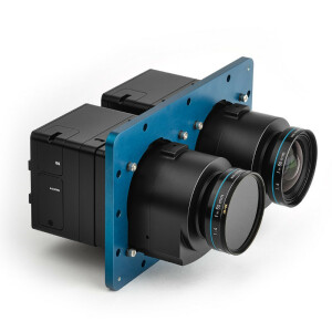
NASA’s G-LiHT is a portable, airborne imaging system that simultaneously maps the composition, structure, and function of terrestrial ecosystems using Dual Scanning RIEGL Lidars, VNIR Imaging Spectroscopy, Broad Band Thermal Imaging, High-Resolution Aerial Photos using Phase One Industrial 100MP, and an Applanix POS AV V6 precision GPS Inertial Navigation System.

G-LiHT simultaneously maps the composition, structure, and function of terrestrial ecosystems using: Lidar; VNIR Imaging spectroscopy; Thermal measurements; stereo RGB photographs; and Solar-Induced Fluorescence (SIF).
"Phase One’s 100MP camera provided the opportunity to develop new algorithmic approaches that can handle large volumes of high-resolution imagery" - Dr. Bruce Cook Project Scientist - NASA's Goddard Space Flight Center
The African Tulip Tree

Spathodea campanulata, or African Tulip Tree, is a non-native tree species with orange-coloured flowers that occupies much of the island. It is a very effective colonizer following the disturbance and abandonment of agricultural land. The researchers were interested in producing maps of the island that showed where the tree was found, and how much forest canopy volume it represented. A combination of airborne Lidar and optical image data was used, to characterize the tree canopy. Data collected enables data-fusion studies by providing coincident data in time and space and provides fine-scale (<1m) observations over the large areas that are needed in many ecosystem studies. NASA developed a classification algorithm that can automatically locate the orange flowers in fine-resolution aerial imagery.
NASA’S G-LIHT (V2.0)

NASA’S Goddard’s Lidar, Hyperspectral and Thermal Airborne Imager (G-LIHT) use Lidar to provide 3D information about the spatial distribution of canopy elements, visible and near-infrared (VNIR) imaging spectroscopy to discern species composition, and variations in biophysical variables and thermal measurements to delineate wetlands and to detect heat and moisture stress in vegetation.
Dr Bruce Cook from NASA explains “We can better characterize forest ecosystems with multiple sensors as opposed to one killer sensor that does everything. For example, we merged fine-resolution imagery from the Phase One camera with Lidar data to quantify forest canopy volume that is occupied by Spathodea.”
Integrated System

The system includes:
- Phase One 100 MP aerial photographs
- Two Riegl scanning LiDARs
- Hyperspec VNIR imaging spectrometer
- SIF imaging spectrometer
- Downwelling irradiance spectrometers
- Thermal infrared camera
- Precision GPS/IMU
Data Acquisition
Airborne data has a finer resolution than satellite imagery taken of the same area. Observations on the ground can be scaled to airborne and satellite data. Moderate- and coarse-resolution satellite data provides a wide-area coverage at a greater temporal frequency, but often with less spatial detail. Approximately 50 flight hours were carried out in 2017. The same areas were re-flown in 2018, following hurricanes Irma and Maria. A user-interactive map available on the G-LiHT website allows data to be viewed and downloaded.

G-LiHT uses Lidar to provide 3D information about the spatial distribution of canopy elements, VNIR (visible to near-infrared) imaging spectroscopy to discern species composition, and variations in biophysical variables and thermal measurements to delineate wetlands and to detect heat and moisture stress in vegetation.
Fine Resolution Imagery to Find Flowers
Phase One Industrial cameras produce high-resolution images with the required 3cm GSD. This made it possible to identify individual flowers within thousands of pixels.
“Identifying trees that may be in decline is important for forest health studies. This project has been an excellent testbed for making tools for detecting insect and disease outbreaks. Being able to characterize forest health conditions over large areas is important for ecosystem monitoring”.
"Phase One's high-resolution aerial imagery forms part of our new digital classification techniques, which open up a whole new territory for NASA," explains Cook.

Fine-resolution images (~3 cm GSD) where individual flowers can be found in thousands of pixels.
Do you have questions about this case study?
Get in touch with Phase One A/S, and they would be happy to answer any questions you have about pricing, suitability, availability, specs, etc.

Related products


![Do-Giant-Tortoises-Make-Good-Neighbors-1[1].jpg](https://cdn.geo-matching.com/vRMO2Edp.jpg?w=320&s=a6108b2726133ff723670b57bc54c812)


