![Do-Giant-Tortoises-Make-Good-Neighbors-1[1].jpg](https://cdn.geo-matching.com/vRMO2Edp.jpg)
Using Eos GNSS and Galileo HAS in the Galápagos to analyze the impact of new tortoise species on Santa Fe Island
Journey to the small island of Santa Fe, Galápagos. Santa Fe Island, also known as Barrington Island, is a small island of 24 square kilometers which lies in the middle of the Galápagos Archipelago in Ecuador.


Santa Fe Island is home to special tortoises and unique iguanas who share this treeless, rocky island with spiders, snakes, and giant centipedes. More recently, the island has served as a temporary homebase for ecologist Charles Lehnen, as he performs his dissertation research for the University of Southern California in collaboration with Galápagos Conservancy and Fundación Conservando Galápagos as part of the Initiativa Galápagos Program.
“I’ve been traveling to the Galápagos for eight years, but [my summer 2023 trip] was a big step forward because this was for a full three weeks on an uninhabited, fully protected island,” Lehnen said. “[It made a] really big difference to have this whole island to myself, to explore for a month.”
Lehnen’s work focuses on the interactions between and implications of the island’s iguana and tortoise species. Lehnen’s research centers around a single critical question, stemming from environmentalists’ “wild” idea to repopulate Santa Fe Island with tortoises: “What happens to these islands when keystone herbivores get put back?” asks Lehnen.
Rewilding an Island
Until recently, Santa Fe Island had not been home to tortoises for nearly 150 years. Once integral to the island’s ecosystem, the Santa Fe Island tortoise served as the island’s main herbivore, responsible for the very important tasks of seed dispersal, foraging, and nutrient cycling (the transfer of organic and inorganic matter between living and non-living environmental components, such as tortoise and soil). When the Santa Fe Island tortoise became extinct in the mid-1800s, the next most impactful herbivore — the endemic Santa Fe Land-Iguana— could not fully fill its absence. Thus, the island’s ecosystem was permanently disrupted.
Then in 2015, local conservationists put into action a “wild” idea to introduce as an ecological replacement, the Española Island tortoise. According to Lehnen, repopulating Santa Fe Island with the Española Island tortoises created an “ecological proxy,” a concept whereby an existing species can adopt the ecological role of a similar but extinct species.
“We’re hoping [the Española Island tortoises] are going to restore that ecosystem, and it’s going to have a cascading effect on every other species there,” Lehnen said.

Through Lehnen’s research, which will continue through 2026, he hopes to document what true ecological effects the introduction effort has had.
Studying Sante Fe Island
Lehnen’s research will revolve in large part around a concept of “biogeography.” This means studying the relationship of the Española Island tortoises, the Santa Fe Land-Iguana, their potentially changing distributions around the island, and their interactions and effects on each other and the island ecosystem. For millions of years, but especially since the extinction of the Santa Fe Island tortoise, the Sante Fe Land-Iguana has had a significant and determinative effect on the island’s plant communities. This stems from the iguana’s selective grazing and foraging, and the resultant seed dispersal. Throughout the island, Lehnen hypothesizes these iguanas have typically distributed seeds in small areas. Now that the Española Island tortoises have been introduced, Lehnen theorizes that the tortoises could be having a transformative effect on the island’s plant communities — as they would have had when the Santa Fe Island tortoises ruled.
“The tortoises are carrying these seeds across the whole island,” Lehnen said, “compared to the hundreds of years of isolated areas where iguanas distributed them.”

Lehnen is also exploring the impact of the tortoises on both species’ feeding behavior. Tracking this requires carefully planned, long-term data collection and analysis. During this first trip, Lehnen collected keratin samples from the shells and nails of the tortoises and from the nails and scales of the iguanas (while following strict Galapagos National Park safety and humane protocols). The team will send these samples to a university lab, where isotopes from the keratin can be analyzed to determine what the tortoises and iguanas have been eating. Over time, this data could provide insights — such as dietary overlap — into the current and diets of both species.

The team also placed camera traps, to see if they can capture evidence of the two species interacting with the same or different parts of plants. The camera traps should help reveal areas of high activity, so Lehnen can place a greater density of camera traps and focus his observations during future trips.
The Challenges Island Life Poses to High-Tech Research
Santa Fe Island is the definition of “off the grid.” Many days during Lehnen’s trip, the humidity rose above 90% and temperatures surpassed 90°F (32.2°C). Because every rock is volcanic, flat surfaces are rare. Trips to fly drones often took the entire day, starting before sunrise at 4:30 a.m. and lasting until sunset at about 6:30 p.m. This posed a challenge for battery life, hydration (the research team lived off 46 hand-carried five-gallon water containers), and even important cables that attracted the biting teeth of endemic and curious sharp-toothed rats. Field conditions were so challenging that one of Lehnen’s two assistants left early and had to be replaced.
“If you need it or want it, you bring it with you,” Lehnen said of their supplies, most of which he purchased with grant-money he’d acquired.
Suffice it to say, the team needed their gear to be as rugged and self-sustaining as possible.

Bug Juice for Drone Flights
Lehnen’s DJI Mavic 3 Multispectral drone required a lot of battery power. They discovered the best workflow was to charge their solar battery during the day and then hook up to a generator to the solar battery for four hours at night. That gave them enough juice to power everything during their long days.
Taking advantage of long sunny days on the equator, the team was able to hike to every destination needed to capture the whole island with the drone. Drone work consisted of hiking to the sites of launch locations and ground control points (GCPs). GCPs are survey points that can be easily identified in imagery to help drone pilots and drone software precisely geo-reference imagery. Because of this, coordinates of GCPs need to be extremely accurate.

“
“The precision with [the Arrow Gold+ and Galileo HAS] was incredible. I will use one for every project I ever do, ever.”
Charles Lehnen, Ecologist, University of Southern California
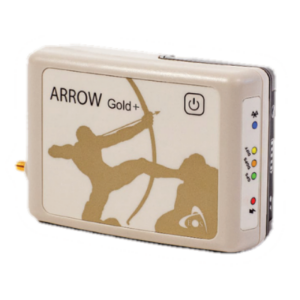
To set GCPs, the team placed highly visible laminated targets on the ground and used an Arrow Gold+™ global navigation satellite system (GNSS) receiver to survey the location. The Arrow Gold+ can connect to a new GNSS correction service known as Galileo High Accuracy Service (HAS). Currently in its initial service phase since January 2023, Galileo HAS is a free worldwide service that provides 10-20 cm (about six inches) of accuracy after converging. Lehnen’s results are the first recorded using Galileo HAS in the Galápagos.
To reduce battery consumption while still giving the Arrow Gold+ enough time to converge, Lehnen would power on the Arrow Gold+ about 30 minutes prior to arriving at each work site. On average, he achieved approximately five cm-level accuracy.
“The precision with [the Arrow Gold+ and Galileo HAS] was incredible,” Lehnen said. “I will use one for every project I ever do, ever.”


Where To, Next?
The summer 2023 trip was just the beginning of Lehnen’s project. In spring 2024, Charles will lead a USC program that will engage undergraduates to help analyze his drone imagery for vegetation information. They will use artificial intelligence (AI) and machine learning (ML) to identify the distribution of vegetation, such as cacti, from the drone imagery. This undergraduate research project will help Lehnen and his team complete the otherwise manual labor of creating training and validation datasets for the ML algorithm. To classify vegetation, Lehnen will use Esri’s ArcGIS® software and Python scripting; he can then use satellite imagery taken over the past 15 years to compare at plant distributions before and after the introduction of the tortoises. His findings — along with the lab’s isotope-sample results and camera-trap imagery activity analysis — will help Lehnen determine where to focus his research on future trips.
Three more trips are planned: one each in summer and fall of 2024, and a final trip in 2025.

A Satisfying Ending, Which is Also Just the Beginning
Lehnen’s work is important not only for how it stands to shape our collective understanding of the larger role species play before they go extinct, but also as a milestone for Lehnen’s future as a scientist — in an area of the world famous for generating provocative revelations about our natural world.
On the last day of this trip, Lehnen reflected on his accomplishments with guiding his team toward what are hopefully insightful findings. In the past, Lehnen had completed components of similar work individually, such as applying for grants, collecting field data, strategizing drone flights, and so on. But never had he combined these skills into a single project of such magnitude. During his last morning on Santa Fe Island, while his assistants packed camp and waited for a grant-funded charter boat to pick them up, Lehnen went for one last drone flight. The day prior, their battery had died, leaving this as their last needed flight of the trip.
“That last morning, when I was flying that drone, I was looking up and thinking, ‘I did this. This is amazing.’”

Charles Lehnen would like to thank his primary collaborator Dr. Washington Tapia; the Galápagos Conservancy/Conservando Galápagos for all technical and logistical support; his doctoral advisor Dr. Craig Stanford; and his field assistants Simon Rouot, Juan José Gallardo, and Mary Cate Hyde for their support in making this expedition a success.
Do you have questions about this case study?
Get in touch with Eos Positioning Systems, and they would be happy to answer any questions you have about pricing, suitability, availability, specs, etc.

Related products


