


3D Survey of a historical road pavement in Italy
Carrying out maintenance works in historic centres can present several challenges and difficulties, mainly due to the unique characteristics of these places. This is why careful and respectful planning towards heritage conservation is required whenever works that may alter the architecture are to be carried out.
The case of Bolsena
Due to extraordinary maintenance work on a portion of the sewage network in the municipality of Bolsena, Italy, it was necessary to carry out a detailed mapping of the historic road surface to ensure that the pavement was restored as it was originally.
Whenever an intervention of this type is carried out, the client requires complete pre- and post-intervention documentation to be produced.
Several actors and different professionals were involved in the surveying and processing activities. The survey was entrusted to Studio GEOARCHI Engineering of Geom. Leandro Millacci, while the execution of the surveys aimed at framing and georeferencing involved Geom. Andrea Tellini, who subsequently also carried out the final drafting of the CAD project drawings. The field operation for the entire data acquisition phase with the XVS scanner was instead ensured by Crisel srl, Stonex distributor for Lazio, Umbria and Tuscany of topographic and 3D products, and performed by Dr. Paolo Di Giusto with the support of Massimo Dottori, Stonex sales manager for the Viterbo area.
Data Collection
The options available for the collection of images and data that could reconstruct the area in a short time were not many. The first hypothesis was the use of a drone, but the particular conformation of the alleys with several caves immediately ruled out this option; there remained the possibility of carrying out traditional photographic mapping but classifying it would have been a long and difficult job with increased time and costs.
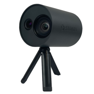
The decision was therefore made to use the XVS vSLAM 3D scanner, manufactured by Stonex. This next-generation scanner uses Visual SLAM technology coupled with an IMU sensor to collect photogrammetric data in motion.
XVS uses a proprietary algorithm that, not only selects the best photos from the hundreds collected during the survey, but also exploits visual SLAM technology to estimate the position and trajectory of the instrument using the IMU sensor.
The use of XVS is very simple because the scanner is portable, lightweight and can be used by a single operator. It is used in conjunction with a tablet with a dedicated application installed that helps during scanning by providing a real-time preview of the collected data.
Results
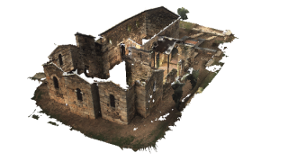
The result obtained by XVS was a very detailed and photorealistic point cloud that allowed all the various features of the historical road surface to be distinguished.
The 3D cloud was integrated with GNSS and Total Station data to georeference the entire area in detail. The need to georeference the survey in a solid manner stems from the fact that the development of the survey area is very complex, and in this way the drifts typical of IMU systems are strongly contained.
The processing of the cloud carried out with the Cube-3d and PointCAB software, also distributed by Stonex, coupled with the referenced data, made it possible to produce sections, profiles, plans and elevations compatible with various software (including CAD), as well as the extraction of very sharp orthophotos in which details can be appreciated.
In conclusion, the XVS scanner proved invaluable in being able to collect accurate and detailed (as well as georeferenced) data in a short time and with the employment of few staff. The speed of data collection and the ease of data processing allowed the professionals involved to deliver the documents requested by the client in a short time and cost-effective manner, guaranteeing accurate documentation to ensure the restoration of the historical mantle once the excavation work had been carried out.
Do you have questions about this case study?
Get in touch with Stonex, and they would be happy to answer any questions you have about pricing, suitability, availability, specs, etc.
Related articles


![Do-Giant-Tortoises-Make-Good-Neighbors-1[1].jpg](https://cdn.geo-matching.com/vRMO2Edp.jpg?w=320&s=a6108b2726133ff723670b57bc54c812)


