The Advantages of Using USVs and Multibeam Echosounders in Hydrographic Surveys
Through the collaboration between Teledyne Technologies (Teledyne) and Maritime Tactical Systems (MARTAC), a new integrated solution for the marketplace now exists. This system allows the easy collection and processing of data utilizing world-leading sensors and software with unparalleled efficiency on a state-of-the-art unmanned surface vessel. With this single-source solution, users can achieve high-accuracy data for real-time analysis, providing quick responses with fewer resource requirements.
The platform for the solution is the MARTAC Mantas T12 unmanned surface vessel, housing a Teledyne SeaBat T20 Multibeam Echosounder mounted to the underside of the T12 and the Teledyne Optech CL-360M Lidar mounted to the T-12 topside A-Frame. All components are interfaced to the onboard Mantas computer, which includes the T12 Command and Control Software. For data acquisition and post-processing, Teledyne PDS multipurpose software and CARIS Onboard Post-Processing software were used. All systems were controlled remotely from a secondary manned vessel.
Hydrographic Surveying for Navigation, Construction, Defense and Security Purposes
Near-shore hydrographic surveying can be a challenging task especially if the conditions are not ideal to collect the required data. Whenever a survey is being conducted, be it for civilian purpose, to determine the safety of navigation, support construction and infrastructure management, aid scientific research, or for Defense and Security to support search and rescue, situational awareness, threat detection and monitoring, the survey platforms typically involve multiple integrated sensors operating simultaneously and a manned vessel operated by personnel. Advances in technology mean that sensors can operate with incredible coverage and precision from a remotely operated platform creating a complete real-time autonomous solution for near-shore surveys.
Through the collaboration between Teledyne Technologies (Teledyne) and Maritime Tactical Systems (MARTAC), a new integrated solution for the marketplace now exists. This system allows the easy collection and processing of data utilising world-leading sensors and software with unparalleled efficiency on a state-of-the-art unmanned surface vessel. With this single-source solution, users can achieve high-accuracy data for real-time analysis, providing quick responses with fewer resource requirements.
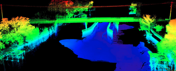
This solution was recently applied in a combined survey undertaken in the joint Teledyne and MARTAC live online demonstration from Black Creek, south of Jacksonville, Florida, in July 2020. A high-density Multibeam Sonar sensor was paired with a high-density laser scanning system (Lidar) in addition to the supporting inertial positioning system and sound-speed sensors on an unmanned surface vessel, designed to deliver real-time high-quality data.
Adding a USV to the Strategy
The platform for the solution is the MARTAC Mantas T12 unmanned surface vessel, housing a Teledyne SeaBat T20 Multibeam Echosounder mounted to the underside of the T12 and the Teledyne Optech CL-360M Lidar mounted to the T-12 topside A-Frame. All components are interfaced to the onboard Mantas computer, which includes the T12 Command and Control Software. For data acquisition and post-processing, Teledyne PDS multipurpose software and CARIS Onboard Post-Processing software were used. All systems were controlled remotely from a secondary manned vessel.
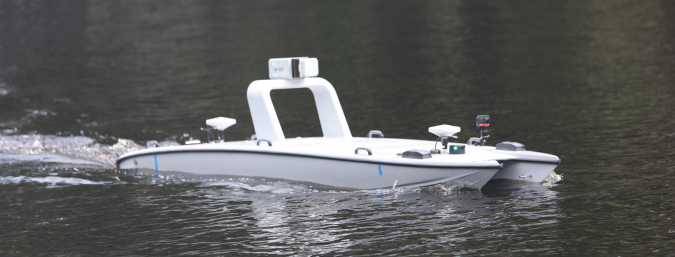
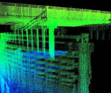
Fully loaded unmanned Mantas T12 vessel with Multibeam T20 and laser scanner CL-360 collecting synchronised and accurate 3D data from the Black Creek river
The MARTAC Mantas T12 USV enables the coverage of open ocean and littoral waterways with extended on-station persistence capability. The Mantas T12 is capable of extremely high surface speeds, and the patented catamaran hull is suitable for surface, sub-surface and unaided airdrop missions. This flexible platform can operate in fully autonomously, semi-autonomous and full operator control is designed for extended in-field operations and delivers greater mission flexibility than traditional manned systems.
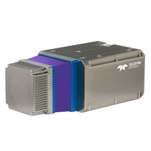
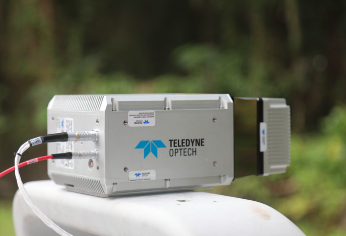
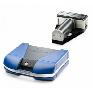
The Teledyne SeaBat T20 Multibeam Echosounder has been designed to provide exceptional acoustic performance for high-precision surveys that require minimal data cleaning and post-processing. The SeaBat T-series aim to get the user the required data cleaner, faster and more cost-effectively.
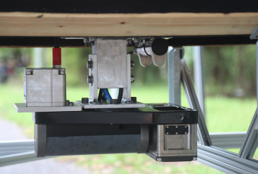
SeaBat T20 from Teledyne RESON installed on the bottom of the unmanned vessel
Built to facilitate a wide range of hydrographic tasks, the SeaBat T-series offers several data management tools. Both the user interface and the sonar are fully user-configurable, or the user can select the intelligent Tracker Autopilot and maintain focus on other tasks at the same time. Data acquisition in Black Creek was acquired in exactly this mode, with the sonar adjusting its operating parameters to the optimum settings based on an ongoing real-time analysis of the data returned.
Mapping everything above the water level, the laser scanner CL-360 from Teledyne Optech is a compact, powerful, survey-grade accuracy Lidar sensor capable of collecting detailed 3D data even in the most complex environment, extending survey capabilities to combine the sea and land for the complete dataset.
Robust and solid for Marine applications (rated as IP67), the CL-360 was installed on the top part of the vessel, shooting 500,000 points per second up to 775 m range, capturing a high-density 3D point cloud even from far away. A highly detailed, fast scanning sensor, the CL-360 saves time in field operations.
CL-360 laser scanner from Teledyne Optech collecting topographic data from the MARTAC Mantas T12
CL-360 is easy to install, Plug & Play with Teledyne PDS software and is fully compatible with CARIS HIPS and SIPS and Onboard software for post-processing and data analysis.
Hydrographic Data Acquisition
Teledyne PDS software is designed to efficiently create high-quality, fast results, whether for laser and Multibeam surveys, Singlebeam surveys, construction or dredging work. The acquisition of the Teledyne Optech CL-360 laser scanner and the Teledyne RESON SeaBat T20 data was supported via integrated drivers inside Teledyne PDS, enabling the surveyor to control all acquisition components from one piece of software.
Teledyne CARIS Onboard is a near real-time data processing software that enabled the rapid generation of processed datasets during the survey. CARIS Onboard utilises a pre-defined processing workflow which, in this case, was designed to process all data from the Lidar and SONAR, producing a grid that was transmitted via the CARIS web service on the survey platform back to the operators on the manned vessel. As the survey progressed and new data was added, CARIS OnBoard automatically processed and added to the gridded surface. The live streaming capability of OnBoard enabled the operators to maintain a consistent view of the data quality and make operational decisions as the survey progressed. Transmission of raw data volumes can be constrained by cost and bandwidth availability.
With CARIS OnBoard, the raw data was compressed to a processed surface and using the CSAR gridding technique; the ongoing survey results were able to be transmitted in order of kilobytes rather than the Gigabytes of the whole dataset. The efficient data management principle behind CARIS OnBoard helps torealisee the full benefit of remote survey operations using the solution presented here by being able to provide a final data product during the survey.
Accurate 3D visualisation Assists Operators with Remote Access to Real-Rime Survey Operations
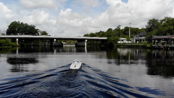
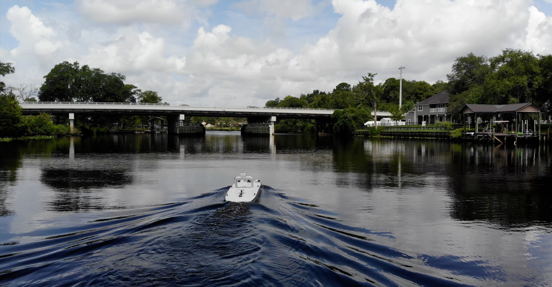
For this demonstration, a complete dataset along the river between the two bridges in the Black Creek area (around 6 km) was collected in less than one hour, including both sides of the two bridges, delivering a large volume of detailed data from the river floor and the shoulders.
The combined USV, Lidar and sonar hardware solution improves the productivity and efficiency of a marine near-shore hydrographic survey. It significantly reduces deployment time compared to manned vessels, supports rapid response and deployment, and the USV can be deployed from multiple locations such as shoreside, surface Ship or subsurface. The flexibility of this system enables surveys in areas not easily accessible by traditional manned survey vessels, such as shallow water or underneath low objects and structures.
''A complete dataset along the river between the two bridges in the Black Creek area (around 6 km) was collected in less than one hour, including both sides of the two bridges.''
Teledyne software provides accurate 3D visualisation to assist operators with remote access to real-time survey operations allowing operational decisions from any location, saving time and money, and ensuring a safer work environment.
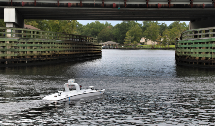
Photo from the survey approaching one of the bridges.
Teledyne software solutions allow collected data to be quickly processed into informative products to direct construction activities and provide a scalable database to manage the increasing volumes of collected high-resolution data. Automated processing systems allow products to be derived during the survey with minimal user interaction, reducing training needs and providing the information that matters when it matters.
By leveraging a suite of integrated Teledyne during and after data collection to produce products and services, surveyors can maximise their efficiency both during and after data collection to produce extremely high-quality data sets for their end users. Combined with the MARTAC USV it can lower the cost of operations by reducing the number of required personnel to operate and shortening the delivery time.
Do you have questions about this case study?
Get in touch with Teledyne Marine, and they would be happy to answer any questions you have about pricing, suitability, availability, specs, etc.


![3月21日-封面[1].jpg](https://cdn.geo-matching.com/voeE1ywo.jpg?w=320&s=6b3b1a0215d770f8797653e9202a8f52)


