Teledyne PDS
Developed to solve the variety of challenges that arise from each specific task.
Teledyne PDS is off-the-shelf software which is developed to solve the variety of challenges that arise from each specific task in the main business segments served by Teledyne Marine.

Teledyne Marine
Daytona Beach, US
Description
Teledyne PDS is of-the-shelf software and developed to solve the variety of challenges that arise from each specific task in the main business segments served by Teledyne Marine.
Do you have questions about this product?
- Questions about price, availability, and/or retailers
- Questions about technical specifications and usage
- Questions about suitability for your project or application
Specifications
-
Hardware/software requirements
-
RAM [GB]
4
HD [GB]
500
Use of GPU
N
Processor
[]
Stereo Display
N
Stand-alone
Yes
-
Other
-
Support
Online, Phone, User meeting, ...
Training
Y
Typical applications
Visualization; Editing; Plotting; Statistics
Distinguishing features
Free viewer of point cloud data sets; combined editing with grid models and CUBE; implicit 4D editing
-
Files and Registering
-
Input formats
PDS, XYZ, XTF, S7k, All, RDF, SON, JSF, MST, ...
Output formats
PDS, XLS, All, CSV, ASCII, XTF, S7k, SDS, GSF, ...
Geo-referencing
Y
Automatic Target Detection
N
Stitching multiple scans
N
-
Pre-processing and Automatic Filtering
-
Image matching facilities
N
Frequency domain decoding for data reduction
No
Removal of individual outliers
Y
Removal of vegetation
N
Removal of buildings
N
Bare ground DEM generation
Y
-
Manual Measurements
-
3D Coordinates extraction
Y
Length and Height
Y
Angle
Y
Distance
Y
Area
Y
Volume
Y
-
Interoperability
-
CAD software
AutoCAD, Microstation,
Hydrological software
No
Assigning colour from imagery to points
N
Image overlay on TIN
Y
Integration with other data types
DXF, 3Ds, SKP
-
General
-
Year of last update
2015
Year of initial introduction
2008
Modules
Editing module is availabe in: Multibeam Survey and Processing/Charting; Singlebeam Survey and Processing/Charting; Magnetometer Survey and Processing/Charting; Bar Sweep Survey; MotionScan
Source of Point Clouds
Airborne Lidar, Indoor TLS, Outdoor TLS
Supported Systems
Multibeam, Singlebeam, Laserscanner, Motion, Heading, Position, Heave, Tide, SV, SVP, Depth, ...
-
Analysis
-
Line of sight
Y
Aspect and slope
Y
Individual tree heights
N
Simulation facilities
Port Entrance Simulation; PDS Simulator
Time series analysis
Y
-
Automatically Generated Products
-
Regular Grid DEMs
Y
Cross sections
Y
TIN
Y
Contour Lines
Y
Break lines
Y
Boundary detection of solids
Y
Building footprints
N
Building roofs
N
3D City modelling
No
-
Solid Modelling
-
Lines
N
Planes
N
Cubes
N
Spheres
N
Cylinders
N
NURBS
N
Industrial features
Pipes
Earth surface features
No
Documents
Other documents
-
Product Manual (17)25.72 MB
-
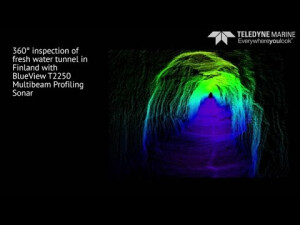
High resolution structural inspection offlooded tunnel using BlueView T2250 360°Multibeam Profiling Sonar and Teledyne PDS1.01 MB
Videos
