
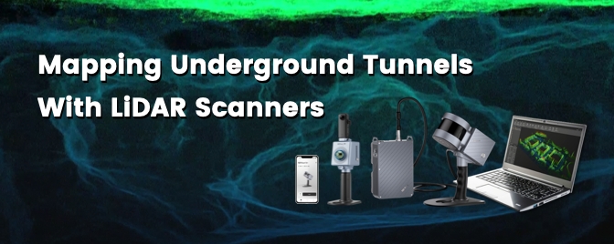
Navigating the Depths: The Power of Handheld Laser Scanners in Underground Tunnel Mapping
Underground caverns, subterranean pathways - natural or fabricated, these spaces beneath our feet have existed for almost as long as humans have roamed the earth. As we navigate the complexities of what lies below the surface, understanding how to effectively monitor and safeguard these spaces becomes paramount. We will explore how far technology has come over the ages, and how tools like handheld laser scanners have made mapping the underground easier, faster, and safer.
Before advanced sensors and technology became more commercially available, manual measurements with tape measures and a headlamp were the norm. Later, precise instruments like theodolites and distance meters, as well as new technologies like ground-penetrating radar (GPR), electromagnetic location (EML), and, the tool of the hour, SLAM-empowered scanners made their way into surveying the underground. Methods that go beyond 2D drawings like photogrammetry and 3D point cloud modelling also became more accessible, while comprehensive BIM models are also implemented as a standard to monitor data above and below the surface of the ground.
One of the most notable advancements that influenced subterranean mapping is the use of LiDAR (Light Detection and Ranging) scanners, which offer a multitude of benefits for mapping underground environments:
Real-time detection and progress monitoring: Handheld laser scanners, equipped with Simultaneous Localization and Mapping (SLAM) technology, provide real-time data acquisition. This ensures accurate monitoring of tunnel structures, allowing operators to stay informed and in control of the construction progress or as-built conditions.
Faster volume calculation and dimensional measurement: Handheld laser scanners facilitate precise volume calculations and distance measurements. Rapid dimensional measurements of cavities, including corridor width and height, contribute to efficient and detailed mapping, which is particularly valuable for infrastructure and construction projects.
Seamless digitization and data management: Handheld laser scanners excel in capturing high-resolution, three-dimensional data, allowing for the creation of detailed and accurate digital models of tunnel structures. A quick mesh model allows operators to visualize the underground space, measure, and calculate dimensions for more effective management.
High operational flexibility: Handheld laser scanners work in environments where GPS or GNSS signals are not accessible, expanding their utility to underground spaces and other GPS-denied areas. Moreover, scanners often have the option of integrating with an RTK rover to produce georeferenced measurements, enabling the generation of highly accurate 3D maps of the environment.
Applications and use cases
The benefits of laser scanning have significantly transformed the way spatial data is captured in underground environments. This has led to improved safety, efficiency, and decision-making in various industries. Let's take a look at some real-world applications.
Gold mine in Jiangxi, China
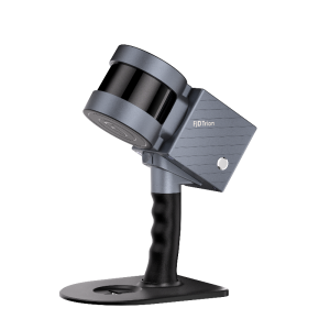
A client in China's Jiangxi Province leveraged 3D data generated using the FJD Trion S1 for real-time monitoring, progress tracking, safety hazard identification, volume calculations, and distance measurements within the underground mine space.
This digitalization is essential for ensuring efficient and safer mine operations, as well as for complying with regulatory requirements. The use of advanced technologies such as LiDAR scanners enable the rapid and accurate mapping of underground environments, providing detailed spatial data that is essential for various applications, including safety inspections, infrastructure planning, and ongoing mine operations, allowing for better decision-making, improved safety, and optimized production cycles.
Japan - digitized tunnel models for repairs and maintenance
In Hokkaido, Japan, our client sought an innovative approach to streamline regular maintenance for an aging tunnel. Before incorporating the FJD Trion S1 scanner into their workflow, the tunnel's digital documentation relied on camera drones. However, these drones fell short in providing the comprehensive 3D data and thickness required for a thorough tunnel model.
Opting for the handheld SLAM scanner, the client aimed to enhance their data capture capabilities, ensuring a more detailed representation of the tunnel's structure. The FJD Trion S1 emerged as the ideal solution, offering a cost-effective, user-friendly setup and operation process. Its accurate and colorized data output enabled the client to identify and assess gaps as small as 5-10cm, empowering them to monitor the tunnel's condition comprehensively and efficiently flag any areas of concern throughout its lifecycle.
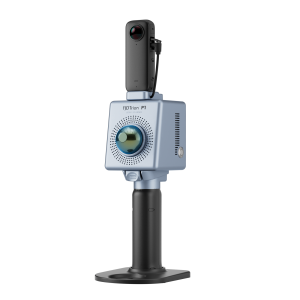
Belgium - A 3D Inventory of Quarries
An over 2000 ㎡ section of old sandstone mines located in the community of Riemst, Flanders, Belgium, was scanned using the FJD Trion P1 in less than 15 minutes. The flexibility and efficiency of the solution enabled the client to prove that the use of P1 could be a viable option for larger scale operations in digitizing tunnel records.
The 3 main reasons to digitize these tunnels are:
An accurate inventory and digital records can help municipalities with effective governance and urban planning. Detailed topographical maps that contain the locations, dimensions, and interconnections of tunnels, provide a comprehensive overview for municipal authorities. They can also easily refer to the conditions of tunnels to assess potential risks and prioritize maintenance or conservation efforts.
Integrating the laser scans with surface-level geographical data allows for comprehensive analysis. For instance, it enables the detection of structures, such as a house or road, positioned directly above an underground mine. This information empowers proactive measures within the mine, such as stabilization efforts or the construction of supportive structures, to prevent potential stability issues or the risk of collapse for the overlying structures, such as houses or roads.
Heritage preservation. Detailed digital maps can capture the intricate details of mining structures, equipment, and landscapes. Historical artifacts and features within mines can be digitally preserved in their original context, providing a virtual archive for education, research, and even virtual tours.
Final Thoughts
In the ever-evolving landscape of mining and tunneling, the integration of handheld laser scanners marks a significant leap forward. These devices, with their real-time capabilities, safety enhancements, and precise measurements, empower professionals to navigate the complexities of underground spaces with confidence. As industries continue to prioritize digitization and safety, the adoption of SLAM-based handheld laser scanners is poised to be a game-changer. Embrace the future of underground mapping with these cutting-edge technologies.
Head over to this guide to learn how to choose a scanner that fits your needs.
A handheld solution like the FJD Trion S1 is a versatile option that prioritizes scanning efficiency with a range of up to 120 m and compatibility with an RTK receiver for geo-referenced point cloud and a 360 camera for colorized models.
The lightweight and compact FJD Trion P1 is about the same size and weight as a large water bottle. While its footprint is small, no compromises were made in making it a powerful tool to capture crisp point clouds, even colorized ones.
Do you have questions about this case study?
Get in touch with FJDynamics, and they would be happy to answer any questions you have about pricing, suitability, availability, specs, etc.


![Do-Giant-Tortoises-Make-Good-Neighbors-1[1].jpg](https://cdn.geo-matching.com/vRMO2Edp.jpg?w=320&s=a6108b2726133ff723670b57bc54c812)


