
GNSS RTK Workflow with DJI Enterprise and Autel UAVs Using LOCAL NTRIP
In the realm of drone surveying, accuracy is the cornerstone of successful data collection. Among the diverse array of tools available to enhance surveying precision, GNSS receivers play a pivotal role. In this ecosystem, the new METTATEC X5R PLUS GNSS receiver with LOCAL NTRIP offers clear advantages in the field, compared to other GNSS products on the drone market such as the DJI D-RTK 2 GNSS receiver and other receivers. In this article, we will explore the advantages of the X5R PLUS with LOCAL NTRIP service in terms of versatility when used with DJI Enterprise and Autel RTK brand drones.
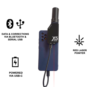
Precision Redefined - The X5R Plus GNSS Receiver with LOCAL NTRIP Service for UAVs
1. Hyper-Local Correction Data:
The X5R PLUS equipped with LOCAL NTRIP service harnesses the power of real-time correction data. The main advantage here is that this correction data is delivered from the X5R PLUS like a base station situated in close proximity to the drone's operating area. This minimizes errors stemming from atmospheric disturbances and geographical factors, resulting in unparalleled centimetre-level accuracy. This level of precision is essential for high-resolution mapping and surveying projects.
2. Real-Time Accuracy:
LOCAL NTRIP service facilitates continuous real-time corrections, enabling the drone to adjust its positioning instantaneously. This is particularly advantageous when surveying dynamic landscapes or structures, as the corrections adapt to changing conditions, ensuring data integrity throughout the flight.
3. Very easy configuration of the LOCAL NTRIP service
To start the LOCAL NTRIP service with the X5R PLUS, it is only necessary to indicate the "LOCAL NTRIP" operating mode in Mettatec´s FindX5 App configuration application.
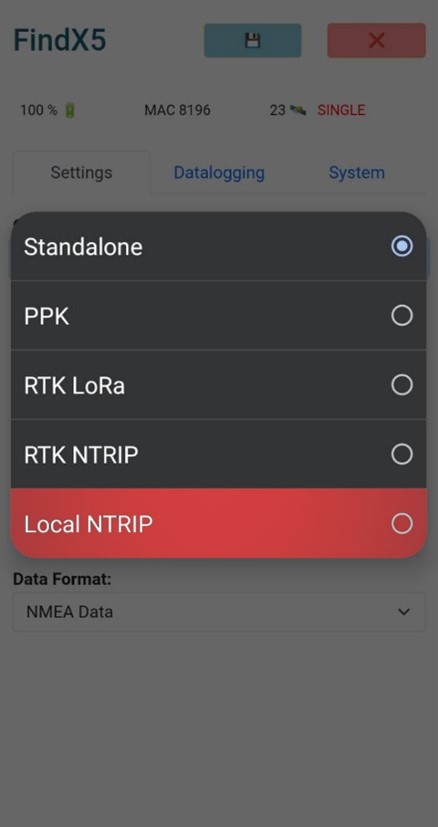
Operation modes in FindX5 App.
4. Great Compatibility and Easy Connection:
Ensuring perfect compatibility and easy connection between an RTK drone and the X5R PLUS GNSS receiver that offers the NTRIP LOCAL service is essential for efficient survey operations. To establish the connection, start by connecting the drone to the Wi-Fi of the X5R PLUS. This connection ensures smooth wireless communication. Once paired, configure in the drone's control and configuration interface, in the RTK data section, the connection parameters needed to use the NTRIP LOCAL service, such as IP address, port, mount point and login credentials session. Convergence of compatibility and an easy-to-use setup method makes connecting an RTK drone to the X5R PLUS an essential component of any professional drone survey workflow.
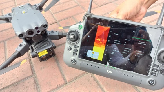
RTK Fix with the Dji Matrice 30T and the X5R PLUS GNSS
5. Customization Potential:
One of the standout features of the X5R PLUS is the flexibility they provide in establishing custom base stations. This empowers users to tailor correction data to their specific requirements, making it an ideal solution for projects with unique spatial demands.
The Case of the DJI D-RTK 2 for DJI Enterprise Drones: Limited Versatility
1. Restricted to DJI Ecosystem:
The DJI D-RTK 2 GNSS receiver is purpose-built for DJI drones, aligning seamlessly with the DJI ecosystem. While this integration streamlines compatibility for existing DJI users, it limits the receiver's applicability to non-DJI platforms, restricting professionals who work with a diverse range of drone models.
2. Exclusivity Hinders Multitasking:
Unlike more versatile GNSS receivers, the D-RTK 2 is tailored primarily to enhance drone positioning accuracy within the DJI ecosystem. This means it cannot be easily repurposed for other data collection activities that professional GNSS receivers commonly support, such as ground-based surveying, machine control, and geodetic measurements.
3. Limited Professional Features:
Compared to specialized professional GNSS receivers, the D-RTK 2 lacks certain advanced features that are integral for comprehensive surveying tasks. This includes the absence of certain data collection modes, geodetic coordinate system support, and more advanced data output options.
The case of the Autel EVO II RTK drone: Cost-effective and efficient solution
Utilizing the affordable GNSS receiver X5R PLUS with LOCAL NTRIP service to transmit RTK data to the Autel EVO 2 RTK drone presents significant advantages for precision surveying tasks. The affordability of the GNSS receiver minimizes upfront investment while maintaining the capability to achieve centimetre-level accuracy. To configure the LOCAL NTRIP service on the remote-control interface, you need to input the appropriate NTRIP caster details, including the caster's IP address or domain name, port number, mount point, username, and password. The integration of the X5R PLUS with LOCAL NTRIP service not only enhances surveying precision but also streamlines workflows, making it a cost-effective and efficient solution for geospatial data collection tasks with the EVO 2 RTK and other RTK drones of Autel.
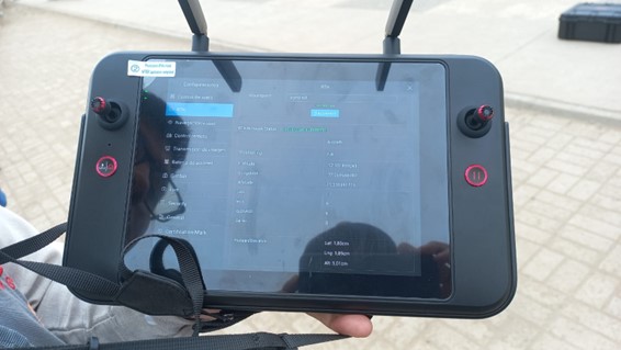
RTK Fix with the Autel EVO 2 Pro RTK and the X5R PLUS GNSS
Choose Wisely: Precision and Versatility
When considering GNSS receiver options for drone surveying, professionals must weigh the advantages of accuracy and versatility. GNSS receivers with the LOCAL NTRIP service stand out for offering unmatched accuracy and customization potential for drone surveying, especially in situations that demand the highest precision.
However, in the case of the DJI D-RTK 2 GNSS Receiver, while improving accuracy within the DJI ecosystem, falls short when it comes to the broader spectrum of data collection activities that professional GNSS receivers can support. It's unique compatibility and limited feature set may not align with the requirements of professionals looking for a more versatile tool for various survey tasks.
While the DJI D-RTK 2 GNSS receiver serves as a valuable asset in improving positioning accuracy in the field of DJI-branded drones, its limitations in terms of compatibility and versatility deserve careful consideration. For professionals looking to expand their horizons beyond drone-specific tasks, the X5R PLUS GNSS receiver with LOCAL NTRIP service offers the accuracy, versatility, and customizability needed to address a broader range of geospatial challenges.

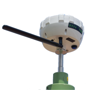
The X5R Plus GNSS Receiver in LOCAL NTRIP mode.
Do you have questions about this case study?
Get in touch with METTATEC, and they would be happy to answer any questions you have about pricing, suitability, availability, specs, etc.


![Do-Giant-Tortoises-Make-Good-Neighbors-1[1].jpg](https://cdn.geo-matching.com/vRMO2Edp.jpg?w=320&s=a6108b2726133ff723670b57bc54c812)


