


VZ-600i
Extremely Versatile High Performance 3D Terrestrial Laser Scanner
RIEGL‘s latest generation of professional Terrestrial Laser Scanners stands out with extreme versatility, high productivity, ultimate performance and additional mobility – providing an excellent return on investment!

RIEGL | Innovation in 3D
Horn, AT
Description
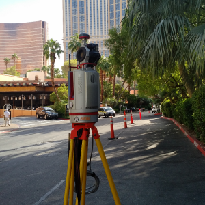
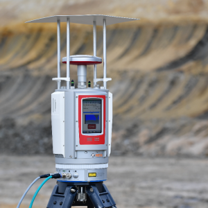
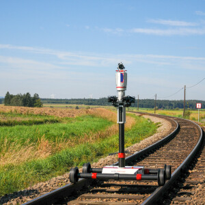
The RIEGL VZ-600i offers a broad range capability from 0.5 m up to 1000 m and is suitable for indoor and outdoor 3D mapping applications. 3D position accuracy of 3 mm, less than 30 sec scan time for high-resolution scans with 6 mm point spacing at 10 m, enabling more than 60 scan positions/hour with real-time registration, weight less than 6 kg (13 lbs), 2.2 MHZ PRR, three internal cameras & GNSS integrated, and also prepared for mobile mapping applications – these key features will speed up your workflow in indoor and outdoor applications like AEC (Architecture, Engineering, Construction), BIM (Building Information Modeling), as-built surveying, forensic and crash scene investigation, archeology & cultural heritage documentation, forestry, and many more.
Do you have questions about this product?
- Questions about price, availability, and/or retailers
- Questions about technical specifications and usage
- Questions about suitability for your project or application
Specifications
-
Application
-
Training facilities
Yes
Main users
• Surveyors • architects • civil engineers • plant design engineers • archeology
Distinguishable features
• broad range capability (0.5 m up to 1000 m) • 5 sec scan time for low resolution overview scans • 30 sec scan time for 6 mm resolution @ 10 m distance • 60 scan positions per hour (with image acquisition) • 3D position accuracy up to 3 mm @ 50 m • high laser pulse repetition rate of up to 2.2 MHz • scan speed up to 420 lines/sec • eye safe operation at Laser Class 1 • precise real-time onboard registration • internal cameras (offering optional on-board face detection and automatic facial blurring in real-time before image storage) • internal GNSS receiver / external RIEGL GNSS RTK receiver (optional) • optional external system camera or panorama camera • weight 6 kg / 13 lbs • prepared for mobile use
Main applications
• As-Built Surveying • Architecture & Facade Measurements • Civil Engineering • Building Information Modeling (BIM) • City Modeling • Forensics & Crash Scene Investigation • Emergency Management Planning • Archeology and Cultural Heritage Documentation • Tunnel Surveying • Forestry • Research
-
Peripherals
-
External Camera
Y
Export formats of camera image
JEPEG, TIFF, RAW
User interface
integrated touchscreen, tablet, PC
Specifications
Windows, iOS, Android, Linux
Additional sensors
orientation sensors (MEMS), GNSS Receiver. SyncTimer, Laser Plummet
Registration/orientation methods
real-time, control/ tie Points, backsight, overlapping surfaces
-
Operation Characteristics
-
Operating temperature: min. [°C]
-20
Operating temperature: max. [°C]
40
Humidity range [%]
80
Internal Camera
Y
Control panel built in
Y
IP Rating
64
Dual Axis Compensation
Y
-
Scanning Characteristics
-
Max. vertical field of view [deg]
105
Max. horizontal field of view [deg]
360
Min. horizontal step size [deg]
0.0015
Min. vertical step size [deg]
0.0007
Uncertainty of horizontal step size [deg]
0.0005
Uncertainty of vertical step size [deg]
0.0007
Beam deflection mechanism
rotating polygon mirror, rotating head
Max. measurement rate [kHz]
2200
-
Software Functionality
-
Software name
RiSCAN PRO
Automatic detection of tie points
Y
Real time visualization during scanning
Y
Geo-referencing
Y
Fitting of primitives
Y
Specification of primitives
lines, planes
-
Laser Ranger
-
Range measurement principle
pulse
Laser safety classification
1
Min. Range [m]
0.5
Max. Range [m]
1000
Range uncertainty (constant part) [mm]
5
Beam diameter at exit [mm]
0.35
-
Power
-
Battery type
internal
Scan time per battery [h]
1.5
-
General
-
Year of introduction
2022
Height [m]
0.305
Depth [m]
0.184
Width [m]
0.173
Total Weight [kg]
< 6
Documents
Brochure
datasheet_vz-600i
Other documents
-
Applicationsheet Forestry & Agriculture.pdf3.41 MB
-
RiPANO Brochure.pdf3.61 MB
Videos


