VQ-680 OEM
High-Performance Online Waveform Processing Airborne LiDAR Scanning Module for Integration with Third-Party Camera Systems
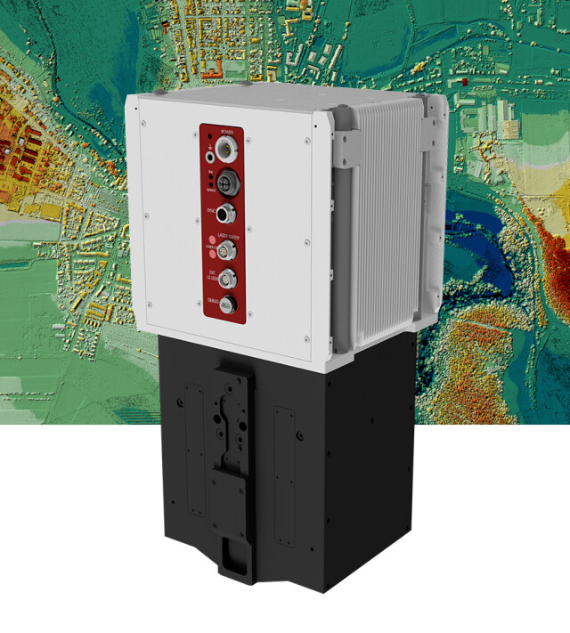
The VQ-680 OEM is a compact airborne LiDAR scanner module designed for integration with large-format photogrammetric aerial camera systems that are configured for urban mapping applica tions. The VQ-680 OEM’s form factor has been optimized to provide a compact scanner with a small exit aperture, given the limited space in, e.g., photogrammetric oblique camera configurations.

RIEGL | Innovation in 3D
Horn, AT
Description
The VQ-680 OEM is a compact airborne LiDAR scanner module designed for integration with large-format photogrammetric aerial camera systems that are configured for urban mapping applications. The VQ-680 OEM’s form factor has been optimized to provide a compact scanner with a small exit aperture, given the limited space in, e.g., photogrammetric oblique camera configurations.
The LiDAR scanner module includes an innovative scanning mechanism that provides forward, nadir, and backward scan lines at +20/+10/0/-10/-20 degrees in the flight direction. In combination with a wide horiontal field of view of 60 degrees a regular point spacing for each viewing direction is generated, enabling exceptional coverage of vertical structures such as building facades, as well as coverage at the bottom of narrow street canyons with little to no shadowing.
The operational envelope ranges from typical flying altitudes of 1000 m AGL at a pulse repetition rate of 2.4 MHz (~ 24 pts/m2 at 120 kts), up to 2300 m AGL at a PRR of 300 kHz for targets with reflectivity in excess of 20%. Electrical interfaces comprise of a power supply, PPS and NMEA time synchronization, and a laser safety connector. Scan data is stored on an external PC via Gigabit Ethernet, which is also used for configuring and controlling the laser scanner via RiACQUIRE, RIEGL‘s versatile data acquisition software featuring a GUI, real-time data visualization and remote control capabilities.
A sturdy mechanical interface enables mounting the LiDAR module inside a camera system rigidly connected with the IMU/GNSS system and various camera modules.
Do you have questions about this product?
- Questions about price, availability, and/or retailers
- Questions about technical specifications and usage
- Questions about suitability for your project or application
Specifications
-
General
-
Data storage facilities
Solid State Disc SSD, 2 TByte
Postprocessing software
RiACQUIRE, RiPROCESS, RiUNITE
Power requirements
typ. 100 W, max. 190 W
Total Weight [kg]
< 10 kg
Year of introduction
2023
-
Application
-
Main applications
Mapping of Complex Urban Environments • City Modeling • Ultra-High Resolution Mapping • Oblique Mapping of Vertical Structures • Corridor Mapping
-
Measurement Characteristics
-
Max. field of view [deg]
60
Max. number of recorded echoes per pulse
32
Max. pulse frequency [Hz]
2400000
Min. pulse frequency [Hz]
300000
Full-wave form digitization
Y
Scanning method
echo signal digitization, online waveform processing, time-of-flight measurement, multiple target capability, NFB (Nadir/Forward/Backward) scanning
-
Laser Pulse Characteristics
-
Type/class laser
Class 3B Laser Product according to IEC 60825-1:2014
Standard pulse length [ns]
3
Wavelength [nm]
1052
-
More information
-
Distinguishable features
High pulse repetition rates of up to 2.4 MHz • Up to 2 MHz measurements on the ground • Forward / nadir / backward scan directions at +20 / +10 / 0 / -10 / -20 degrees • Wide field of view of 60 degrees • Excellent atmospheric clutter suppression • Multiple target capability • Online waveform processing
-
Application areas
-
Select an application area:
Land Surveying and Cadastre, Other
Documents
Brochure
datasheet_VQ-680-OEM
Other documents
-
RiACQUIRE Datasheet.pdf4.34 MB
-
RiUNITE Datasheet.pdf1.92 MB
-
Infosheet ALS Overview.pdf4.34 MB


