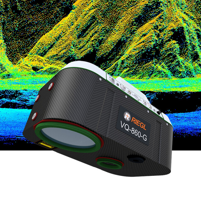
VQ-860-G
High Performance Topo-Bathymetric Airborne Laser Scanner with Online Waveform Processing and Full Waveform Recording
The RIEGL® VQ-860-G airborne laser scanner with increased performance enhances depth penetration in surveying in-land waters and near shore waters for even more efficiency in bathymetric applications. The complete system is offered with an optionally integrated and factory-calibrated INS/GNSS system and a digital camera.

RIEGL | Innovation in 3D
Horn, AT
Description
The RIEGL® VQ-860-G airborne laser scanner with increased performance enhances depth penetration in surveying inland waters and near shore waters for even more efficiency in bathymetric applications. The complete system is offered with an optionally integrated and factory-calibrated INS/GNSS system and a digital camera.
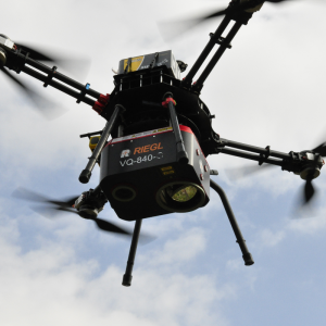
The RIEGL VQ-860-G is a compact and versatile system designed for straight forward integration on crewed aircraft. Weighing only 15 kg (33 lbs), integration into drones is also possible. Parametrization of the instrument allows high operational flexibility in order to adapt performance ideally to the survey project, with regards to the carrier aircraft‘s altitude and speed as well as the mission objective. The rugged internal mechanical structure together with the dust- and splash water proof housing enable long-term operation on airborne platforms.
The scanner carries out laser range measurements for high resolution surveying of underwater topography with a narrow, visible green laser beam, emitted from a pulsed laser source. Subject to clarity, at this particular wavelength the laser beam penetrates water enabling measurement of submerged targets on the seafloor and in the water column.
Do you have questions about this product?
- Questions about price, availability, and/or retailers
- Questions about technical specifications and usage
- Questions about suitability for your project or application
Specifications
-
General
-
Camera
digital camera (optionally integrated)
Data storage facilities
2 TB SSD
Power requirements
typ. 180 W, max. 260 W
Total Weight [kg]
<18.5 kg (with INS/GNSS and camera)
Year of introduction
2024
Postprocessing software
RiACQUIRE, RiPROCESS, RiUNITE
-
Application
-
Main applications
Coastline Cartography • Detection of Submerged and Floating Targets • Surveying for Hydraulic Engineering • Hydro-Archeological Surveying • Challenging Surveying Situations in River Mapping
-
Measurement Characteristics
-
Scanning method
rotating scan mirror
Full-wave form digitization
Y
Max. pulse frequency [Hz]
100000
Min. pulse frequency [Hz]
50000
Max. field of view [deg]
approx. 47° x 36°
-
Operation Characteristics
-
Max. flying height [m]
5600
Platform
Helicopter, RPAS (UAV/UAS)
-
Laser Pulse Characteristics
-
Type/class laser
Class 3B Laser Product according to IEC60825-1:2014
Wavelength [nm]
532
-
More information
-
Distinguishable features
large operational envelope with typical flight altitudes from 75 m to 600 m • high accuracy ranging based on echo digitization and online waveform processing with multiple-target capability • concurrent comprehensive full waveform storage of all measurements for subsequent full waveform analysis • high spatial resolution due to measurement rates of up to 100 kHz and high scanning speed of up to 100 scans/sec • INS/GNSS system and digital camera (optionally integrated) • compact and robust design • high autonomy provided by large internal storage capacity • provides operational mode with reduced laser power to adapt to eye-safety requirements in sensitive areas
-
Application areas
-
Select an application area:
Hydrography, Land Surveying and Cadastre, Other
Documents
Brochure
datasheet_VQ-860-G
Other documents
-
RiACQUIRE Datasheet.pdf4.34 MB
-
Infosheet BLS Overview.pdf1.53 MB


