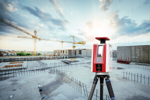

The RIEGL VZ-600i: High Speed Laser Scanning for Professionals
Extremely high speed and highest accuracy make the RIEGL VZ-600i 3D terrestrial laser scanner a most profitable tool for surveyors. Data acquisition – especially of large projects in construction, AEC and BIM – have never been so easy and fast: One scan position per minute (6mm resolution at 10m distance, 30 million points per scan, images included, on-board registration) The efficient RIEGL workflow is completed by the One-Touch Processing Wizard, which delivers a precise, high-resolution point cloud in an incredibly short time.
Products featured in this video
More from "RIEGL | Innovation in 3D"