VUX-180-24
UAV LiDAR Sensor for High-Speed Corridor Mapping
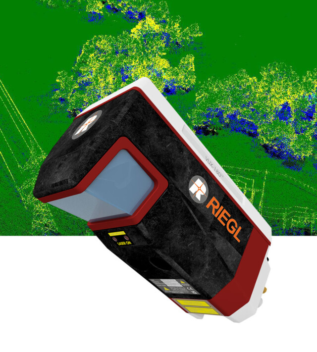
The new RIEGL VUX-180-24 is a lightweight and versatile airborne laser scanner offering a wide field of view of 75 degrees and an extremely high pulse repetition rate of up to 2.4 MHz. These features – in combination with an increased scan speed of up to 800 lines/second – make the RIEGL VUX-180-24 perfectly suited for high speed surveying missions and applications where an optimal line and point distribution is required.

RIEGL | Innovation in 3D
Horn, AT
Description
The new RIEGL VUX-18024 is a lightweight and versatile airborne laser scanner offering a wide field of view of 75 degrees and an extremely high pulse repetition rate of up to 2.4 MHz. These features – in combination with an increased scan speed of up to 800 lines/second – make the RIEGL VUX-18024 perfectly suited for high speed surveying missions and applications where an optimal line and point distribution is required.
The RIEGL VUX-18024 makes use of RIEGL's unique Waveform-LiDAR technology, allowing echo digitization and online waveform processing. Multi-target resolution is the basis for penetrating even dense foliage.
For smooth and straight forward data storage, the scanner provides an internal data storage capacity of 2 TByte and a removeable CFast® card. Interfaces for the integration of an appropriate external IMU/GNSS system and up to five optional external cameras are available.
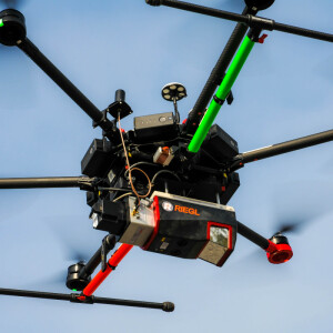
The sophisticated design of the RIEGL VUX-18024 – already proven in the RIEGL VUX-120, VUX-160, and VUX-240 series – enables smooth integration with fast-flying UAS/UAV/RPAS, small manned aeroplanes and helicopters. It is offered both, as stand-alone UAV LiDAR sensor and also in various fully-integrated UAV-based laser scanning system configurations with appropriate IMU/GNSS system and optional cameras. This allows the scanner to perfectly meet all the specific requirements of the customers' applications.
Do you have questions about this product?
- Questions about price, availability, and/or retailers
- Questions about technical specifications and usage
- Questions about suitability for your project or application
Specifications
-
Application
-
Distinguishable features
scan speed up to 800 lines/second • laser pulse repetition rate up to 2.4 MHz • measurement rate up to 2,000,000 meas./sec • operating flight altitude up to 980 m / 3,250 ft • Field of View up to 75° • compact & lightweight (2.7 kg / 5.9 lbs) • cutting edge RIEGL technology providing: - echo signal digitization - multiple target capability - online waveform processing - multiple-time-around processing • easily mountable to unmanned platforms (UAVs) and small manned aircraft • mechanical and electrical interface for IMU/GNSS integration • interfaces for up to 5 external cameras • scan data storage on internal SSD Memory • removeable CFAST® memory card
Main applications
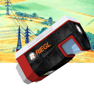
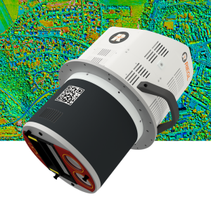
High-Speed Corridor Mapping and High-Density Applications: e.g. mapping and monitoring of critical infrastructure like power lines, railway tracks, pipelines, runways • Topography in Open-Cast Mining • Surveying of Urban Environments • Agriculture & Forestry
-
Measurement Characteristics
-
Max. number of recorded echoes per pulse
32
Scanning method
rotating polygon mirror
Max. field of view [degrees]
75
Max. pulse frequency [Hz]
2400000
Min. pulse frequency [Hz]
300000
Range accuracy [mm]
10
Scanning Speed [measurements p second]
200000000
-
Physical Properties
-
Water and dust proof
IP64
Height [cm]
13.4
Length [cm]
28.3
Weight [kg]
2.7
Width [cm]
11.7
-
Laser Pulse Characteristics
-
Beam divergence [mrad]
0.4
Laser Class
Class 3R Laser Product according to IEC60825-1:2014
Min. range of laser pulse [m]
5
Standard pulse length [ns]
3
Wavelength [nm]
1550
Max. range of laser pulse [m]
980
-
Power Supply
-
Power consumption
typ. 65 W
Power requirements
18 - 34 V DC
-
Operation Characteristics
-
Camera included
Optional
-
Data and Software
-
Type of storage
SSD
-
General
-
Year of introduction
2023
Documents
Brochure
datasheet_VUX-180-24
Other documents
-
Applicationsheet Forestry & Agriculture.pdf3.41 MB
-
Infosheet RIEGL UAV Sensors Systems.pdf4.7 MB


