
VUX-240-24
Lightweight Airborne Laser Scanner with Online Waveform Processing
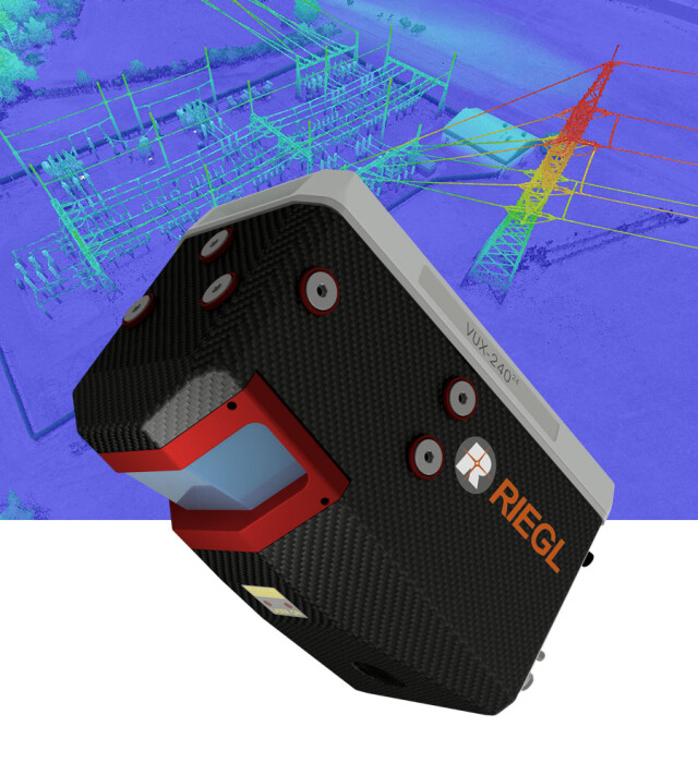
The RIEGL VUX-240-24 is the new version of the proven RIEGL VUX-240, offering higher pulse repetition rates and faster scanning speed for further increased field performance and workflow efficiency. The sophisticated design enables integration with UAS/UAV/RPAS and adequate crewed aero planes or helicopters.

RIEGL | Innovation in 3D
Horn, AT
Description
The RIEGL VUX-240-24 is the new version of the proven RIEGL VUX-240, offering higher pulse repetition rates and faster scanning speed for further increased field performance and workflow efficiency. The sophisticated design enables integration with UAS/UAV/RPAS and adequate crewed aero planes or helicopters.
With its wide field of view of 75 degrees and an extremely fast data acquisition rate of up to 2.4 MHz, the instrument is perfectly suited for high point density applications.
A continuously rotating polygon mirror wheel enables scan speeds of up to 600 lines per second, for efficiently covering large areas when operated from fast UAVs or aircraft.
The VUX-240-24 makes use of RIEGL‘s unique Waveform-LiDAR technology, allowing echo digitization and online waveform processing. Multi-target resolution is the basis for penetrating even dense foliage.
The scanner provides an internal data storage capacity of 2 TByte and is equipped with interfaces for an external IMU/GNSS system as well as to control up to four external cameras.
Do you have questions about this product?
- Questions about price, availability, and/or retailers
- Questions about technical specifications and usage
- Questions about suitability for your project or application
Specifications
-
Application
-
Distinguishable features
laser pulse repetition rate up to 2.4 MHz • measurement rate up to 2,000,000 meas./sec • scan speed up to 600 lines/second • operating flight altitude up to 1,430m / 4,700 ft • Field of View up to 75° • perfectly linear and parallel scan lines • cutting edge RIEGL technology providing: - echo signal digitization - multiple target capability - online waveform processing - multiple-time-around processing • compact & lightweight • easily mountable to unmanned plat- forms (UAVs) and to helicopters, gyro- copters, and other crewed aircraft • mechanical and electrical interface for IMU/GNSS integration (optional) • interfaces for up to 4 optional cameras • scan data storage on internal 2 TByte SSD Memory • removeable CFAST® memory card
Main applications
Corridor Mapping: Power Line, Railway Track and Pipeline Inspection • Topography in Open-Cast Mining • Surveying of Urban Environments • Archeology and Cultural Heritage Documentation • Agriculture & Forestry
-
Measurement Characteristics
-
Max. field of view [degrees]
75
Max. number of recorded echoes per pulse
30
Max. pulse frequency [Hz]
2400000
Min. pulse frequency [Hz]
300000
Scanning method
rotating polygon mirror
Range accuracy [mm]
20
multiple pulses in air
Y
Scanning Speed [measurements p second]
2000000
-
Physical Properties
-
Height [cm]
18.5
Length [cm]
29
Water and dust proof
IP64
Width [cm]
16.2
Weight [kg]
4.3
-
Laser Pulse Characteristics
-
Beam divergence [mrad]
0.35
Laser Class
Class 3R Laser Product according to IEC60825-1:2014
Max. range of laser pulse [m]
1430
Min. range of laser pulse [m]
5
Standard pulse length [ns]
3
Wavelength [nm]
1550
-
Power Supply
-
Power consumption
typ. 77 W
Power requirements
18 - 34 V DC
-
Operation Characteristics
-
Camera included
Optional
-
Data and Software
-
Type of storage
SSD
-
General
-
Year of introduction
2023
Documents
Brochure
datasheet_VUX-240-24
Other documents
-
Applicationsheet Forestry & Agriculture.pdf3.41 MB
-
RiPROCESS Datasheet.pdf3.99 MB


