VQ-840-GE
Lightweight and Compact Topo-Bathymetric Airborne Laser Scanner with Online Waveform Processing and Full Waveform Recording
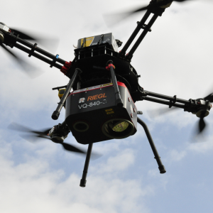
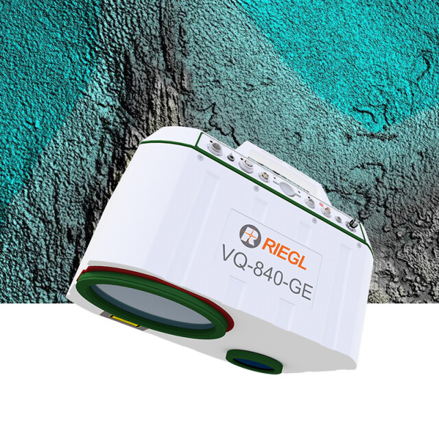
The RIEGL® VQ-840-GE is a fully integrated compact airborne laser scanner for combined topographic and bathymetric surveying. Its compact and very lightweight design facilitates integration into UAVs. The system can be offered optionally with an integrated and factory-calibrated INS/GNSS system and an optional camera.

RIEGL | Innovation in 3D
Horn, AT
Description
The RIEGL® VQ-840-GE is a fully integrated compact airborne laser scanner for combined topographic and bathymetric surveying. Its compact and very lightweight design facilitates integration into UAVs. The system can be offered optionally with an integrated and factory-calibrated INS/GNSS system and an optional camera.
The scanner carries out laser range measurements for surveying of underwater topography with a narrow, visible green laser beam, emitted from a pulsed laser source. Subject to clarity, at this particular wavelength the laser beam penetrates water enabling measurement of submerged targets.
The distance measurement is based on the time-of-flight measurement with very short laser pulses and subsequent echo digitization and online waveform processing. The laser beam is deflected in an elliptic scan pattern and hits the water surface at an incidence angle with low variation.
The VQ-840-GE can be complemented with an inertial navigation sensor for subsequent estimation of the instrument’s location and orientation. As further option a high-resolution digital camera can be integrated to supplement the data gained by the laser scanner.
The rugged internal mechanical structure together with the dustand splash water proof housing enables long-term operation on airborne platforms, especially UAVs.
Do you have questions about this product?
- Questions about price, availability, and/or retailers
- Questions about technical specifications and usage
- Questions about suitability for your project or application
Specifications
-
General
-
Camera
integrated digital camera (optional)
Data storage facilities
2 TB SSD
Power requirements
typ. 110 W, max. 220 W
Total Weight [kg]
9.5
Year of introduction
2024
Postprocessing software
RiACQUIRE, RiPROCESS, RiUNITE
-
Application
-
Main applications
Coastline and Shallow Water Mapping • River Surveying • Repeated Survey of Water Reservoirs
-
Measurement Characteristics
-
Full-wave form digitization
Y
Max. pulse frequency [Hz]
50000
Scanning method
rotating scan mirror
Max. field of view [deg]
approx. 47° x 36°
-
Operation Characteristics
-
Platform
Helicopter, RPAS (UAV/UAS)
Max. flying height [m]
5600
-
Laser Pulse Characteristics
-
Type/class laser
Class 3B Laser Product according to IEC60825-1:2014
Wavelength [nm]
532
-
More information
-
Distinguishable features
lightweight 9.5 kg (21 lbs) • designed for combined topographic and bathymetric UAV-based survey • high accuracy ranging based on echo digitization and online waveform processing with multiple-target capability • concurrent comprehensive full waveform storage for all measurements • high spatial resolution due to measurement rate of up to 50 kHz and high scanning speed of up to 100 scans/sec • integrated inertial navigation system (optional) • integrated digital camera (optional) • compact, lightweight and robust housing compliant with stabilized platforms
-
Application areas
-
Select an application area:
Oceanography, Land Surveying and Cadastre, Other
Documents
Brochure
datasheet_VQ-840-GE
Other documents
-
RiACQUIRE Datasheet.pdf4.34 MB
-
Infosheet BLS Overview.pdf1.53 MB


