
Teledyne Geospatial Is Formed by the Merger of Teledyne Optech and Teledyne CARIS
Teledyne Optech and Teledyne CARIS have united to form Teledyne Geospatial in response to the evolving marketplace needs. Under the Teledyne Imaging group, the harmony between the two business units was clear and the two teams were brought together to offer added value to customers through solutions across hardware, software and workflows.
Andy Hoggarth, vice president of sales and marketing at Teledyne Geospatial, has been with Teledyne CARIS for almost 20 years. Having begun his geospatial career as a Multibeam sonar processor using CARIS software at sea, he transitioned from working on the technical side of the business and is considered an expert in ocean mapping. Teledyne CARIS has carved out a solid niche within the marine sector, only to become broader via this new collaboration. For Hoggarth, the synergies were clear: fusing the two companies reflects the natural evolution of the geospatial industry.
New opportunities for customers
“What’s new about this model is our ability to streamline and centralise our service provision, offering more to both new and existing customers across the spectrum of needs,” comments Hoggarth. “Having a single contact point across all requirements means efficiency gains in workflow, saving time and ensuring our customers get what they need earlier. The needs of professionals are evolving to no longer focus solely on land or sea, and both geospatial and maritime enterprises are increasingly expected to offer a more comprehensive suite of services. Bringing Optech and CARIS together enables leveraging the world-leading expertise of both companies, ensuring customers can take full advantage of their ability to provide targeted solutions for land, air and sea. We see new opportunities to connect existing hydrographic customers to the broader geospatial sector. We can offer solutions to a new spectrum of clients on the topographic mapping side through the latest geospatial workflow software including tools like artificial intelligence (AI).”
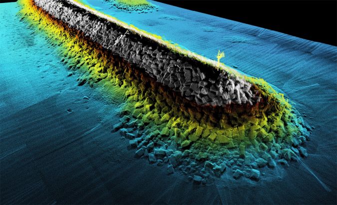
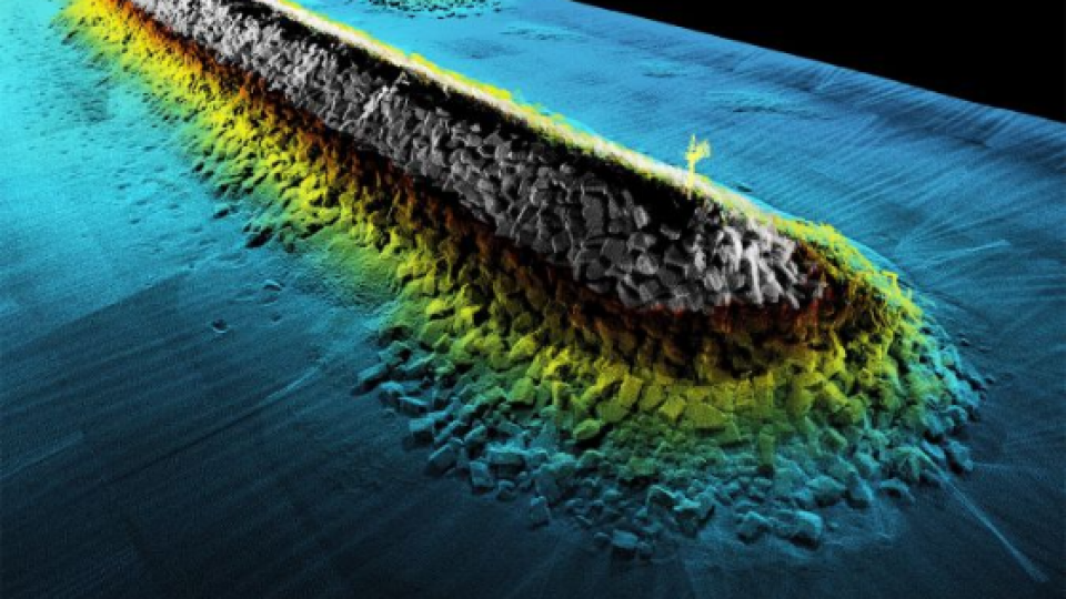
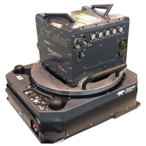
Image 1: Teledyne Geospatial provides solutions and workflows for seamlessly mapping land and sea. (Image courtesy: Dave Somers, Ocean Surveys)
Consequences of the merger for the teams
Joining forces means the teams are gaining new skills across disciplines and ensures retention of the field-specific expertise they’re known for. The market is familiar with the strong customer service and support model, from engineering to sales, and that will not change. Teledyne’s arsenal includes hydrographers, physicists, surveyors and GIS professionals, AI specialists, engineers and computer scientists. Going forward, as the market transitions to digital, the skills and expertise needed most in the field are at the intersection of traditional domain knowledge and the diverse aspects of computer science. “There is an evolution underway in the industry, and enterprises that can recruit highly skilled teams with expertise across the geospatial spectrum will be the ones to engage with,” suggests Hoggarth. “Our teams are industry professionals who understand hardware and software, and we see this as an opportunity to develop holistic solutions for hydrographic and topographic mapping.”
Delivering a competitive advantage
Teledyne Geospatial will have access to the full range of sonar, Lidar and software solutions, enabling customers to gain full value from their Teledyne investment with the most advanced sensors in both ocean and land environments. “In that respect, we are unique,” notes Hoggarth. “Whilst some providers have topographic sensors with integrated software, even bathymetric Lidar, our software workflow goes much further; others are not involved in the final delivery of data, whereas we have the end-to-end capability. This is a huge advantage for our customers, who can integrate workflows, create efficiencies and reduce silos. We will reduce the need for separate infrastructure for land and sea since we can support our customers. This is strategic for our customers at the business level but also makes life easier in challenging and extreme environments such as the Arctic. This industry acumen means Teledyne Geospatial is the ideal partner for a full range of projects.”
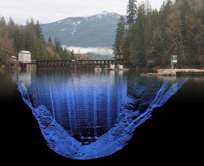
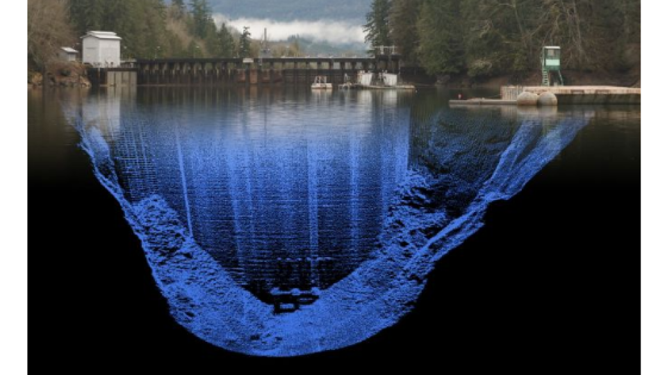
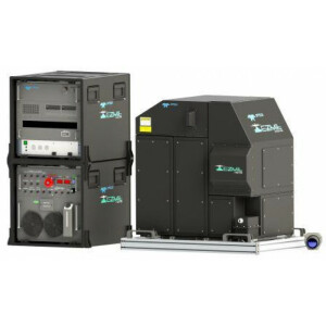
Image 2: Ease of data collection through to final products is enhanced with efficiency-driving AI algorithms and real-time quality control. (Image courtesy: Mike Stecher)
Helping surveyors to get ahead of the game
The surveyor's role is still evolving rapidly, which calls for a different set of skills – not least due to the transition to unmanned aerial vehicles (UAVs or ‘drones’). “For survey businesses to keep up, they must consider how many pilots they need, whether to hire a land surveyor and what the best Lidar investments might be,” comments Hoggarth. “Hiring a land surveyor will increasingly require knowledge of drone-based data collection, and our compact Lidar solutions will be particularly relevant for these customers, who would have conducted conventional land-based surveying in the past.” The theme of integration between land and sea continues to emerge: geospatial teams should be interested in the sea and the land, covering both green and red lasers. “Why would we map a mountain range but neglect the river that comes through it?” asks Hoggarth. “Armed with comprehensive data, we can help our customers deliver a broader range of insights on flood prediction, environmental impacts and other services.”
Key emerging industry trends
Teledyne Geospatial is anticipating the future of AI technologies with its newly-launched Mira AI Marketplace concept. AI can be leveraged to meet new challenges, enabling enterprises to shift from product-centric to data-centric, and introducing possibilities for enterprises to expand their product and service portfolios. This could contribute to business growth and greater client satisfaction due to a wider suite of service offerings and faster project delivery timeframes. “At Teledyne, we recognise the immense expertise within the field and aim to harness this, embedding AI, machine learning and deep learning within a range of our systems and solutions to capitalise particularly on the automatic and data processing benefits offered by AI,” states Hoggarth.
There are ample other solutions that will be critical to solving the ever-more-complex problems faced by geospatial professionals, such as compact Lidar systems lightweight enough to be deployed on a drone. Survey-grade solutions developed for accuracy and quality will be increasingly essential, and integrated solutions that make life easier for surveyors are necessary. Teledyne understands these challenges and has developed workflows that support this, considering key factors, including where the data resides and accounting for asset management. “For example, Teledyne Geospatial provides AI for asset management and tracking via the cloud, bathymetric Lidar, building on the natural synergies between CARIS and Optech,” he continues. “The tools and technologies available to the hydrographic field are indeed transferable into topographic mapping systems, such as the Galaxy range of sensors that provide superior capability for complex terrain like forestry mapping, for example. These are compact, powerful and precise, even identifying tree species and differentiating canopies to understand forest floor/undergrowth.”
What to expect from Teledyne Geospatial in the years to come
Integrated solutions lie at the heart of Teledyne Geospatial. The offering will include turnkey systems, Lidar, sonar, integrated workflows and a range of systems and solutions that support full, precision data collection. Teledyne Geospatial will also work closely with Teledyne Marine concerning sonar systems; both sonar and Lidar can be logged in CARIS’s recently launched Onboard360 acquisition software. “With Onboard360, our near-real-time and autonomous data acquisition and processing solution, it will become possible to create a common workflow using AI and cloud-native technology,” says Hoggarth. “For example, customers can log data to the cloud with their hardware, streamlining their product timeline. A streamlined customer workflow is a central, underpinning goal of Teledyne Geospatial.”
New product developments in the short term
Hoggarth regards software as a key differentiator with customers’ hardware: “We will be releasing new software products in the coming months which will allow users to get the most out of their sensors. One example is the recently launched CZMIL SuperNova, which combines Optech’s powerful bathymetric Lidar with CARIS’s comprehensive processing software.” Terratec AS, a leading Norwegian mapping company, has purchased and flown CZMIL SuperNova for airborne survey projects, collecting and processing marine coastal zone base maps and mapping arctic lakes. Working with the CZMIL SuperNova sensor and AI techniques, they conducted automatic discrimination and noise classification, capitalising on the system’s advanced capabilities and software workflow integration.
The company will be presenting itself under the new Teledyne Geospatial banner and revealing CZMIL SuperNova – as well as discussing other upcoming combined solutions – at key industry events, including Intergeo in September, Ocean Business in October and GEO Business in November.
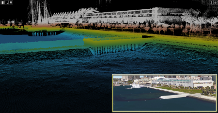
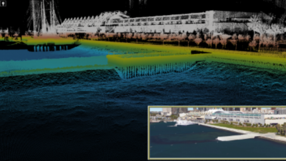
Image 3: Customers benefit from a competitive edge, mapping and delivering data products inside of one workflow. (Image courtesy: Chris Esposito)
About the author - Andy Hoggarth
Andy Hoggarth is vice president of sales and marketing at Teledyne Geospatial.

Do you have questions about this article?
Get in touch with Teledyne Geospatial, and they would be happy to answer any questions you have about pricing, suitability, availability, specs, etc.


