


Forestry Management Using LiDAR
Abstract.
In recent years, Light Detection and Ranging (LiDAR) technology has become widely utilized across various sectors. Forestry management is among these, employing LiDAR to assess tree crown health, create terrain maps, estimate timber volume, and perform numerous other tasks. This article discusses the use of LiDAR for practical forestry, as it is a critical field on which many species of flora and fauna on Earth and humans largely depend.
The sections covered will be Introduction to LiDAR, Forestry Management and its Technology, and How LiDAR can Help Forestry Management. The conclusion will summarize the benefits of using LiDAR in Forestry Management.
Section 1. Introduction to LiDAR
The initial step involves familiarizing oneself with the fundamental principles of LiDAR technology. LiDAR, an acronym for light detection and ranging, operates based on emitting and transmitting a focused beam of light and measuring the duration of time it takes for the light to bounce off an obstacle. When the LiDAR laser beam encounters an object like a tree or a building, some light is reflected to the sensor, as depicted in Figure 1. By precisely timing the return of each laser pulse, the LiDAR system can determine the distance to each reflected point. These computations rely on the time-of-flight (ToF) technique, which assumes a constant speed of light.
The aggregated points form a “point cloud,” a three-dimensional representation of the scanned area of dots within a 3D volume.
Variations among LiDAR models primarily include differences in scanning angle, maximum scanning range, and scanning precision. Most contemporary LiDAR devices offer multiple scanning modes. For instance, the XT32 can adjust rotation speed, scanning angle, and the number of returns, thereby impacting the density of the point cloud and the laser’s ability to penetrate through obstacles like trees and grass.
Integrating LiDAR with an inertial navigation system (INS) results in a system capable of georeferencing each point with centimeter-level precision and accuracy [1]. An example of such an integrated device is the Inertial Labs RESEPI Payload [2]. This compact device is fully customizable to accommodate various applications, offering options such as camera inclusion, LiDAR model selection, and GNSS receiver. It is commonly utilized for drones and other small unmanned aircraft systems (sUAS).
After data collection by LiDAR payloads like the RESEPI Payload, it is crucial to subject the raw data to post-processing before generating the point cloud. For this purpose, Inertial Labs has developed specialized software – PCMasterPro [3]. This software streamlines the post-processing procedure, requiring minimal manual intervention and ensuring seamless integration with hardware and software components.
Section 2. Forestry Management and its Technology
Effective forestry management is crucial for forest conservation and proper utilization. Surveying large areas using handheld devices requires considerable time and personnel, as shown in Figure 2 [4].
Satellite images, which are also used for forest mapping, although they cover large areas, have a low resolution. Such images are of limited use, as they do not allow assessing the condition under tree crowns or aging/ill trees. It also applies to photos from a drone.
Therefore, it shows that efficient forestry management requires modern tools to automate the process as much as possible. The UN Department of Economic and Social Affairs described six global forestry goals in its report [5]. The key is implementing new data-based management methods—accurate and comprehensive inventory.
Why is forestry management critical?
– Forests are the natural environment of more than half of the animal species on the planet. Proper forest management helps ensure these animals have a safe and secure existence [6].
Like other plants, trees participate in photosynthesis and convert carbon dioxide into oxygen, which is necessary for a quality air level. Therefore, it is crucial to maintain a balance to prevent excessive tree-cutting [7].
– Forests provide humanity with many materials used in construction, such as wood, paper, and even medicine. Depletion of forests will lead to a shortage of these materials. [8].
– Tree roots are an excellent skeleton that supports the Earth, thus preventing landslides. They absorb rainwater, preventing the area from flooding[8].
Forests play an essential role in controlling climate change by absorbing carbon dioxide. If managed properly, they can absorb much of the additional CO2 humans emit into the atmosphere [8].
Over the past decades, forestry management has evolved from using hand tools to using LiDAR drones [9, 10].
Section 3. How LiDAR can help in Forestry Management
LiDAR technology has emerged as a powerful tool for forest monitoring, offering numerous advantages over traditional methods. Therefore, Inertial Labs has created a product that will solve many problems related to forest monitoring. Some of these solutions include:
By flying over a forest while using LiDAR, users can get a map of elevations and terrain to properly plan road construction, manage tree cutting/planting, and analyze fire risks [10].
Users can obtain information on forest structure and height. It’s valuable information for analyzing the growth of various breeds of trees, volume, and density crowns , which generally track healthy forests.
It can further development and planning. Ground examinations occupy a lot of time and effort and are very expensive. Aerial scanning allows you to cover a large area and study plant growth and forest expansion. The data can also be used to plan fire and rescue operations or road construction. In addition, lidar data is helpful for statistics, so it is possible to study the development of the forest, even individual tree species.
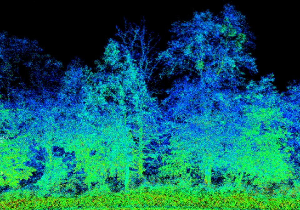
Thanks to the implementation of SLAM technologies in Inertial Labs’ PCMasterPro software, users can scan terrain without the use of a GNSS signal, which will allow them to receive data under the treetops, like that shown in Figure 3 [10]. Data recording does not require a GNSS receiver and base station and can be done either in-flight or on foot.
Thanks to the efforts of engineers from Inertial Labs, the user does not need to have TLS (terrestrial laser scanner) and Aerial LiDAR for full scanning forests because RESEPI combines these two capabilities in one product [11].
LiDAR payloads, such as the RESEPI Payload from Inertial Labs, can be integrated with cameras to obtain highly accurate georeferenced, colorized point clouds. Cameras can also operate at night, and they provide more images for photogrammetry.
Using third-party software (LiDAR360, TerraScan, etc.), users can get georeferenced SLAM data, obtaining comprehensive data from ground and air scans [12, 13]. The high-precision data obtained from RESEPI allows the thickness and height of a tree trunk to be estimated to evaluate timber for harvesting, as shown in Figure 4. There are also features for classification and digital mapping [9]. 

Before using RESEPI Payload, the user must have a drone and flight license, a base station, and a PCMasterPro software license for data processing[14].
Conclusion
Forests are not only a source of timber but also vital ecosystems that play an essential role in maintaining the planet’s ecological balance. Forests cover almost 40% of the Earth’s land area. However, they are constantly affected by various external factors like climate change, illegal deforestation, and fires. Also, the demand for wood and other valuable materials increases due to external factors such as population growth.
Therefore, it is essential to organize forest management as efficiently as possible, which is where the collection and processing of LiDAR data can help. In contrast to manual methods and photogrammetry, LiDAR data collection is much faster, and the user receives a three-dimensional point cloud rather than two-dimensional, low-information photographic images. Thanks to this, a wide range of tasks can be solved:
Tracking the condition of tree crowns
Calculating the volume of wood
Building digital maps (digital surface models, digital elevation models)
This information will help in planning the cutting/planting of forests, road construction, and monitoring the condition of trees.
Inertial Labs is committed to providing high-quality solutions with customization and excellent value for money at an affordable price.
References
[1] Wikipedia Contributors. “Inertial Navigation System.” Wikipedia, Wikimedia Foundation, 21 May 2019, en.wikipedia.org/wiki/Inertial_navigation_system.
[2] “RESEPI – LiDAR Payload & SLAM Solutions.” RESEPI, lidarpayload.com. Accessed 3 June 2024.
[3] Inertial Labs. “RESEPI Quick-Start Guide – Setting up Your LiDAR Survey System and PCMaster – Inertial Labs.” YouTube, 4 Aug. 2022, youtu.be/AygQTBVNrKw. Accessed 3 June 2024.
[4] Drones, Airborne. “FOREST MANAGEMENT with Drones.” Nextech, 13 May 2021, nextech.online/forest-management/. Accessed 3 June 2024.
[5] “United Nations Forum on Forests» Global Forests Goal Report 2021.” Www.un.org, www.un.org/esa/forests/outreach/global-forests-goal-report-2021/index.html.
[6] Wikipedia Contributors. “Forest Management.” Wikipedia, Wikimedia Foundation, 14 Oct. 2019, en.wikipedia.org/wiki/Forest_management.
[7] Huff, Tristan, and S. (Steven Clay) Bowers. “Tools for Measuring Your Forest [2014].” Ir.library.oregonstate.edu, ir.library.oregonstate.edu/concern/administrative_report_or_publications/wh246s32r. Accessed 3 June 2024.
[8] How Drone Technology Is Becoming Essential for Forestry – Equinoxsdrones. 10 Apr. 2024, equinoxsdrones.com/how-drone-technology-is-becoming-essential-for-forestry/.
[9] Wikipedia Contributors. “Digital Elevation Model.” Wikipedia, Wikimedia Foundation, 16 Mar. 2019, en.wikipedia.org/wiki/Digital_elevation_model.
[10] Wikipedia Contributors. “Simultaneous Localization and Mapping.” Wikipedia, Wikimedia Foundation, 8 July 2019, en.wikipedia.org/wiki/Simultaneous_localization_and_mapping.
[11] “RESEPI – LiDAR Payload & SLAM Solutions.” RESEPI, lidarpayload.com. Accessed 3 June 2024.
[12] “LiDAR360 Software and Real-Time Point Cloud Display.” Www.greenvalleyintl.com, www.greenvalleyintl.com/LiDAR360/.
[13] “Terrasolid – Software for Point Cloud and Image Processing.” Terrasolid, 21 Sept. 2023, terrasolid.com/.
[14] “Buy Reach RS2+ | Buy Multi-Band RTK GNSS Receiver.” Emlid Store US, store.emlid.com/products/reach-rs2-plus?variant=47253689467185. Accessed 3 June 2024
Do you have questions about this article?
Get in touch with Inertial Labs, Inc., and they would be happy to answer any questions you have about pricing, suitability, availability, specs, etc.

More articles


