
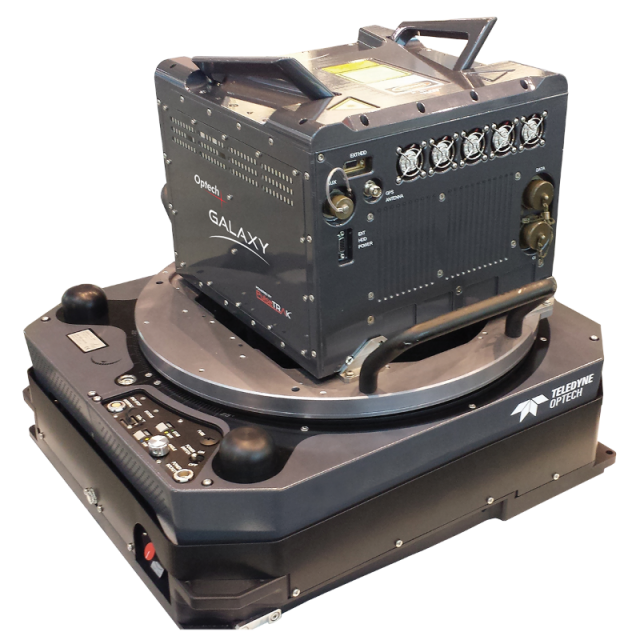
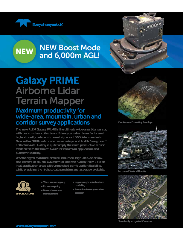
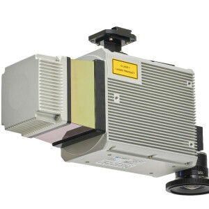
ALTM Galaxy PRIME
Compact, high-performance lidar sensor provides industry-leading collection efficiency and point density in all terrains
The new Galaxy PRIME is the next evolution of the popular Galaxy wide-area/corridor Lidar mapping platform that includes the advanced and unique PulseTRAK and SwathTRAK productivity feature sets. An innovative “boost mode” increases range performance, and an expanded range of motion for the dynamic FOV used by SwathTRAK ensures that the Galaxy PRIME is quite simply the most versatile, highest-performing, and most productive sensor on the market.
Teledyne Geospatial
Vaughan, CA
Description
The new Galaxy PRIME is the next evolution of the popular Galaxy wide-area/corridor lidar mapping platform that incudes the advanced and unique PulseTRAK™ and SwathTRAK™ productivity feature sets. An innovative “boost mode” increases range performance, and an expanded range of motion for the dynamic FOV used by SwathTRAK™ ensures that the Galaxy PRIME is quite simply the most versatile, highest-performing, and most productive sensor on the market, no matter the type of terrain you survey. Coupled with its compact form factor, the Galaxy PRIME offers maximum application and platform flexibility.
Core to Galaxy PRIME is a significant increase in collection efficiency — as much as 50% over competing fixed FOV sensors —when using Galaxy PRIME's SwathTRAK technology. SwathTRAK dynamically adjusts the Galaxy’s scan FOV in real time during data acquisition, enabling fixed-width data swaths and constant point density, even in highly variable terrain — effectively enabling you to survey steep mountains as if they were flat! The result is far fewer flightlines to collect and process, and a consistent point distribution whether on hill peaks or valley bottoms — in fact, the steeper the terrain, the greater the project cost savings.
Do you have questions about this product?
- Questions about price, availability, and/or retailers
- Questions about technical specifications and usage
- Questions about suitability for your project or application
Specifications
-
General
-
Year of introduction
2015
Year of last update
2020
Total Weight [kg]
35
Power requirements
28V; 300W
Type of GNSS/INS positioning system
Applanix AP60
Camera
PhaseOne iXM-RS150
Data storage facilities
Internal SSD (1 TB); removable external SSD (1 TB)
Mission planning software
FMS-MIssion Manager
Postprocessing software
Lidar Mappng SUite
-
Application
-
Main applications
high-density mountain surveying; floodplain mapping; corridor; urban
-
Measurement Characteristics
-
Scan frequency [Hz]
120
Min. pulse frequency [Hz]
50,000
Max. pulse frequency [Hz]
1,000,000
Max. field of view [deg]
60
Max. number of recorded echoes per pulse
8
Full-wave form digitization
Y
Pulse sampling frequency [GHz]
1
multiple pulses in air
Y
Recording of intensity of return signal [bits]
12
-
Operation Characteristics
-
Platform
Helicopter, Fixed-wing, Gyroplane
Min. flying height [m]
240
Max. flying height [m]
6000
-
Laser Pulse Characteristics
-
Wavelength [nm]
1064
Standard pulse length [ns]
3.5
Beam divergence [mrad]
0.25
Type/class laser
IV
Eyesafe range [m]
240m (low power; 1000 kHz)
-
More information
-
Distinguishable features
SwathTRAK (dynamic FOV); built-in roll compensation; industry-leading measurement precision; discrete (8 returns) and full wavefrom capability (unlimited returns); PulseTRAK (full coverage across MTA/MPiA blindzones, without data interpolation)
-
Uncertainty and resolution
-
Pitch and roll pointing precision [deg]
0.005
Heading pointing precision [deg]
0.008
Elevation precision at 1 km [m]
0.03
Planimetric precision at 1km [cm]
10
-
Application areas
-
Select an application area:
Documents
Brochure
galaxy-prime-brochure.pdf
594.14 KB
Videos


