


Synchronisation of drone-based and mobile Lidar mapping to advance urban digital twins
Accurate and up-to-date geometric data of a city is widely used in urban planning and development in different parts of the world. The applications of such data vary from the reconstruction and modernization of ancient cities in Europe and Latin America to the new design & construction of megacities in Asia and the Middle East. Accurate geometry is also crucial for smart cities, which integrate many sensors to automate many processes, from self-driving car navigation to traffic flow optimisation and automated delivery systems using drones.
Lidar technologies for digital twins
Given the considerable footprint of cities, using automated airborne and ground-based laser scanning systems can help address the challenges of building highly accurate three-dimensional models of urban areas. This requires collecting and constantly updating a database of three-dimensional digital twins of buildings, structures and road infrastructure over a wide area of urban agglomerations. At the same time, possible restrictions on using drones in city areas have increased the demand for ground scanning systems, and the high volume of laser scanning is driving vehicle-mounted Lidar technology.
Maxim Baklykov, TOPODRONE CEO, notes that more and more TOPODRONE users worldwide use Lidar equipment for urban mapping. The application trend goes along with TOPODRONE R&D team’s continuous efforts to improve Lidar systems, making them more affordable and accessible with the ability to mount on any drone, vehicle or backpack.
Creating a digital twin of Malaga (Spain) with drone-based and mobile lidar
Atyges, a leading aerial photography and laser scanning company in Spain carried out an aerial and terrestrial laser scanning project in Malaga. The surveys were carried out in the urban area, which was forested and with mountain relief. Using the drone-based Lidar allowed the team to obtain high-precision relief, and high-resolution photos provided all the information necessary to map the surroundings. Mobile laser scanning was performed, capturing roads and surrounding infrastructure and adding value to build up a digital twin of the city.
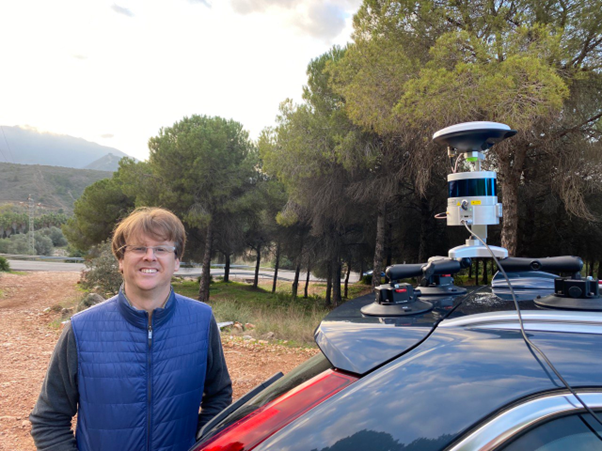
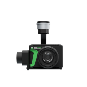
Image.1 TOPODRONE LIDAR HI-RES installed on the car for terrestrial LIDAR mapping
Lidar datasets were captured by TOPODRONE LiDAR HI-RES and high-resolution images by a professional high-resolution TOPODRONE P61 camera installed onboard of DJI M300 drone; after finishing the flights, the same TOPODRONE Lidar HI-RES was installed on a vehicle for mobile scanning.
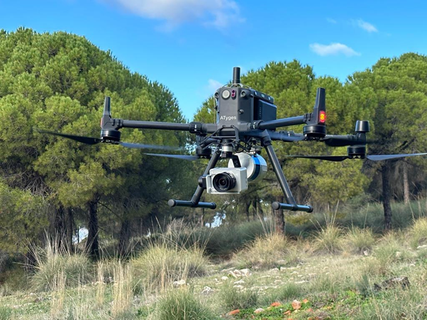
Image. 2 Drone based photogrammetry and Lidar survey with TOPDORONE P61 and LIDAR HI-RES
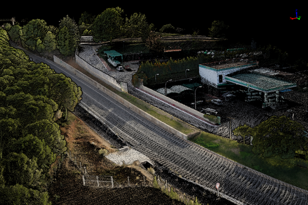
Image.3 Synchronisation of drone and terrestrial Lidar point cloud
TOPODRONE surveying equipment allows simultaneous acquisition of high precision Lidar point cloud and outstanding aerial imagery by full-frame 61 Mpixel sensor, produced by SONY, that significantly reduces the duration of fieldwork and it provides all necessary information for creating maps & CAD layers.
According to Federico Alva, CEO of ATyges, “the project has proved the advantage of TOPODRONE approach to develop equipment, which can be installed on different carriers (drone, VTOL, vehicle, backpack) and allows surveyors to perform a variety of tasks, saving time and money invested the equipment. Drone and mobile laser scanning datasets were automatically processed in TOPODRONE Post Processing software and required no additional actions to couple them together”.
Using photogrammetry and Lidar to create a digital twin of Peachtree City, USA
Jack W. Berry & Associates, a full-service Aerial Surveying and Mapping firm utilizing the latest Lidar and digital imagery technology in Georgia and Southeast of United States, tested the synchronization of drone-based Lidar, photogrammetry and terrestrial laser scanning survey approach. They performed a mapping project in Peachtree City, Georgia.
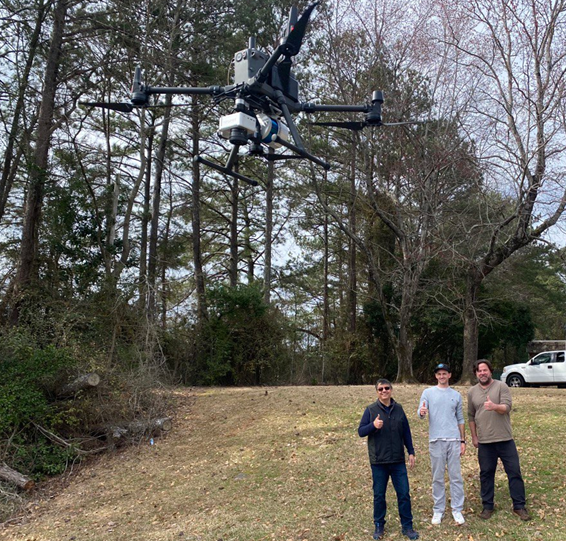
Image. 4 Photogrammetry and Lidar survey by Jack W. Berry & Associates
LiDAR datasets were captured by TOPODRONE LiDAR HI-RES while photogrammetry data was collected with TOPODRONE P61 camera. Both devices were simultaneously installed onboard of DJI M300 drone; after finishing the flights, the same TOPODRONE LIDAR HI-RES was installed on a vehicle to perform mobile laser scanning of the road and surrounding infrastructure.
Several ground control points were measured in the field to evaluate the quality of the data, and the automatically generated accuracy report showed 1-2 cm x,y,z accuracy of captured LIDAR datasets.
" For large area aerial photography & LIDAR survey Berry and Associates uses Optech Galaxy T100 LIDAR system and Phase One 150 Mp aerial camera on board of Twin Commander aeroplane”, Salah Ezzaoudi, CEO of Jack W. Berry & Associates, explains. “The TOPODRONE equipment has allowed us to expand our business into small-area surveying and mobile laser scanning, where it is impossible to get an aircraft into the air”.
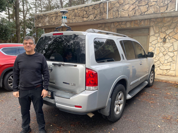
Image. 5 Capturing terrestrial Lidar data by TOPODRONE HI-RES
Importantly, the synchronisation of UAV and vehicle-based Lidar surveying approaches makes it possible to obtain highly accurate 3D models from the air and ground. Missing information on the characteristics of roofs and other objects not visible from the ground can be captured from the air using Lidar and a photogrammetric camera mounted on a drone.
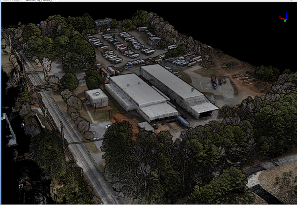
Image. 6 Synchronisation of drone and terrestrial LIDAR data allows to get the most detailed 3D models of buildings from different points of view
About TOPODRONE
TOPODRONE designs and manufactures affordable Lidar & UAV solutions for high-precision survey and mapping. They offer ready-to-fly and easy-to-use drones with an additionally installed GNSS receiver connected with a modified and calibrated camera, everything you need to get high accuracy data up to 3 cm XYZ accuracy without using ground control points (GCP).
Do you have questions about this case study?
Get in touch with TOPODRONE, and they would be happy to answer any questions you have about pricing, suitability, availability, specs, etc.


![Do-Giant-Tortoises-Make-Good-Neighbors-1[1].jpg](https://cdn.geo-matching.com/vRMO2Edp.jpg?w=320&s=a6108b2726133ff723670b57bc54c812)


