
Initial Observations of the Galileo High Accuracy Service
The news that the Galileo High-Accuracy Service (HAS) has successfully entered the next phase of its implementation has many people in the GNSS industry excited.
Read the full article here
What is Galileo HAS?
Galileo HAS is a revolutionary new high-accuracy Precise Point Positioning (PPP) correction service available around the globe, with enhanced performance in Europe. Galileo HAS is a dual-constellation, multi-frequency correction service, with support for the following Galileo and GPS signals:
- Galileo: E1, E5A, E5B, E6B
- GPS: L1, L2C, L5
The corrections are free of charge and delivered via signal in space (SiS), directly from the Galileo satellites themselves on the E6B frequency. Corrections will also be available terrestrially and streamed over the internet using Networked Transport of RTCM via Internet (NTRIP) Protocol. Corrections are broadcast for both Galileo and GPS constellations resulting in real-time <20 cm horizontal accuracy (with 95% confidence) after some convergence time.
Galileo HAS Roadmap
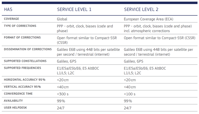
Galileo HAS is being implemented in three phases over several years. Phase 0 began in 2019 and consisted of internal testing and validation. In January 2023, Galileo HAS entered Phase 1, or “initial service,” of its implementation. During Phase 1, which we are currently in, Galileo HAS provides global coverage, in what its operators are calling “service level 1.” There are two service levels proposed for the final phase of the implementation roadmap. Service level 1 (SL1) will eventually provide 20 cm accuracy across the globe with convergence times of less than five minutes. Service level 2 (SL2) will be available only in Europe and will also provide 20-cm accuracy. However, within the SL2 territory, convergence times will be reduced to less than two minutes, whereas elsewhere convergence time will remain at the five-minute-or-better threshold.
SL2 will be available for Europe during Phase 2, which will be known as “full service” and is estimated to go live in early 2024.
Currently, Phase 1 initial service has a reduction in performance targets and is operating in SL1 across the globe. SL1 provides corrections for satellite orbits/clocks and not yet for code/phase biases. Because of this, current convergence times for SL1 are around 25 to 60 minutes worldwide.
Next year during Phase 2, or “full service,” SL1 will offer a worldwide improved convergence times of <300 seconds (under five minutes). At the same time, SL2 will be available in Europe to still deliver <20 cm accuracy but with improved convergence times of <100 seconds (under two minutes). This will be achieved by incorporating better corrections using atmospheric correction models.
The current Galileo HAS service area is defined as the geographical area in which Galileo HAS users can expect the fulfilment of the minimum performance levels (MPLs) specified in the Galileo HAS service definition document (SDD) from the European Union.
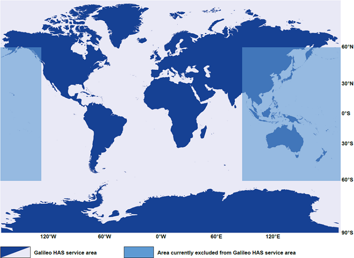
Image Source: “Galileo HAS Service Definition Document, Issue 1.0, January 2023” © European GNSS Agency, 2020
You can see the Galileo HAS service area map in the above figure. Note that Australia and its surrounding region are currently excluded from the Galileo HAS service area.
Note that the service area is global excluding the following areas identified in the figure above:
- Rectangle defined by Latitudes [60ºS – 60ºN] and Longitudes [90ºE – 180ºE]
- Rectangle defined by Latitudes [60ºS – 60ºN] and Longitudes [125ºW – 180ºW]
This does not prevent users from receiving and applying Galileo HAS corrections in that region if they happen to be able to receive them from the Galileo constellation. However, there is no guarantee that the MPLs will be met, and therefore different performance might be observed.
How does Galileo HAS work?
Galileo HAS is a Precise Point Positioning (PPP) service that calculates satellite orbit and clock corrections from a global network of ground reference stations and broadcasts these corrections to users. In typical PPP systems, such as Atlas®, ground stations uplink their corrections to geostationary satellite(s) where they are then broadcast via signal in space (SiS).
The difference between Galileo HAS and a typical PPP service is that correction data generated by the Galileo ground reference stations is being disseminated from each Galileo satellite instead of only one to three satellites, as with conventional PPP systems and even SBAS.
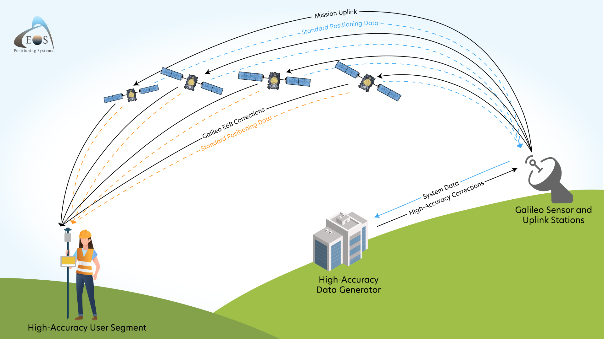
Graphic created by Eos Positioning Systems based on information from “Galileo High Accuracy Service (HAS) Info Note”
For the corrections to be useful, end-users must have a compatible GNSS receiver with not only multi-constellation and multi-frequency support (including the required E6 frequency), but which is also capable of decoding the Galileo HAS correction message formats. Specifically, the receiver must track GPS frequencies L1/L2/L5 and Galileo frequencies E1/E5/E6.
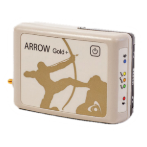
Eos Positioning Systems® released the Arrow Gold+™ GNSS receiver in 2021 in anticipation of Galileo HAS. The Arrow Gold+ represents another first in the mapping and GIS market. With a single receiver and no paid subscription to a differential correction source, a user can achieve sub-20 cm horizontal and sub-40 cm vertical accuracy.
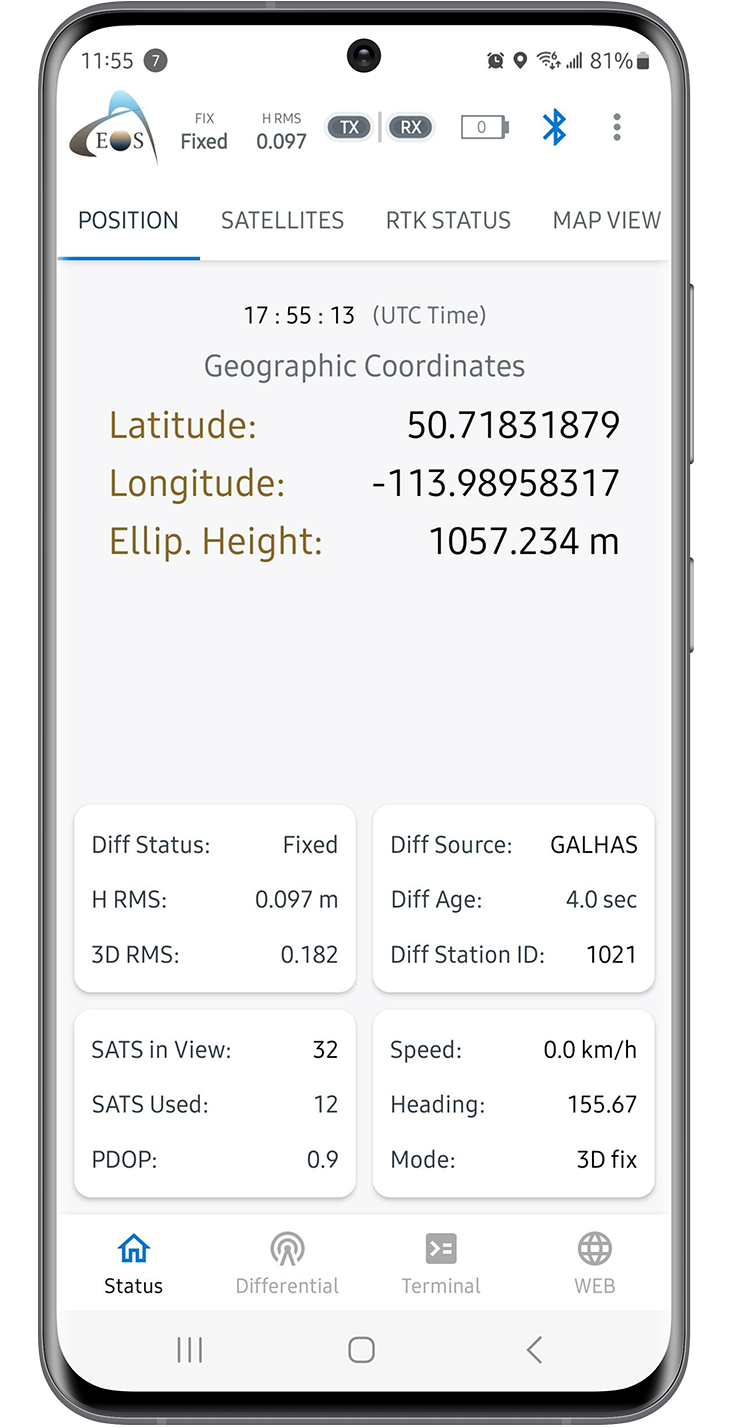
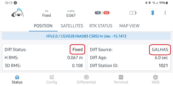
The above screenshot displays the “Position” tab of Eos Tools Pro. From this tab, users can monitor their differential correction source, the number of satellites being used, and more.
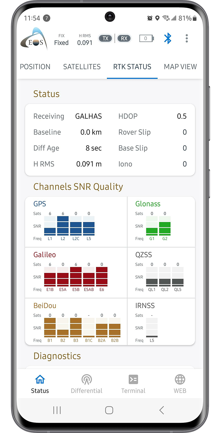
The above screenshot displays the “RTK Status” tab of Eos Tools Pro. From this tab, users can view the status of their differential correction source, in this case, Galileo HAS.
Typical Performance of the Arrow Gold+ Using Galileo HAS Initial Service
Since Galileo HAS is currently in its Phase 1 initial service of implementation, we should expect reduced performance, particularly in convergence times.
In recent beta tests, Eos partners and staff observed two performance metrics, convergence times and absolute accuracy, when using an Arrow Gold+ GNSS receiver connected to Galileo HAS for corrections. The Arrow Gold+ was set up over a highly accurate control point. The control point coordinates were calculated using a PPP service available from the Canadian Geodetic Survey division of Natural Resources Canada.
PPP is an advanced technique used to post-process GNSS data. The PPP service uses precise satellite orbit, clock and bias corrections derived from a global network of GNSS receivers to calculate highly accuracy positions anywhere on the globe. The control point coordinates derived from PPP were processed six days after data collection to ensure that precise orbits were being used in the comparison. The resulting error estimates for our control point coordinates were 5 mm, 4 mm, and 15 mm for latitude, longitude, and height (respectively).
Each test logged several one-hour sessions of GNSS data including the Galileo HAS corrections. These HAS corrected positions were compared to our highly accurate PPP control point coordinates. The charts below show the horizontal error decreasing during the Galileo HAS convergence tests. In most tests, the HAS corrected positions were within 10 cm of our control point after one hour of logging.
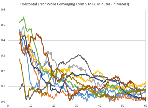
The above chart shows the horizontal error decreasing during our Galileo HAS convergence tests. In the majority of our tests, the Galileo HAS corrected positions fell within 10 cm of the set control point.
The diagram below shows positions corrected by Galileo HAS that were collected over time (positions were collected at a one-second interval). The Arrow Gold+ receives and processes the Galileo HAS corrections received over the E6B signal from the Galileo satellites. As shown below, after approximately 60 minutes, the best accuracy achieved is <20 centimeters, and when a fixed solution is achieved, the Arrow Gold+ can get down to even the sub-decimeter level. This is within the stated accuracy that we should expect from the service, which is <20 cm in nominal conditions.
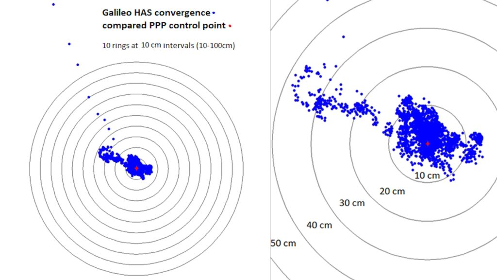
The above scatterplot shows positions corrected by Galileo HAS that were collected at a one-second interval. After approximately 60 minutes, the best accuracy we achieved was under 20 centimeters. When a fixed solution is achieved, the Arrow Gold+ was able to achieve sub-decimeter level accuracy.
We will have to wait until HAS enters Phase 2 (full service) before we will see the convergence times reduced to <300 seconds (about 5 minutes) globally and <100 seconds (about one and a half minutes) in Europe.
Source: “Galileo High Accuracy Service (HAS) Info Note” © European GNSS Agency, 2020
Datum Considerations
The Galileo HAS system uses a specific reference frame called the Galileo Terrestrial Reference Frame (GTRF). The GTRF is an independent realization of the International Terrestrial Reference System (ITRS) and is based on the estimated coordinates of each one of the Galileo sensor stations. For a given point, the difference between coordinates expressed in ITRF and GTRF is less than 3 cm.
The interoperability between GPS and Galileo should be considered since the GPS and Galileo reference frames are close versions of ITRF. This provides a high level of interoperability between the positions collected with GPS and those collected with Galileo.
By using an Arrow Gold+ GNSS receiver with a fixed Galileo HAS signal, anyone within the available service area can achieve <20 cm accuracy.
Now that Galileo HAS has entered its initial phase of implementation, the mapping and GIS community can benefit today. By using an Arrow Gold+ GNSS receiver, anyone within the initial service area can achieve <20 cm accuracy.
Are you interested in getting started? Contact our team today to inquire about using Galileo HAS with the Arrow Gold+.
Do you have questions about this case study?
Get in touch with Eos Positioning Systems, and they would be happy to answer any questions you have about pricing, suitability, availability, specs, etc.


![Do-Giant-Tortoises-Make-Good-Neighbors-1[1].jpg](https://cdn.geo-matching.com/vRMO2Edp.jpg?w=320&s=a6108b2726133ff723670b57bc54c812)


