Hydrodron, the First Autonomous Hydrographic Unmanned Vessel in Poland Integrated With SBG INS/GNSS
Marine Technology presented HydroDron, the first autonomous hydrographic unmanned vessel in Poland, at Baltexpo 2019. The recently finished project was co-financed by the National Centre for Research and Development and was awarded in the competition “Baltexpo Golden Anchor 2019”.
HydroDron Allows Surveying in Inaccessible Waters
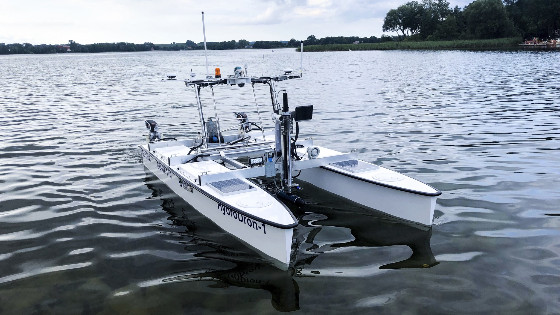
HydroDron is an unmanned catamaran made of lightweight and durable material, with a double-hull system (4m long and 2m wide). The engine part, equipped with two electric motors working independently of each other, provides adequate speed and manoeuvrability, reaching a maximum speed of over 10 knots.
This autonomous and remote-controlled floating platform dedicated to hydrographic measurements in limited waters is characterized by mobility. It is possible to carry it in the mission area on a car trailer or a larger surface vessel and launch it from the trailer from the beach, shore, wharf, platform, or surface vessel. HydroDron can operate in waters that are inaccessible or difficult to reach for larger manned units, whose use may result in impossible or unprofitable.
A USV Fully Equipped for Hydrography
The development of the platform’s autonomous navigation and automatic 3D hydrography systems represents a significant improvement of Marine Technology’s remotely controlled multi-purpose surface platform for operation in port areas and other restricted areas. The platform will now be able to perform bathymetric, sonar, and other measurement missions in a fully autonomous mode, implementing adaptive trajectory planning and automatic 3D analysis of near real-time situation measurement data around the platform.

Photo Credit: Marine Technology
HydroDron Equipment
HydroDron integrates a wide range of measuring equipment in order to provide a multitude of different variants:
- Integrated bathymetric and sonar system 3DSS-DX-450 from Ping DSP
- Industrial computer for data acquisition Getac S410 (the main element of the hydrographic station)
- External Dual Antenna Inertial Navigation System Ekinox2-D from SBG Systems
- Single-beam dual-frequency sonar HydroBox HD from Syqwest
- High-frequency Singlebeam sonar Echologger EU400
- LiDAR PUCK VLP-16 by Velodyne
A sensor system also monitors the situation on and around the platform to increase situational awareness, including two vertical probes, one in each hull, two video cameras (rotating and stationary), and a weather station. In addition to typical navigation data, video data from both cameras, weather information, battery voltage level, current depths under each float, etc. are recorded. Radar and two laser rangefinders (bow and stern) are used in the unit’s anti-collision system. Navigation data is transmitted to the shore station, consisting of two consoles: a dedicated navigation console, and a hydrographic one with the Getac computer.
The hydrographic measurements are ensured, from the planning of measurement works to the development of the final product, by the Hypack software. Hydrographic data from the Multibeam probe and LiDAR are recorded on board industrial computers.

Photo Credit: Marine Technology
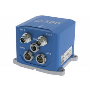
The Ekinox-D Inertial Navigation System
The very compact Ekinox2-D Dual Antenna Inertial Navigation System from SBG Systems contains a Survey-grade IMU with a Dual antenna RTK GNSS receiver. This advanced INS/GNSS provides orientation, heave, and position accuracy to the centimetre. Its small size, low weight, and low-power but robust enclosure (IP 68) make it ideal for applications where space is critical, such as USVs.
Ekinox sensors embed an 8 GB data logger for post-operation analysis or post-processing. It also comes with an extremely easy-to-use web interface. Data from this inertial sensor can also be post-processed with SBG’s in-house PPK software: Qinertia. Qinertia post-processing software enhances SBG INS performance by post-processing inertial data with raw GNSS observables. The software gives access to offline RTK corrections from more than 7,000 base stations located in 164 countries – and is always up-to-date.
Do you have questions about this case study?
Get in touch with SBG Systems, and they would be happy to answer any questions you have about pricing, suitability, availability, specs, etc.
Related products


![Do-Giant-Tortoises-Make-Good-Neighbors-1[1].jpg](https://cdn.geo-matching.com/vRMO2Edp.jpg?w=320&s=a6108b2726133ff723670b57bc54c812)


