


Creation of a 3D Point Cloud with the GNSS X5 Mobile and a Cell Phone
The integration of photogrammetry and precision GNSS positioning has transformed the way we generate three-dimensional models of our environment. In this article, we will explore in detail the step-by-step process of conducting a geotagged photo capture session using a METTATEC model X5 MOBILE high-precision mini GNSS receiver with NTRIP corrections, in combination with a smartphone equipped with a camera with a high-resolution digital sensor. This process will enable the creation of an extremely accurate and detailed 3D point cloud, suitable for a variety of applications ranging from mapping to architecture.
Necessary equipment
1 - X5 Mobile GNSS Receiver in High Precision Rover mode with RTK-NTRIP Corrections:
A high-precision GNSS receiver that can receive RTK-NTRIP corrections to achieve centimeter accuracy in location. Location data will be added to the EXIF metadata of images captured in JPG format.
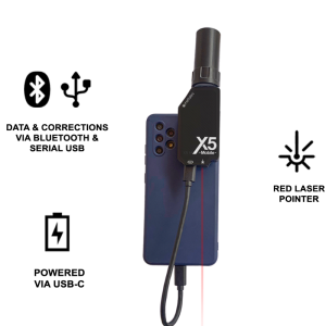
The GNSS X5 MOBILE connects to the cell phone or to a power bank to be energized. Positioning data is sent to the app via Bluetooth or the USB serial port. The X5 MOBILE requires and can work with any Photogrammetry or GIS application that uses NMEA data (Example: PIX4Dcatch).
The X5 MOBILE can work in two modes: Single (up to 16 cm H and V precision) and RTK-NTRIP (up to 1 cm H and V precision).

2 - Smartphone with a High Resolution Digital Camera:
An Android smartphone (version 9 or higher) with a high-resolution camera. This is essential to capture sharp, detailed images. Currently, all smartphones feature cameras with good resolution and photographic capabilities. Internet connection on the cell phone is required if the X5 MOBILE will be used in RTK-NTRIP mode.

3 - NTRIP CORS Service:
Access to a CASTER for RTK-NTRIP correction service. The NTRIP correction service is provided through a system of continuous reference stations (CORS), managed by a specialized server that collects, processes and sends correction data to multiple users who are online.

4 - Batteries and Storage
Ensures that the smartphone has enough power and storage space for the duration of the session. The most comfortable way to carry out the image capture session is by energizing the GNSS by connecting the X5 MOBILE to the cell phone, using the USB-C cable of the equipment. Additionally, the GNSS can be connected to a Powerbank.
5 - GNSS App and Software for Photogrammetry:
Use specialized applications or software -such as Pix4DCatch- to capture images and automatically receive positioning data from the GNSS receiver, and then preview.
Step by step process
1 - Planning
Select the location and the capture area, considering good light and access conditions.
Define the specific objectives for the creation of the point cloud and the 3D models that you want to generate.
2 - Equipment Configuration
Place the Rover X5 MOBILE mini GNSS receiver near or on the vertical axis of the phone’s camera lens in a fixed location on the housing.
Make sure the X5 MOBILE is receiving NTRIP fixes: This is accomplished through the following steps:
Power the X5 MOBILE to the cell phone using the USB cable.
Using a GNSS application, such as the free “Bluetooth GNSS” App, select the X5MOBILE as the main GNSS to receive positioning data in RTK-NTRIP mode, to do so, enter the connection data to the CORS service in the NTRIP connection form.

3 - Capture of photographs and GNSS data
Start the capture App: for example, the Pix4Dcatch.
Begins capturing images in a planned sequence. Make sure you capture enough overlapping photos for better alignment in the photogrammetry process.
Centimeter positioning data will be saved in the EXIF data of the captured images.

4 - Data Download
After the session is complete, download the images to a computer for further processing or upload the images to a cloud processing service.
5 - Photogrammetric Data Processing
Use a GNSS software (Pix4D) or a cloud service (such as DroneDeploy or Pix4DCloud) to process the collected images. Select the appropriate geodetic reference system if applicable.
Process the images and generate the 3D point cloud. Make sure that the software can use the GNSS coordinates to georeference the images.

6 - 3D Point Cloud Generation
The photogrammetry software will align the images and calculate the three-dimensional position of the feature points in the photos.
Upon completion, you will get a complete and accurate 3D point cloud representing the capture area.

7 - Refinement and Analysis
Refine the point cloud by removing noisy or outlier points if necessary.
Use analysis tools to measure distances, angles, and volumes in the 3D point cloud.

8 - Applications and Export
The generated 3D point cloud can be used in 3D modeling software, GIS systems, architectural design software, and more.
Export the point cloud in formats (like .LAS) compatible with the applications you plan to use.
Conclusion
The integration of high-precision GNSS technology with modern smartphone capabilities opens up new frontiers in the field of photogrammetry. Utilizing the METTATEC X5 MOBILE Rover GNSS mini-receiver, equipped with RTK-NTRIP corrections, in conjunction with a high-resolution camera on a smartphone, provides a streamlined and highly accurate method for creating 3D point clouds. This approach not only democratizes the technology by making it more accessible but also offers centimeter-level accuracy that is crucial for various professional applications. Whether you are involved in mapping, architecture, or any discipline requiring precise spatial data, this combination of technologies offers a robust solution. By following the step-by-step guide outlined in this article, you can achieve reliable and versatile 3D point clouds that can be utilized across a multitude of platforms and applications.
Do you have questions about this case study?
Get in touch with METTATEC, and they would be happy to answer any questions you have about pricing, suitability, availability, specs, etc.
Related articles


![Do-Giant-Tortoises-Make-Good-Neighbors-1[1].jpg](https://cdn.geo-matching.com/vRMO2Edp.jpg?w=320&s=a6108b2726133ff723670b57bc54c812)


