VMZ
The new, fully integrated, accurate, and compact RIEGL VMZ Hybrid Mobile Laser Mapping System enables combined static and kinematic data acquisition using a single RIEGL VZ-400(i), VZ-1000 or VZ-2000 laser scanner – resulting in lower mobilization costs and a high return on investment. Flexible setup, easy mounting, and a user-friendly workflow mobilize your RIEGL 3D Terrestrial Laser Scanner for applications like mapping of transportation infrastructure.

RIEGL | Innovation in 3D
Horn, AT
Description
The new, fully integrated, accurate, and compact RIEGL VMZ Hybrid Mobile Laser Mapping System enables combined static and kinematic data acquisition using a single RIEGL VZ-400(i), VZ-1000 or VZ-2000 laser scanner – resulting in lower mobilization costs and a high return on investment. Flexible setup, easy mounting, and a user-friendly workflow mobilize your RIEGL 3D Terrestrial Laser Scanner for applications like mapping of transportation infrastructure, city modelling, mine surveying, bulk measurements, etc.
Do you have questions about this product?
- Questions about price, availability, and/or retailers
- Questions about technical specifications and usage
- Questions about suitability for your project or application
Specifications
-
General
-
Year of initial introduction
2014
Year of last update
2017
Application
Outdoor
-
Positioning
-
GNSS receiver: Brand and model
Trimble Applanix
IMU: Brand and model
Trimble AP20
Wheel sensor: Brand and model
Applanix DMI (Rotary Encoder)
Number of wheel sensors
1
-
Lidar Sensor
-
Brand
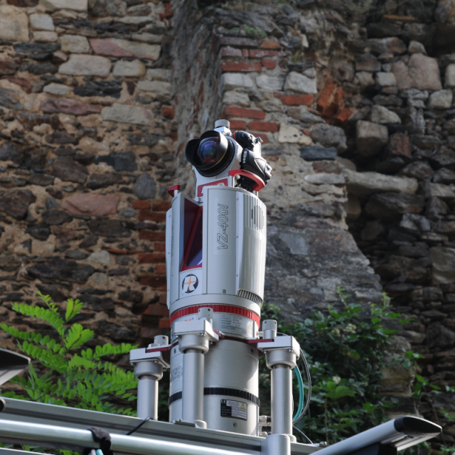
RIEGL VZ-400i
Number of laser scanners
1
Laser safety classification
1
Min. Range [m]
0.5
Max Range [m]
800
Beam divergence [mrad]
0.35
Intensity recording [bit]
16
Max. vertical field of view [deg]
100
Max. measurement rate [kHz]
1200
Scans per second
240
-
Operation
-
Built-in Stabilisation
Y
Main applications
Efficient Data and Image AcquisitionGIS Mapping and Asset ManagementCity ModelingSurveying in Open-Pit MiningMeasurement of Bulk MaterialsRoad Surface ScansShore Surveying and Marine ApplicationsCivil EngineeringTopographyMonitoringFacade ModelingAs-Built SurveyingArchitectureArchaeology
Distinguishing features
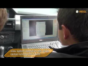
IMU/GNSS unit, fully integrated to support RIEGL VZ-400(i),VZ-1000 and VZ-2000 scanners for mobile (kinematic) data acquisitionEasy coupling and de-coupling of the VZ scanner from IMU/GNSS unitQuick switch from mobile to terrestrial applications, and vice versa,without losing stability of system calibrationFlexible installation options - vertical and horizontal setupFrame based roof-mount compatible with standard roof barsImage data acquisition with a calibrated and GPS synchronized NIKON® DSLR cameraAdditionally panoramic camera systems such as POINT GREY Ladybug® are availableSingle power supply for VZ scanner and IMU GNSS unit from a standard car batteryEasy system operation with single laptop running RiACQUIRE (additional camera may need an additional laptop)
Training provided
Y
-
Camera System
-
Brand and model
Nikon DSLR
Number of cameras
1
Spectral Bands [PAN, RGB, NIR, CIR]
RGB
-
Dimensions & Environment
-
Weight [kg]
24.1
Min. Operation temp. [°C]
-20
Max. Operation temp. [°C]
40
Max. humidity [%]
80
-
Included Processing Software
-
Photogrammetry Software
No
Laser Point Clouds Software
Yes, RIEGl Software
-
Control Unit
-
Computer
Standard Laptop with RIEGL RiACQUIRE
WiFi
N
Documents
Brochure
brochure_VMZ
Other documents
-
VMZ Brochure5.47 MB
-
RIEGL VZ-2000i Datasheet.pdf4.32 MB
-
RIEGL VZ-400i Datasheet.pdf4.61 MB
Videos


