
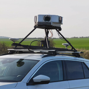
Mosaic Meridian Mobile Mapping System with High-Resolution 360° Camera and LiDAR
Unmatched 360° Imagery and LiDAR Precision for Surveying, Mapping, and GIS.
The groundbreaking solution is designed to meet the needs of surveying, mapping, and GIS professionals who demand high-quality imagery and reliable LiDAR data—all within a budget-friendly package.
Mosaic 360 Camera Systems
Czechia
Description
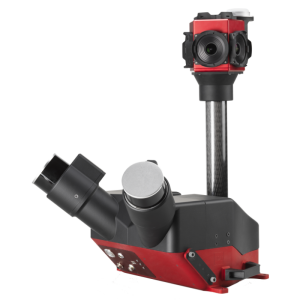
Empower your projects with Meridian's seamless integration of the Mosaic X camera and RESEPI LiDAR/IMU, delivering stunning imagery and accurate data in perfect harmony.
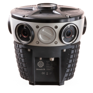
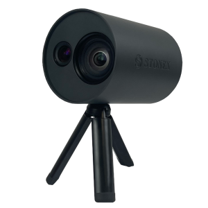
Mosiac X Camera
74MP Resolution
Global shutter sensors
10FPS, 8 bit h.264
Removable USB 1TB SSD
21 x 21 x 25 cm, 7kg
IP64, 0–45°C, 0–100%
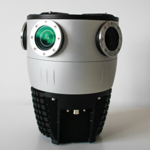
RESEPI LiDAR/IMU
Accuracy: 2–3 cm
Precision: 2–4 cm
Range 80 m
512GB SSD
21.6 x 17.8 x 13 cm
IMU: Inertial Labs Kernel-210
GNSS: NovAtel OEM7720
Position Accuracy: 1 cm + 1 ppm (RTK); 0.5cm (PPK)
More information
check out the Meridian Features
our customer stories
follow us on LinkedIn
check out cool videos
other products: Mosaic X, Mosaic Xplor, and Mosaic Viking
contact us: [email protected] or [email protected]
all interested parties can contact us here:
https://www.mosaic51.com/#contact
Specifications
-
General
-
Year of initial introduction
2024
Year of last update
2024
-
Positioning
-
GNSS receiver: Brand and model
NovAtel OEM7720
IMU: Brand and model
Inertial Labs Tactical Grade IMU-P
IMU update rate [kHz]
2000
Number of antennas
2
Tracked GNSS signals
8
-
Lidar Sensor
-
Brand
RESEPI™ by Inertial Labs
Max Range [m]
80
Number of laser scanners
32
-
Camera System
-
Brand and model
Mosaic X
FoV per camera [deg]
360
Number of cameras
6
Pixel size [micron]
2.74
Maximum frames/sec. per camera
10
Export formats
* 8 bit h.264 compressed * 12 bit RAW (experimental -- low FPS)
-
Dimensions & Environment
-
Weight [kg]
9
Documents
Brochure
Mosaic Meridian Mobile Mapping System Brochure.pdf
3.11 MB


