Mosaic 51: 12K 360 Camera for Mobile Mapping and Street View / Ladybug 5 successor
Most robust, all-in-one, HD, 360 degrees camera for mobile mapping
The most durable, precise and practical 360 degrees camera for urban mapping and surveying. All-in-one solution for mobile mapping and street view data collection.
Mosaic 360 Camera Systems
Czechia
Description
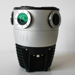
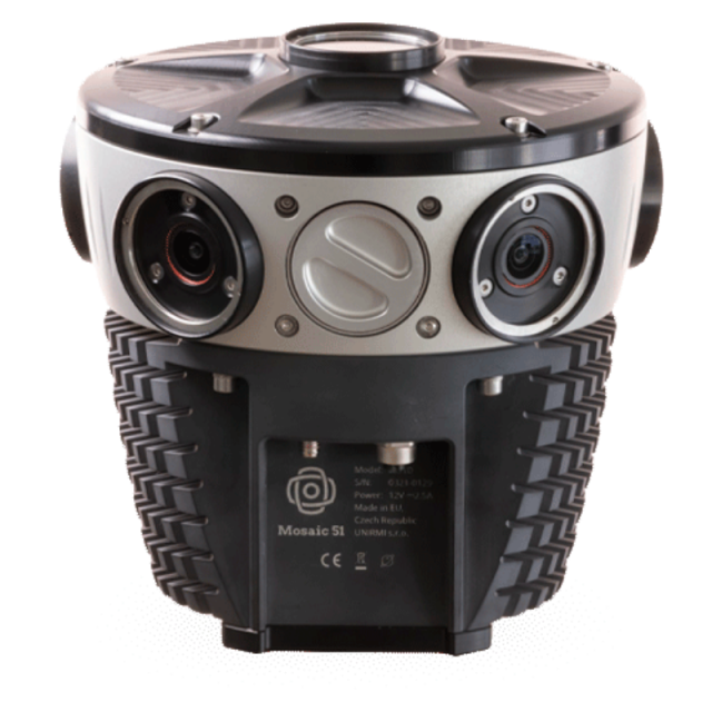
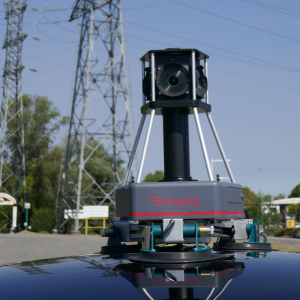
Mosaic 51
Built from the ground up to be the most durable and future proof 360-degree mobile mapping camera on the market.
The most robust
industrial-grade housing
IP67, fully sealed and water-resistant housing
passively cooled
protected, easily replaceable lens covers
light-weight, take it anywhere
The highest definition
6 x 12MP sensors, 72M equirectangular
360-degree view
perfect overlap for optimized overlap and resolution
Future-proof
built in CPU and GPU allows for AI integration, real-time image processing
no vendor lock in
Industries
Smart Cities
Local / Central / National governments
Utility companies
Telecommunications companies
Transportation and logistics companies
Real estate companies & developers
Financial and insurance companies
Engineering and architecture firms
Automotive industry
Railways
Infrastructure surveying
Public safety
Media & entertainment
Use Cases
Street view data collection
GIS updating
Road infrastructure maintenance and repair
3D scanning, modeling and reconstructions
Street signs, lights, and other street furniture maintenance and repair
HD mapping
Train rail inspection
Infrastructure inspection and maintenance
BIM/CAD modeling
Real estate asset management
Property valuation
Cadastral surveying
Agricultural inspection
More information
check out the Mosaic 51 features: https://www.mosaic51.com/cameras/mosaic-51/
electrical grid and road inspection with the Mosaic 51 and LiDAR: https://www.mosaic51.com/industry/case-study-mosaic-customer-dymaxion-integrates-mosaic51-camera-with-lidar/
our customer stories: https://www.mosaic51.com/case-studies/
follow us on LinkedIn: https://www.linkedin.com/company/mosaic-360-geospatial-imaging-leaders
check out cool videos: https://www.youtube.com/channel/UCrh7tggJinvjRWU2N-ee_vw
other products: Mosaic X and Mosaic Viking
contact us: [email protected] or [email protected]
all interested parties can contact us here:
https://www.mosaic51.com/#contact
Specifications
-
General
-
Year of introduction
2020
Length [m]
0.2
Width [m]
0.2
Standard compliances [ISO or others]
n/a
Environmental protection
IP67
Weight [kg]
4.5
Housing Material
Aluminum, Plastic
-
Operation Characteristics
-
Operating temperature: min. [°C]
-20
Operating temperature: max. [°C]
50
Humidity range [%]
100
-
Power Supply
-
Battery type
12V
Operation time on fully charged battery [h]
8
Recharging time of battery [min]
120
External Power Requirements
12V
Power consumption [W]
30
-
More information
-
Training facilities
Yes
Main applications
Mapping, Surveying, Infrastructure Inspection, 3D scanning, Photogrammetry
Distinguishable features
Protected lenses
-
Optics and Sensors
-
Number of lenses
6
Focal length of lenses [mm]
16
Sensor type
Sony
Resolution of one sensor
4000x3000
Field of view of one camera [degrees]
125
Dynamic range [bits]
12
Max. shutter speed [s]
100000
Max number of frames per second
60
-
Functionality
-
Video
Y
Microphone
N
Photo resolution [mp]
12
Geo-referencing of images
Y
Type of positioning system
GPS, GLONASS, BEIDOU, GALILEO
Mounting possibilities
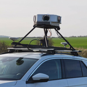
car, backpack, tripod
Environmental sensors
IMU
Trigger modes
photo, video
Camera control
wifi, cable
Max number of images p second
60
-
Data Storage, Software and Connectivity
-
WiFi
Y
Bluetooth
N
Firewire
N
USB
Yes
Other ports
Gigabit Ethernet
Type of data storage
Internal removable m.2 SSD up to 2TB or any external USB 3.0 storage device via waterproof military-grade cable connector
Storage replaceble
Y
Max data storage [Mb]
16000000
Image data output and formats
h.264, Compressed 12-bit RAW
Data transfer rate
from 60 Mbps to 5Gbps
Documents
Brochure
_Mosaic-Mobile-Mapping-Cameras-Brochure-Apr.2024.pdf
1.62 MB


