
Mosaic Xplor: Fully spherical 360º Mobile Mapping Backpack Camera with LiDAR and GNSS
Trailblazing portable reality scanning leading the way in Geospatial, Surveying, and Entertainment
Explore, capture, and analyze challenging-to-reach environments like industrial facilities, factories, pedestrian zones with the ease of highest-resolution laser and photogrammetric scanning.
Mosaic 360 Camera Systems
Czechia
Description
Explore places you never could before - safely, on the move, and in higher resolution
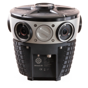
Latest gen 1-inch SONY global shutter sensors (6 x 12.32MP)
14K Equirectangular pano
10fps h.264 (120Mbps / sensor)
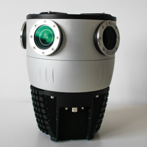
Cutting-Edge 360º x 120º LiDAR Capture
2 LiDAR x 200,000 precision within 40 meter range (max 70m)
Point cloud accuracy: 5cm accuracy and 3 cm precision
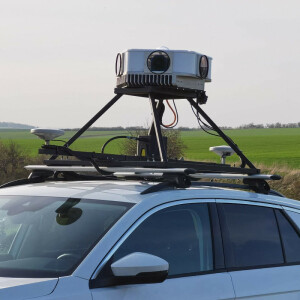
Authentic and precise image capture at speeds up to 25 km/h
Best-in-class lenses
Spatial accuracy < 2 mm at 10 m
Onboard GNSS
AUX Port to connect external devices (i.e. GNSS/INS)
Sealed, water and dust resistant housing
Protected lens, easily replace lens covers when scratched
Onboard hot-swappable USB 3.0 storage
External storage over ethernet via NFS or Samba
The camera has been carefully and deliberately designed to work well in the most demanding environments
Robust housing:
industrial grade waterproof connectors
protected lenses which can withstand harsh daily use
Our optical design ensures:
sharp images at all angles, without a drop off in resolution at the edges (from which other cameras using fisheye lenses might suffer)
a balance between uniform sharpness without using too many image sensors.
Other design considerations:
removable, swappable storage
control via web browser for simple onboarding and handling of operations for any staff member
More information
check out the Mosaic Xplor features: https://www.mosaic51.com/products/mosaic-xplor/
our customer stories: https://www.mosaic51.com/case-studies/
follow us on LinkedIn: https://www.linkedin.com/company/mosaic-360-geospatial-imaging-leaders
check out cool videos: https://www.youtube.com/channel/UCrh7tggJinvjRWU2N-ee_vw
other products: Mosaic X, Mosaic 51 and Mosaic Viking
contact us: [email protected] or [email protected]
all interested parties can contact us here:
https://www.mosaic51.com/#contact
Specifications
-
General
-
Year of introduction
2023
-
More information
-
Distinguishable features
Portable Mapping Backpack with 14K Resolution 360 camera and 120º LiDAR Capture
Main applications
Capture, and analyze hard-to-reach environments and create 3D reconstructions
-
Optics and Sensors
-
Focal length of lenses [mm]
2140 px
Max number of frames per second
10
Number of lenses
6
Resolution of one sensor
4096 x 3008 = 12.32 MP
-
Functionality
-
Geo-referencing of images
Y
Microphone
N
Mounting possibilities
Backpack camera
Trigger modes
* Time * SW message (REST API) * Trigger pulse (opto-isolated IN) * Distance (algorithm running in the camera)
-
Data Storage, Software and Connectivity
-
Bluetooth
N
Image data output and formats
* 8 bit h.264 compressed * 12 bit RAW (planned Q4 2023)
Storage replaceble
Y
USB
Yes
WiFi
N
Documents
Brochure
Mosaic Xplor Mobile Mapping Backpack Brochure.pdf
3.87 MB


