What a Great Impact Has SBG’s ELLIPSE2-D in Turning Shuttle Into Autonomous Driving in Area Known as a “Very Difficult Area for GNSS
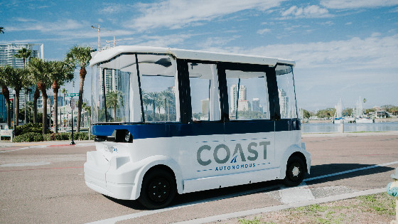
Coast Autonomous, a company providing self-driving mobility solutions such as autonomous golf cart or utility vehicles, integrated SBG Systems’ Ellipse2-D inertial navigation sensor in their most recent P-1 shuttle.
Driverless Transportation Solution in Urban Environments
It is with the idea of “giving back the city to people” that Coast Autonomous invented the P-1 self-driving shuttle. This shuttle has been designed to move people in pedestrian areas, such as urban environment or campuses. It can operate in mixed traffic as well as on high-speed lanes.
Three important features for the development of such a shuttle are safety, passenger experience, and appropriate speed, with the vehicle always analyzing its surroundings to determine its speed and behaviour. COAST AUTONOMOUS technology ensures and safe and comfortable ride at varying speeds with smooth stop.

The solution has been successfully tested more than 60 times in seven countries, safely transporting more than 120,000 passengers. One of the trials took place in the crowded pedestrian area of Broadway in New York City, known as a “very difficult area for GNSS.”
Determine Shuttle Location and Direction
The company elaborated a fully-integrated 6-Level Autonomous System including robotics and artificial intelligence (AI), fleet management and supervision, as well as localization and mapping. While a robotic software controls the shuttle, an artificial intelligence determines how the vehicle should behave and take decisions based on its environment.
As for mapping and localization, the company does not only rely on GPS/GNSS or beacons for navigation. They built a whole system using 7 different technologies, such as inertial and SLAM, that allows the shuttle to navigate indoors and even in harsh conditions such as near buildings or under canopies. As these technologies are complementary, the system is able to determine the best one to use at a specific moment or in any environment.
The seven localization layers are:
• SBG Ellipse2-D RTK GNSS/INS with dual antenna GNSS with speed sensor
• Odometry for dead reckoning
• 2D LiDAR SLAM
• 3D LiDAR SLAM
• Optical SLAM
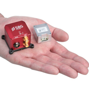
RTK GNSS/INS Becomes Smaller & Cheaper
The Ellipse2-D was an Inertial Navigation System integrating a dual antenna and dual frequency RTK GNSS that was also compatible with our Post-Processing software Qinertia. As the whole Ellipse Series product line has recently been renewed, this solution is now replaced by the Ellipse-D 3rd Generation. This new INS/GNSS conserves all its previous features a smaller size and weight package and embeds a powerful 64bit architecture allowing high-end filtering. Power consumption has also been reduced. Designed for automobile applications, it can fuse Odometer input with Pulse or CAN OBDII for enhanced dead-reckoning accuracy.
Do you have questions about this case study?
Get in touch with SBG Systems, and they would be happy to answer any questions you have about pricing, suitability, availability, specs, etc.
Related products


![Do-Giant-Tortoises-Make-Good-Neighbors-1[1].jpg](https://cdn.geo-matching.com/vRMO2Edp.jpg?w=320&s=a6108b2726133ff723670b57bc54c812)


