Navsight INS Used for Multi-Beam and Laser Survey Onboard USV
"Navsight Apogee provides exceptional performance when used in our nearshore and offshore surveys. Combined with its low power, small installation footprint and short initialisation times it’s the perfect solution for all USV operations" - James Williams, Director USS
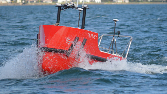
The Scalable Accession Class USV
The UK-based company Unmanned Survey Solution (USS) has created a very unique Unmanned Surface Vessel called the “Accession Class USV”. Designed to meet the surveyor's needs for today and tomorrow, this USV incorporates a modular design that offers three variable boat lengths depending on the desired application. The base boat length of 3.50m can be extended to 4.25m or 5.00m by adding additional hull sections.

Fully Equipped for Hydrographic Applications
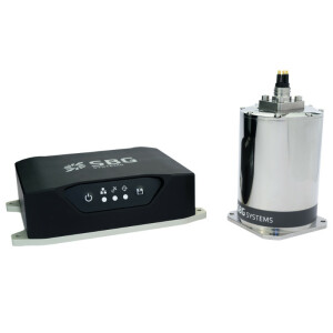
The standard USV Hydrographic payload includes the highest industry standard sensors to meet IHO special order surveys. These consist of an R2Sonic SONIC 2024 Multibeam sonar, an SBG Apogee Navsight Inertial + GNSS solution, and Valeport MiniSVS & SWIFT SVP for measuring sound velocity. The data is acquired in either Hypack or QINSy Hydrographic software and utilized for mission planning, data acquisition, post-processing, and final products. Ideal for operations in both nearshore and offshore environments, this un-crewed platform is safer and more cost-effective than comparative manned vessels.
Adding a Lidar for a Full 3D Environment
Although the Accession USV is payload agnostic and fully customer configurable, the standard configuration can also be interfaced with a mobile Lidar such as the Carlson Merlin laser scanner for mapping terrestrial structures to create a full 3D point cloud above and below water. This is only achievable by using the embedded SBG Inertial Navigation System (INS) which is extremely versatile for both shallow and deeper water regions in either the open sky or challenging GNSS environments such as under bridges and tree canopies, or in urban regions where tall buildings often obscure the GNSS horizon. In such situations, the centimetric level RTK position accuracy is greatly improved using SBG’s post-processing software called Qinertia. This PPP and PPK-capable software offers single or virtual base station modes and can even incorporate users’ own base station RINEX data.

Conway quay wall, Conway bridge and Cob were surveyed using the Accession 350 USV, SONIC 2024, Apogee Navsight and Merlin Laser
Do you have questions about this case study?
Get in touch with SBG Systems, and they would be happy to answer any questions you have about pricing, suitability, availability, specs, etc.


![Do-Giant-Tortoises-Make-Good-Neighbors-1[1].jpg](https://cdn.geo-matching.com/vRMO2Edp.jpg?w=320&s=a6108b2726133ff723670b57bc54c812)


