

Mobile Mapping for Recurrent Data Collection Along the French National Railway Network
It is now been 2 years that the french main railway network -54 000 km of tracks- is permanently surveyed and mapped with imajbox mobile mapping technology. The systems are installed onboard each geometry control trains of the railway and collects a huge amount of geo-referenced, oriented and calibrated images along the tracks at production rate of 18 000 kms per month. After post processing and publication, fresh data are available for all the agents of the french railway operator SNCF Réseau. Today, thousands of them are daily using the data and imagery collected either from the office, integrated into internal business applications or directly on the field with a smartphone app.
Data acquisition
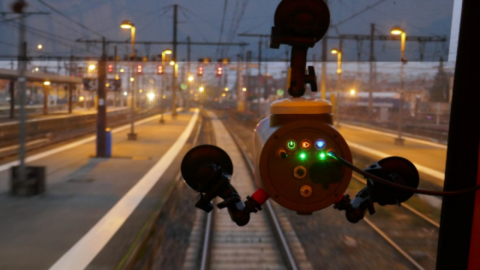
The data acquisition is continuous and performed every day, from morning to evening. imajbox 2T technology is mounted at the front and the back of the trains, inside the cabins, with a centralization of the acquisitions on our Multiview system via an Ethernet connection. imajbox 2T is a CCD camera of 5M pixels, 80° HoFV. The positioning technology merges data from a set of sensors to ensure accurate and continuous positioning, even in case of complete loss of GNSS signal.
The acquisition is completely automated : no intervention from the staff is required, except to switch on/off and replace the SSD storage unit approximately once a week.
Data post-processing and quality control
The data post processing and quality control is organized on a weekly baseline with between 2,500 and 4,500 km surveyed per week, representing 4.5 Tb of raw data per month. Image positioning is computed during the post-processing, and uses multiple GNSS constellation corrected with differential corrections obtained from the RGP (IGN base station network covering the French territory).
The final navigation solution comes from the fusion of corrected GNSS data and inertial data, providing a continuous positioning even when getting across tunnels (leading to GNSS signal loss).
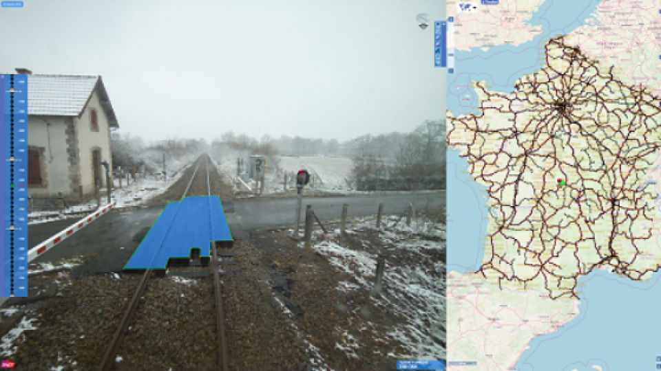
Published surveys on imajnet platform
Once collected and post-process, the surveys are published on imajnet® platform to make them available for SNCF Réseau staff.
In addition to surveys, the complete topology of the network and all kilometric points (milespost) are published to enable the real time computation of linear position from geographic coordinates.
Lastest and past surveys are all accessible in different applications :
- Viewing and interacting, web.imajnet.net : to synchronize background maps and surveys, locate, navigate, measure in the images, position, digitize any element (point, line or polygon) in 3D in the images and export.
- Immersive view integrated into SNCF Réseau internal tools with JavaScript SDK, currently serving more than 10 different applications
- On the field, locating with LRS app : this application uses the phone GPS and converts on the flight the current geographical positioning into linear coordinates. It is used on the trains for inspections, on the field for locating during operations, and in cars for locating access to target point on the network.
- The set of tools giving access to up-to-date surveys are used for many tasks of the organization:
- for works and maintenance project managers : site preparation, asset inventory, work preparation and control, pruning projects;
- for engineering activities: signaling programs planning, telecom studies, catenary studies, ETCS studies, railway crossing work preparation studies…
The global capture of calibrated accurate imagery serves a wide range of users from maintenance, planning, GIS, engineering and management, in the field or in the office, saving hours of field data collection or field control to all the organization.
After 2 years of operation, both imajing and SNCF Réseau consider that the project brings much more than what was expected to the company.
Do you have questions about this case study?
Get in touch with imajing, and they would be happy to answer any questions you have about pricing, suitability, availability, specs, etc.


![Do-Giant-Tortoises-Make-Good-Neighbors-1[1].jpg](https://cdn.geo-matching.com/vRMO2Edp.jpg?w=320&s=a6108b2726133ff723670b57bc54c812)


