Direct Georeferencing Solution Delivers High-Accuracy Post-Processed Surveying Data
Combining their years of expertise and industry experience, Applanix and Microdrones came together to give surveyors a turnkey solution that delivers high-accuracy post-processed data. The solution was a full hardware and software solution for aerial mapping from a UAV that allows the creation of survey-grade point clouds in difficult terrains with a simplified workflow that seamlessly takes you from capturing data to downloading fully post-processed high-accuracy data.
The Challenge
Surveyors tasked with collecting and analyzing data from the field can face a myriad of challenges. From inclement weather to uneven terrain, paired with the added inefficiencies of inputting and then analyzing data, a standard survey project can easily extend to several days of work.
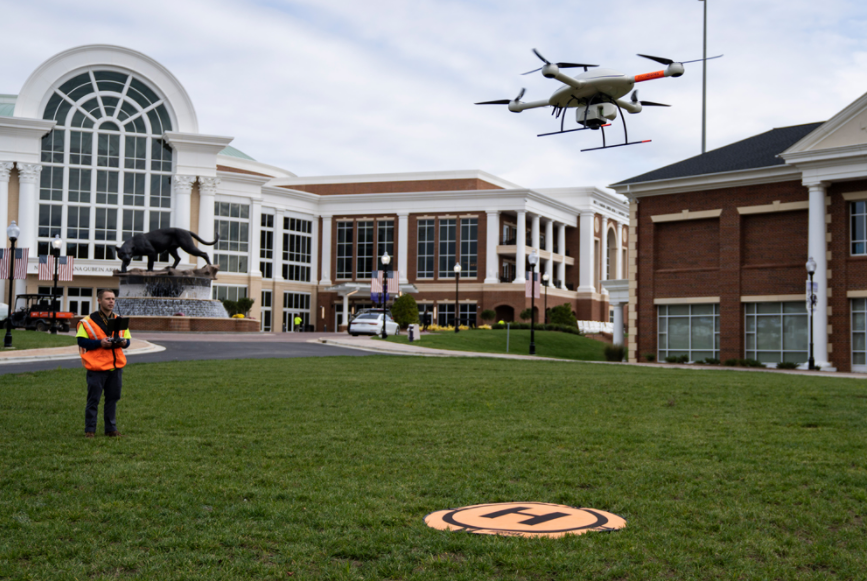
Utilizing a drone or other uncrewed aerial vehicle (UAV) to survey an area can be an alternative option to avoid demanding environments in the field. But Microdrones®, a leader in drone Lidar and photogrammetry surveying equipment and software for geospatial collection and processing, was challenged to deliver point cloud data according to updated survey-grade standards.
The Solution
Microdrones needed an expert in Direct Georeferencing solutions for UAV implementation and a partner who understood multiple sensor implementations. So Microdrones contacted Applanix, a Trimble® company and a leader in high-accuracy Direct Georeferencing of Lidar data.
Together, Microdrones and Applanix integrated Applanix’s POS (Positioning and Orientation) technology. As a prerequisite to implementation, Applanix needed to meet specific requirements to reduce the weight of the hardware while keeping the accuracy and performance of the inertial measurement unit (IMU). Applanix’ APX UAV solutions were designed with this in mind, high accuracy georeferencing units that meet the size/weight/power requirements of a UAV, resulting in professional survey-grade aerial mapping solutions for a UAV.
Lidar point cloud of an office building
The Approach to a Working Solution
The partnership began by combining the powerful and versatile airframe from Microdrones with industry-leading Lidar georeferencing technology from Applanix. This initial step offered cost and time efficiencies for many mapping tasks. Microdrones could provide their geospatial customers with a fully integrated system to rapidly capture accurate Lidar data for surveying, mining, construction, oil and gas and precision agriculture industries.
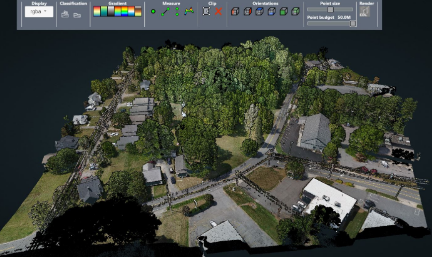
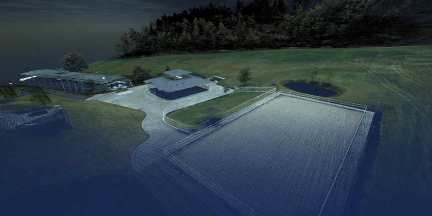
Lidar point cloud of a neighbourhood view within the software
Seamless Workflow With Cloud-based Data Processing Through POSPac UAV Cloud
Following the success of their initial collaboration, Microdrones and Applanix moved to empower customers to deploy the full hardware and software solution. Incorporating Applanix’s GNSS IMU technology allowed Microdrones to seamlessly integrate GNSS-inertial data processing as part of the overall mapping workflow. Additionally, by integrating the Applanix POSPac Cloud system, Microdrones gave surveyors access to the most accurate and simplified georeferencing data in post-mission. By simplifying the workflow - fly the drone, uploading the data to the POSPac cloud, and then downloading the final data - Microdrones was able to capture a broader client base beyond early adopters. The quick, uncomplicated and inexpensive process made it easier and more affordable for surveyors to have access to everything for complex surveying work.
With Applanix’s integration, Microdrones now deliver a range of advantages via mobile mapping from the air:
- Improved safety
- Highly accurate mapping
- Efficient workflow
- Turnkey integrated solution
Working together, Microdrones and Applanix have created a first-of-its-kind affordable solution for surveyors to gain access to drone Lidar technology.
Prior to Applanix’s partnership with Microdrones, it was cost-prohibitive for small to midsize companies to invest in high-quality, accurate drone Lidar technology. Now, surveying professionals can afford a high-quality product like the mdLiDAR1000HR to complete survey projects quickly, safely and profitably while using MD Infiniti to process geospatial data quickly and efficiently.
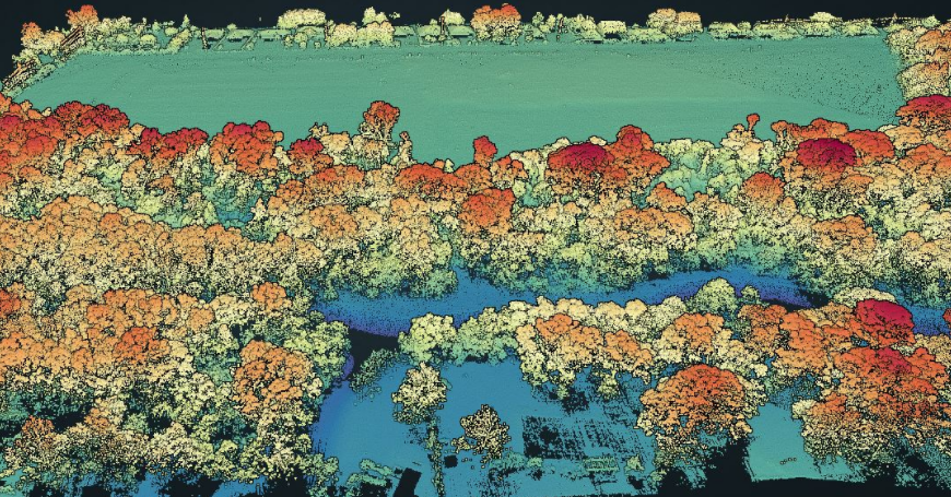
Lidar Point Cloud of Tree Canopy
About POSPac UAV Cloud
POSPac Cloud is a cloud-based version of POSPac MMS/ POSPac UAV available to OEMs. POSPac Cloud allows seamless integrations of GNSS-inertial data processing for OEMs as an integrated part of the overall mapping solution. The interface to the cloud service is performed via an API, enabling data collected from the Applanix hardware (e.g. the APX OEM boards) to be processed through the internet. POSPac Cloud SaaS (software as a service) employs a pay-per-use model.
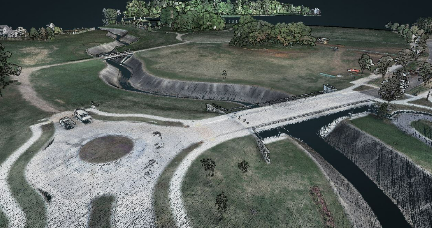
Lidar Point Cloud or Road and Bridge
Do you have questions about this case study?
Get in touch with Trimble Applanix, and they would be happy to answer any questions you have about pricing, suitability, availability, specs, etc.


![Do-Giant-Tortoises-Make-Good-Neighbors-1[1].jpg](https://cdn.geo-matching.com/vRMO2Edp.jpg?w=320&s=a6108b2726133ff723670b57bc54c812)


