


Creating a 3D Model of a Shooting Range Using Point Cloud Processing Software
One of our clients - CDJ Land surveyors were asked to measure out a shooting range as accurate as possible as the shooters of the range was complaining that the range was in fact not level enough and that they could not see the targets at the end of the range due to the uneven surface.
On the terrain, there was quite a number of high and low points they could not miss and did not want to risk it by doing it the old conventional method because they might miss a few critical high and low points which could have been crucial, so they rather opted to make an accurate representation of the ground in the form of a 3D model in order for the shooting range to run the simulations needed to see how they can create the best shooting environment for the shooters.
To do the survey they had to keep the following information in mind:
A no danger area outdoor range shall be constructed or designed in such a way that no misdirected shot, that can reasonably be expected to be fired towards the targets, will leave the range.
They needed to identify outdoor danger area ranges are ranges where the stop butt (only outdoor ranges can have danger areas) is not sufficiently high and/or wide to meet the requirement to contain all reasonably expected misdirected shots. Outdoor danger area ranges shall have a danger area beyond the stop butt. In the case of shotgun ranges there is no stop butt, and the danger area then naturally is the area where all the shot impacts.
You also get different outdoor ranges depending on their intended use, backstop construction etc.
Standard Range uses a rifle or handgun range that has a suitable backstop and an adequate safety area but does not have a downrange shelter for target systems and/or target marking personnel.
Gallery Range A rifle range, built to Standard Range specifications, with a downrange shelter for target systems and/or target marking personnel.
Baffled Range A handgun or rifle range whose design has incorporated a series of overhead and/or ground baffles, or similar construction features, that serve to contain all fired bullets and ricochets to the active range area. This type of range may have a downrange shelter (gallery) for target systems and/or target marking personnel.
No Safety Area Range A handgun or rifle range built with its direction of fire into an imposing natural (or man-made) feature that prevents overshoots and ricochets from escaping the immediate range area.
Skeet and Trapshooting Ranges Shotgun ranges designed for shots to be discharged at moving frangible targets thrown on fixed flight paths or within prescribed arcs.
Sporting Clay Range A shotgun range designed for shots to be discharged at moving frangible targets thrown on fixed flight paths or within prescribed arcs. However, the range setting is one that is designed to simulate hunting or field situations.
Field Firing Range A rifle or handgun range that does not have any backstops (or has a backstop that is not adequate); however, the range has an adequate safety area. An adequate downrange safety area is one that has the necessary depth and width to accommodate the appropriate safety template(s) needed for the range’s intended use.
RANGES SAFETY AREAS is what they needed to keep in mind.
Dependent on the range design and the intended range use, a downrange safety area may (or may not) be required. The decision about whether or not a safe area is required, or how big the safety area needs to be, will be based on an assessment of the intended range operations and range construction. If the range design and intended operations are such that: Ø Fired projectiles or subsequent ricochets are able to leave the active range area (under normal operating conditions), then a downrange safety area is required; or, Ø Fired projectiles and subsequent ricochets will be contained within the active range area (under normal operating conditions), then a downrange safety area is not required.
SAFETY AREA DEFINITION - The safety area for an outdoor range is defined as the downrange area (forward of the firing point) that is designed to contain bullets that pass over, or beyond, the backstop under specified conditions. These bullets can be the result of high angle shots (overshoots) or bullets that ricochet off-targets, the backstop and other range surfaces (e.g. the range floor). Safety areas are very important considerations in outdoor range design; however, they are concerned strictly with ballistic issues and do not address the issue of noise pollution.
OVERSHOOT AND RICOCHET PROJECTILES - An overshoot is defined as a bullet (or projectile) that carries over, or beyond, a backstop that was intended to stop it. By definition, an overshoot projectile will not have struck any downrange object before travelling beyond the backstop. Overshoots are distinctly different from ricochets. Ricochets are bullets (or projectiles) that have struck a surface or object and had their trajectory altered as a result. Ricochets may or may not clear the backstop; however, due to their unpredictability, a worst-case scenario will be applied.
With all this information they knew they needed to be spot on with their survey, and they decided to use the following equipment for their survey.
In order to do this, they first needed an accurate plan to recreate the environment. They used the following tools to conduct the survey:
- SOM Reach RS2 Complete surveying kit
- Phantom 3 Pro
- 3Dsurvey Software
- GCP targets.
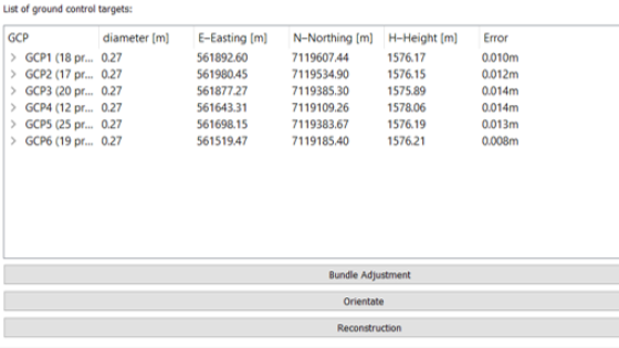
Based on this equipment they could get the following dataset:

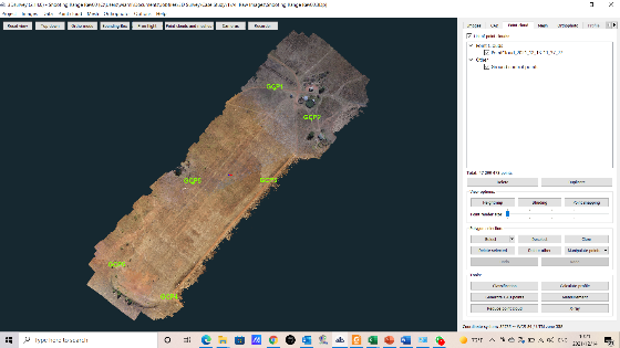
In this image we could clearly see the positioning of their GCPs as well as their flight grid, they actually did a double grid over the area to ensure they do not miss any areas with insufficient overlap, the side grid was used for processing while the rest was removed.
Based on their GCP points they could typically expect the following accuracy in the survey which met their requirements:
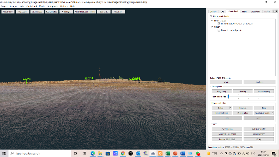
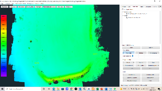
They processed the job and was able to see the following results:
A very nice and accurate top view and shooter's view with the end bank in clear sight.
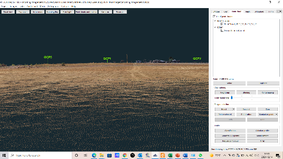
A clearer view of the bank from the shooter's position.

Another image of the high wall in more detail.

A view back to the shooters position.
A good height map of the area:
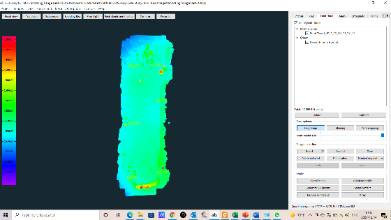
What we could see from this height map is that the light blue indicates low points on the sight. and we can see there is a few places down the range that is in fact higher and also lower that the shooters position. They would need to eliminate the high and low points of the terrain to give the shooter the best ability to make an accurate shot being able to see all the surroundings and places on the retain.
We can see that close to the target area is a darker green which means it is higher and then after that it is a light blue meaning lower again.
So this would mean that the shooter might potentially not have the ability to see the target at the furthest point of the sight.
Example of what needs to be eliminated:

The equipment used was able to point out all this information to the client and they are currently in the process of making this a world-class shooting range.
Author: SOM Survey Instruments 2022
Do you have questions about this case study?
Get in touch with 3Dsurvey, and they would be happy to answer any questions you have about pricing, suitability, availability, specs, etc.

Related products


![Do-Giant-Tortoises-Make-Good-Neighbors-1[1].jpg](https://cdn.geo-matching.com/vRMO2Edp.jpg?w=320&s=a6108b2726133ff723670b57bc54c812)


