
Building a Sewage System Using A Drone-based 3Dsurvey Map
Most surveyors combine their work routine between the terrain and office work. Often, the result of such work is a survey map. 3Dsurvey software was developed by surveyors for surveyors, who realised that the work process could be done much faster with new technology. The work process is usually done in two steps – first, they gather information and measurements on the terrain and all these figures are then later on used to produce maps. The following showcase will briefly explain the benefits of the 3Dsurvey software.
TRADITIONAL SURVEYING
The traditional terrain work is usually time-consuming because there are a few steps that need to be followed in order to get best results: measurements of the terrain, objects on the terrain, municipal infrastructures and of natural barriers.
The main issues of traditional surveying and NON-UAV-based survey work:
- For one simple residential building, the work on the terrain could take 2 hours or more. However, for larger areas, as for example 1km of a road in a fairly inhabited area, it could also take everything from 1 to 3 days.
- By accident, it can often happen that some major detail points are not measured. In this case, the surveyor has to return back to the terrain and measure the missing information.
- Still, most of the measurements are done by “hand” – point by point: the surveyor visits the terrain and draws a sketch of the terrain and after that, he draws in the points which have to be measured.
UAV BASED SURVEYING
This case is showing a modern state of the art company’s work case, which made a project for the selected area for the purpose of building a sewerage system. For completion of this project, they needed to measure the area in order to make a survey map which then served as a basis to complete the project.
Technical characteristics:
- The length of the road: 1.3km
- Size of the area: 20 Ha
- Number of flights: 3 flights (1250 photos taken)
- Number of GCPs: 24 – measured with a Total station
- Flight height: 80m

Work flow:
Terrain
- Placing and measuring of the GCPs on the terrain (24)
- Measuring of certain details, which are hard to determine on the point cloud – as for example corners of some buildings. All other details were obtained on photogrammetry data. There was no need to do a sketch of the terrain beforehand.
- Drone overflight to measure the data.
Time spent on the terrain: 8 h, 2 persons
Office
- Calculation of the data in a classic way - GCP points and corners of the buildings.
- Calculation of the data from the drone (photos were taken from drone) and afterwards calculating:
- Point Cloud
- Digital Surface Model
- Orthophoto
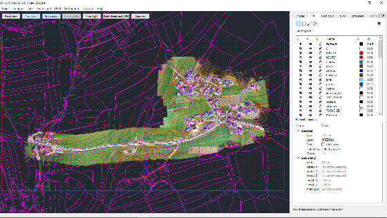
- Obtaining analytical data with the aid of 3Dsurvey software:
- Contour lines – DSM tab
- 3D characteristic lines (roads, escarpment, cultural borders, buildings, additional objects, manholes, fences…)
- Spot elevation points


Prepared CAD data in the 3Dsurvey are directly compatible with most of the other CAD software. In this case, we exported layers as .dxf* and then we imported them in the Auto Cad.
- Adding topographical signs (manholes, electricity, canalisation, public lightning,...), banks and all types of objects.
- Preparation for printing.
To sum up: the terrain work is more than 3 times faster than in a traditional way.
Timewise the office work is similar to before because more data has to be taken into calculation. However, the results are much more complete and visually upgraded. The final results include the surrounding area of the territory which was measured, meaning that there is no need to revisit the area. Any additional information is one click away and easily done from the office. The result is an all in one solution: CAD drawing, accurate digital surface model and high-resolution orthophoto, which are very valuable and indispensable tools for every constructor.


Do you have questions about this case study?
Get in touch with 3Dsurvey, and they would be happy to answer any questions you have about pricing, suitability, availability, specs, etc.


![Do-Giant-Tortoises-Make-Good-Neighbors-1[1].jpg](https://cdn.geo-matching.com/vRMO2Edp.jpg?w=320&s=a6108b2726133ff723670b57bc54c812)


