
VQ-880-GII / VQ-880-GH
Topo-Bathymetric Airborne Laser Scanning System with Online Waveform Processing and Full Waveform Recording
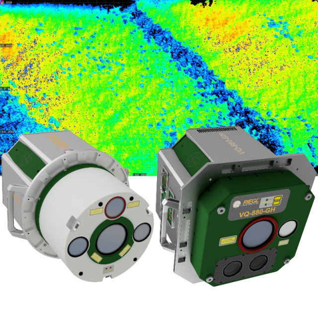
The VQ-880-GII / VQ-880-GH carries out laser range measurements for high resolution surveying of underwater topography with a narrow, visible green laser beam, emitted from a powerful pulsed laser source. Subject to clarity, at this particular wavelength the laser beam penetrates water enabling measurement of submerged targets.

RIEGL | Innovation in 3D
Horn, AT
Description
Based on the proven topo-bathymetric airborne laser scanning system VQ-880-G, RIEGL now presents the VQ-880-GII / VQ-880-GH, which impresses with the improved performance of the IR channel and offers a new form factor with enhanced camera configuration. The system's design allows a flexible application of the integrated, factory-calibrated high-end GNSS/IMU system and up to two cameras to meet specific requirements. Complemented by a RIEGL data recorder, the LiDAR system can be installed straightforwardly installed on various platforms.
The VQ-880-GII / VQ-880-GH carries out laser straightforwardly installed on various platforms measurements for high-resolution surveying of underwater topography with a narrow, visible green laser beam emitted from a powerful pulsed laser source. Subject to clarity, at this particular wavelength, the laser beam penetrates water, enabling measurement of submerged targets.
Do you have questions about this product?
- Questions about price, availability, and/or retailers
- Questions about technical specifications and usage
- Questions about suitability for your project or application
Specifications
-
General
-
Year of introduction
2018
Year of last update
2018
Total Weight [kg]
65
Power requirements
18-32V DC, 330W
Type of GNSS/INS positioning system
optional
Camera
RGB and/or IR camera
Data storage facilities
separate dedicated data recorder
Mission planning software
RiPARAMETER,IGI Plan; TrackAir; or similar
Postprocessing software
RiAQUIRE, RiPROCESS, RiUNITE, RiHYDRO
-
Application
-
Main applications
Coastline and Shallow Water Mapping; Acquiring Base Data for Flood Prevention; Measurement for Aggradation Zones; Habitat Mapping; Surveying for Hydraulic Engineering; Hydro-Archeological-Surveying
-
Measurement Characteristics
-
Scanning method
rotating polygon mirror
Min. pulse frequency [Hz]
150000
Max. pulse frequency [Hz]
900000
Max. field of view [deg]
40
Max. number of recorded echoes per pulse
practically unlimited
Full-wave form digitization
Y
multiple pulses in air
Y
Recording of intensity of return signal [bits]
16
-
Operation Characteristics
-
Platform
Helicopter, Fixed-wing, Gyroplane
Min. flying height [m]
10
Max. flying height [m]
1600
-
Laser Pulse Characteristics
-
Type/class laser
3B
-
More information
-
Distinguishable features
• designed for combined topographic and bathymetric airborne survey • green laser scanner with up to 700kHz measurement rate • IR laser scanner with up to 279kHz measurement rate and improved ranging performance • high accuracy ranging based on echo digitization and online wave- form processing with multiple-target capability • multiple-time-around processing for straightforward mission planning and operation • concurrent full waveform output for all measurements for subsequent full waveform analysis for the green channel • high resolution due to high measurement rate • integrated inertial navigation system • up to two integrated digital cameras • compatibility with stabilized mounting platforms
-
Application areas
-
Select an application area:
Hydrography
Documents
Brochure
RIEGL VQ-880-GII Datasheet.pdf
4.46 MB
Other documents
-
RIEGL VQ-880-GH Datasheet4.02 MB
-
RIEGL Topo-Bathymetry Brochure.pdf7.01 MB


