
Geo-MMS LiDAR
GEO-MMS: LiDAR & Photogrammetry Solutions Powerful. Customizable. Cost-Effective.
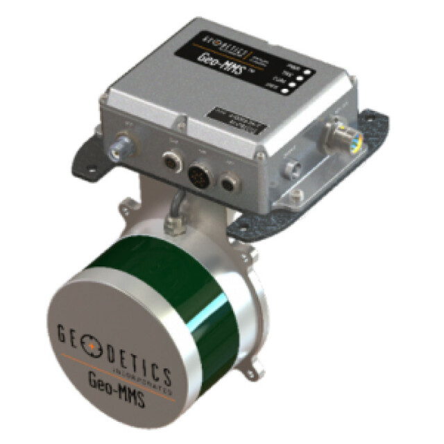
Geo-MMS LiDAR is a LiDAR mapping payload for drone or ground vehicles. Geo-MMS LiDAR includes a high-performance dual-antenna inertial navigation system coupled with an on-board LiDAR sensor. Raw sensor data is processed in real-time or post-mission using Geodetics' extensive software suite to provide high-accuracy directly geo-referenced LiDAR point clouds in the LAS format. Geo-MMS LiDAR is compatible with Geodetics' Point&Pixel product for creating colorized LiDAR point clouds.
AEVEX Aerospace
United States
Description
What is Geo-MMS?
AEVEX’s Geo-MMS (Mobile Mapping System) is a cost-efficient, modular system for drone-based LiDAR and imagery capture solutions. Our three product categories and bundle options cater to various unique applications, use cases and mission challenges. AEVEX’s extensive suite of ‘one-click’ advanced processing software provides a powerful, user-friendly toolbox for mobile and UAV-based mapping operations.
At the heart of Geo-MMS is AEVEX’s dual-antenna Inertial Navigation System (INS), with tight coupling of LiDAR, RGB, multispectral and other sensors. This Defense-grade proprietary navigation technology has been refined over AEVEX’s 20+ year history to a lightweight, platform-agnostic system that can be deployed in minutes.
Geo-MMS Suite of Customizable Products
- Geo-MMS LiDAR
Fully integrated LiDAR payloads for UAV and mobile mapping missions.
- Geo-Photomap
GCP-free photogrammetry utilising RGB and multispectral sensors.
- Point&Pixel
The best Geo-MMS LiDAR and Geo-Photomap rolled into one for simultaneous data acquisition.
- Foundation Solutions.
- Research Solutions.
- Utilities Solutions.
- Ground-Based Solutions.
- Geo-MMS Plus: Advanced UAV Solutions.
Specifications
-
Application
-
Main applications
Intelligence, Surveillance and Reconnaissance (ISR) Situational Awareness Sense and avoid Asset management Coastal surveillance Hydrometric mapping Critical Oil & Gas infrastructure inspection DEM/DSM generation Indoor mapping capable (SLAM) Please view http://geodetics.com/product/geo-mms/ for details.
Distinguishable features
Fully integrated LiDAR mapping payload for integration with small UAVs. Includes an inertial navigation system coupled with a LiDAR sensor.
-
Measurement Characteristics
-
Scanning method
Fixed optic
Range accuracy [mm]
30
Scanning Speed [measurements p second]
300000
Min. pulse frequency [Hz]
5
Max. pulse frequency [Hz]
20
Max. field of view [degrees]
360
Max. number of recorded echoes per pulse
16
Recording of intensity of return signal [bits]
8
-
Physical Properties
-
Height [cm]
5.6
Length [cm]
12
Width [cm]
10
Weight [kg]
1.59
-
Laser Pulse Characteristics
-
Laser Class
1
Wavelength [nm]
903
Standard pulse length [ns]
6
Beam divergence [mrad]
3
Max. range of laser pulse [m]
100
-
Power Supply
-
Power requirements
10 – 30 VDC @ 2 Amps min
-
Positioning System
-
Number of GNSS positioning sensors
1
Type of GNSS positioning sensors
Dual frequency RTK
Typical positioning accuracy [cm]
25
Heading, Pitch and Role internally captured
Y
Gyroscopes Bias In-Run stability [deg p hr]
3
-
Operation Characteristics
-
Mounting
Flexible mounting for different platforms including UAV, UGV, ground vehicles and robots
Requirements for compatible UAVs
The size and weight of the sensor is minimal to meet payload restrictions.
Camera included
No
-
Data and Software
-
Included software
RAW data from the integrated GPS, IMU and LiDAR sensors are recorded on the internal data recording device and can be post-processed using Geodetics LiDARTool software to directly georeference the LiDAR point clouds with LAS format output.
-
General
-
Year of last update
2018
Year of introduction
2016


