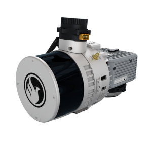
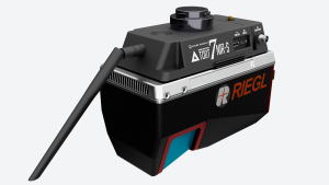
SCOUT-M2X
The SCOUT-M2X Is the Ideal Combination of Performance, Flexibility and Affordability
It brings a new level of precision and accuracy to the long trusted SCOUT lineup of multi-channel mapping scanners.
Phoenix LiDAR Systems
Austin, US
Description
Long range, high pulse rate and triple return capability allow for UAV acquisitions of more data faster through vegetation. Dense survey data can be collected by nearly any method; UAV, Mobile, Backpack, and more. The SCOUT-M2X is also SLAM capable, taking you where others cannot.
Features:
-
Fast and accurate measurements with a 640 kHz pulse rate scanner
-
Live control and feedback during acquisition, including Phoenix’s signature real-time point cloud
-
SLAM (Simultaneous localization and mapping) capable
-
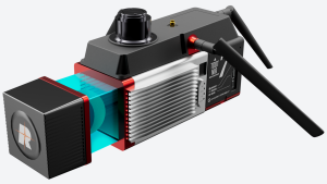
Integrated high resolution camera options up to 61 mp
Quick Specs:
-
Absolute Accuracy = 2-4 cm RMSEz @ 100m AGL
-
Intraswath Precision = 4 cm RMSDz @ 100m AGL
-
Weight = 1.8 kg
-
Dimensions = 17.7 x 11.6 x 12.3 cm
-
Pulse Rate = 640 kHz, Up to 3 returns
-
Line Rate = 5,10 or 20 H
Specifications
-
Application
-
Main applications
stockpile volumetrics, agriculture and forestry monitoring, construction site surveying, open pit mining operations, general mapping
Training, maintanence and support
Provided by Phoenix LiDAR Systems
Distinguishable features
Longest Ranging member of the SCOUT series. Capable of the highest echo return count within SCOUT series
-
Measurement Characteristics
-
Range accuracy [mm]
30
Scanning Speed [measurements p second]
640000
multiple pulses in air
N
Max. pulse frequency [Hz]
640000
Max. field of view [degrees]
360
Max. number of recorded echoes per pulse
3
-
Physical Properties
-
Weight [kg]
1.8
Height [cm]
12.3
Length [cm]
17.7
Width [cm]
11.6
-
Laser Pulse Characteristics
-
Laser Class
Class 1
Wavelength [nm]
905
Min. range of laser pulse [m]
0.5
Max. range of laser pulse [m]
300
-
Power Supply
-
Power consumption
30 W
Power requirements
12-28V DC
-
Positioning System
-
Number of GNSS positioning sensors
2
Type of GNSS positioning sensors
GPS+GLONASS+BEIDOU+GALILEO
Typical positioning accuracy [cm]
1
Heading, Pitch and Role internally captured
Y
Type of INS or IMU
Various
Gyroscopes Bias In-Run stability [deg p hr]
1.0°/hr to 0.5°/hr options
-
Operation Characteristics
-
Camera included
Optional
Mounting
UAV, GROUD VEHICLE, BACKPACK, SLAM
Camera specifications
Various
Control and user interface
Phoenix LiDAR System's SpatialExplorer
-
General
-
Year of last update
2022
Year of introduction
2022
Documents
Brochure
PLS-SCOUT-MX2-Spec-Sheet_2022-10-3_HiResBleedCrops-1.pdf


