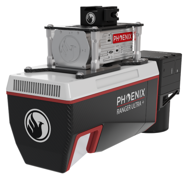
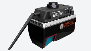
RANGER-ULTRA+
An upgrade to the renowned RANGER-ULTRA with increased range and resolution
The RANGER-ULTRA+ is a cutting-edge mapping system that offers a unique value proposition for professionals in a variety of industries.
Phoenix LiDAR Systems
Austin, US
Description
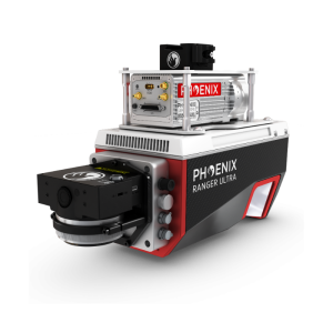
The RANGER-ULTRA+ adds range and density capabilities to an already unrivaled mapping system. It’s unique forward and rear looking field of view was designed to minimize laser shadowing and provide a high level of detail on vertical surfaces.
Pulse rates up to 2.4 MHz and the ability to be carried by a variety of aircraft make this a highly versatile system that is suitable for mapping at various scales in order to meet your unique project objectives. The RANGER-ULTRA+ is ideal for corridor mapping applications such as utility, rail and pipeline inspection.
Features
-
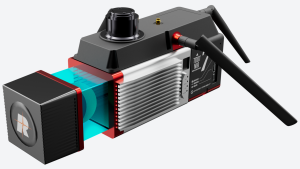
Exceptional data density with measurement rates up to 2,000,000/s
-
3 facet polygon mirror with -10° back, 0° nadir, and +10° forward for improved detail on vertical structures and surfaces
-
Easily mountable to unmanned platforms (UAVs) and to helicopters, gyrocopters, and other small piloted aircrafts
-
100° lateral field of view for single pass corridor coverage
Quick Specs
-
Absolute Accuracy = 1.5 - 3 cm RMSEz @ 120 m.
-
Weight = 3.4 kg / 7.5 lbs
-
Dimensions = 27.5 x 11.7 x 22.2 cm
-
Pulse Rate = 300 - 2400 kHz, up to 32 returns
-
Laser Range = 980 m @ 20% reflectivity
Specifications
-
Application
-
Main applications
Utilities Mapping, Railway Track Mapping, Oil & Gas Surveying, Construction Surveying, Agriculture & Forestry Mapping, Open Pit Mining, General Mapping
Training, maintanence and support
Provided by Phoenix LiDAR Systems
Distinguishable features
The RANGER-ULTRA+ adds range and density capabilities to an already unrivaled mapping system. It’s unique forward and rear looking field of view was designed to minimize laser shadowing and provide a high level of detail on vertical surfaces. Pulse rates up to 2.4 MHz and the ability to be carried by a variety of aircraft make this a highly versatile system that is suitable for mapping at various scales in order to meet your unique project objectives. The RANGER-ULTRA+ is ideal for corridor mapping applications such as utility, rail and pipeline inspection.
-
Measurement Characteristics
-
Scanning Speed [measurements p second]
2400000
Max. field of view [degrees]
100
Max. number of recorded echoes per pulse
32
Range accuracy [mm]
10
multiple pulses in air
Y
Min. pulse frequency [Hz]
300000
Max. pulse frequency [Hz]
2400000
-
Physical Properties
-
Height [cm]
22.2
Length [cm]
27.5
Width [cm]
11.7
Weight [kg]
3.4
-
Laser Pulse Characteristics
-
Laser Class
Class 1
Wavelength [nm]
1550
Beam divergence [mrad]
0.4
Min. range of laser pulse [m]
5
Max. range of laser pulse [m]
980
-
Power Supply
-
Power consumption
75W
Power requirements
12-28 V DC
-
Positioning System
-
Number of GNSS positioning sensors
1
Type of GNSS positioning sensors
GPS+GLONASS+BEIDOU+GALILEO
Typical positioning accuracy [cm]
1
Heading, Pitch and Role internally captured
Y
Type of INS or IMU
Various
Gyroscopes Bias In-Run stability [deg p hr]
Various
-
Operation Characteristics
-
Mounting
VTOL, UAV, Helicopter and fixed wing aircraft
Camera included
Optional
Requirements for compatible UAVs
Heavy Lift
Camera specifications
Various
Control and user interface
Phoenix LiDAR System's SpatialExplorer
-
Data and Software
-
Type of storage
flash card
-
General
-
Year of last update
2023
Year of introduction
2022


