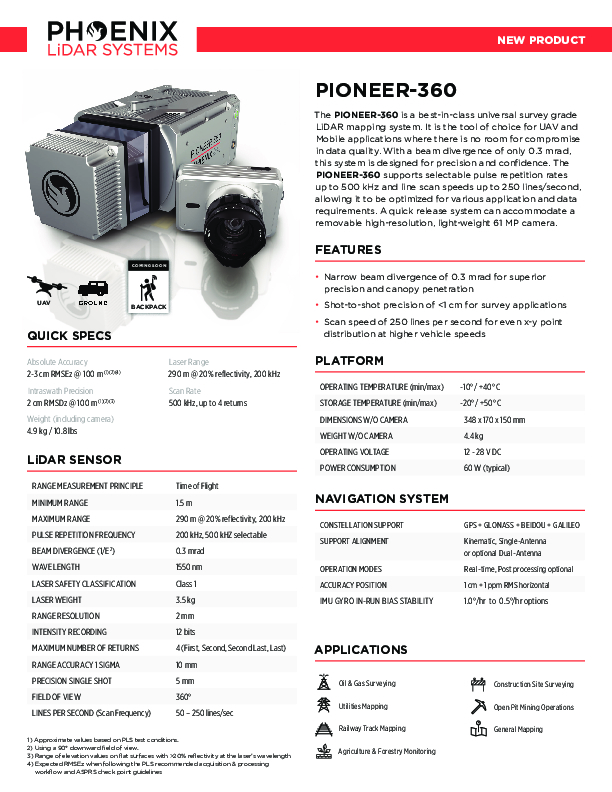
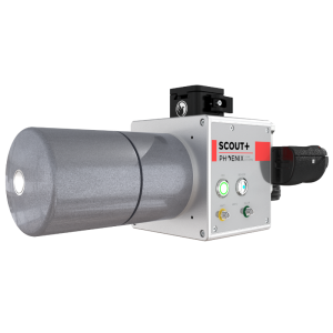
PIONEER-360
Best In-Class Universal Survey Grade LiDAR Mapping System
Narrow beam divergence of 0.3 mrad for superior precision and canopy penetration.
Phoenix LiDAR Systems
Austin, US
Description
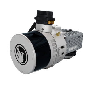
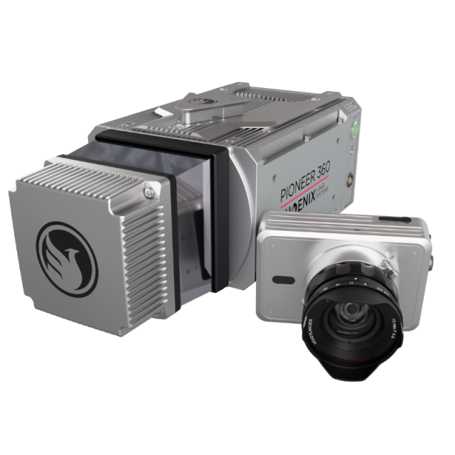
The PIONEER-360 is a best-in-class universal survey grade LiDAR mapping system. It is the tool of choice for UAV and Mobile applications where there is no room for compromise in data quality. With a beam divergence of only 0.3 mrad, this system is designed for precision and confidence. The PIONEER-360 supports selectable pulse repetition rates up to 500 kHz and line scan speeds up to 250 lines/second, allowing it to be optimized for various application and data requirements. A quick release system can accommodate a removable high-resolution, light-weight 61 MP camera.
Features:
-
Narrow beam divergence of 0.3 mrad for superior precision and canopy penetration
-
Shot-to-shot precision of <1 cm for survey applications
-
Scan speed of 250 lines per second for even x-y point distribution at higher vehicle speeds
Quick Specs:
-
Absolute Accuracy = 2-3 cm RMSEz @ 100 m
-
Intraswath Precision = 2 cm RMSDz @ 100 m
-
Weight = 4.9 kg / 10.8 lbs
-
Dimensions = 348 x 170 x 150 mm
-
Pulse Rate = 500 kHz, up to 4 returns
-
Laser Range = 290 m @ 20% reflectivity, 200 kHz
Specifications
-
Application
-
Main applications
Oil & gas, Utilities mapping, railway track, agriculture and forestry monitoring, construction site surveying, open pit mining operations, general mapping
Training, maintanence and support
Provided by Phoenix LiDAR Systems
Distinguishable features
Price point and capabilities between the MiniRANGER-3 LITE and the RANGER-LR LITE
-
Measurement Characteristics
-
Scanning method
Time of Flight
Range accuracy [mm]
10
Scanning Speed [measurements p second]
500
multiple pulses in air
Y
Min. pulse frequency [Hz]
200,000
Max. pulse frequency [Hz]
500,000
Max. field of view [degrees]
360
Max. number of recorded echoes per pulse
4
Recording of intensity of return signal [bits]
12
-
Physical Properties
-
Height [cm]
17
Length [cm]
34.8
Width [cm]
15
Weight [kg]
4.4
Water and dust proof
IP67
-
Laser Pulse Characteristics
-
Laser Class
Class 1
Wavelength [nm]
1550
Beam divergence [mrad]
0.3
Min. range of laser pulse [m]
1.5
Max. range of laser pulse [m]
490
-
Power Supply
-
Power consumption
60 W
Power requirements
12-28V DC
-
Positioning System
-
Number of GNSS positioning sensors
1
Type of GNSS positioning sensors
GPS+GLONASS+BEIDOU+GALILEO
Typical positioning accuracy [cm]
1
Heading, Pitch and Role internally captured
Y
Type of INS or IMU
Various
Gyroscopes Bias In-Run stability [deg p hr]
1.0°/hr to 0.5°/hr options
-
Operation Characteristics
-
Camera included
Optional
Mounting
UAV, GROUD VEHICLE, BACKPACK
Requirements for compatible UAVs
Heavy Lift
Camera specifications
Various
Control and user interface
Phoenix LiDAR System's SpatialExplorer
-
Data and Software
-
Type of storage
flash card
-
General
-
Year of last update
2022
Year of introduction
2022
Documents
Brochure
pls-pioneer-360-spec-sheet.pdf
1.33 MB


