
Orbit 3DM Content Manager
Software to Capture, Model, Share 3D Mapping Content
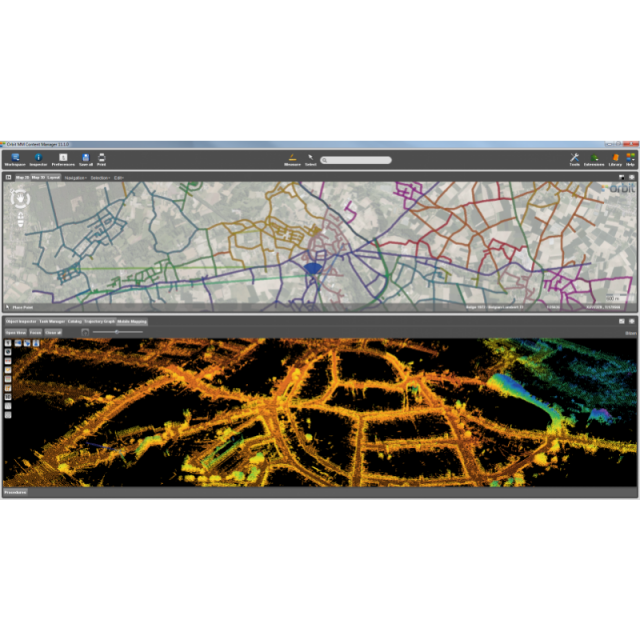
Manage and optimize your 3D mapping data after capture using the powerful 3DM Content Manager. Auto produce & update assets faster and richer than ever before based on the 3DM Feature Extraction portfolio. Supports all hardware systems, all reality capture methods.
Orbit GT
Lokeren, BE
Description
Manage and optimize your 3D mapping data after capture using the powerful 3DM Content Manager. Auto produce & update assets faster and richer than ever before based on the 3DM Feature Extraction portfolio. Install the 3DM Publisher on-premises or activate your profile on 3dmapping.cloud to share 3D mapping projects over the internet, embed in corporate software, or to make them available via mobile devices.
Supports all hardware systems, all reality capture methods : mobile, drone, terrestrial, aerial oblique, indoor, ...
Specifications
-
Hardware/software requirements
-
RAM [GB]
8
HD [GB]
8
Use of GPU
Y
Processor
["64-bit"]
Stereo Display
Y
List software environment, e.g. Microstation
stand-alone
Stand-alone
Yes
-
Other
-
Support
Y
Training
Y
Typical applications
Mobile Mapping (Indoor & Outdoor), Drone/UAV Mapping, Aerial Oblique & LiDAR, TLS
Distinguishing features
Independent to hardware, Unlmimited data size, organize & manage, catalog & archive, improve your data by pointcloud cleaning, instant trajectory adjustment using gcp constraints
-
Files and Registering
-
Geo-referencing
Y
Automatic Target Detection
N
Stitching multiple scans
Y
-
Pre-processing and Automatic Filtering
-
Image matching facilities
Y
Frequency domain decoding for data reduction
Y
Removal of individual outliers
Y
Removal of vegetation
Y
Removal of buildings
Y
Bare ground DEM generation
Y
-
Manual Measurements
-
3D Coordinates extraction
Y
Length and Height
Y
Angle
Y
Distance
Y
Area
Y
Volume
Y
-
Interoperability
-
CAD software
Y
Hydrological software
No
Assigning colour from imagery to points
N
Image overlay on TIN
Y
Integration with other data types
Y
-
General
-
Year of last update
2019
Year of initial introduction
2012
Modules
organize & manage, catalog & archive, improve your data by pointcloud cleaning, instant trajectory adjustment using gcp constraints and much more.
Source of Point Clouds
Airborne Lidar, Indoor TLS, Outdoor TLS, Photogrammetric, Radar
Supported Systems
Hardware independent. Supports all hardware vendor systems and all reality capture techniques.
-
Analysis
-
Line of sight
N
Aspect and slope
Y
Individual tree heights
Y
Simulation facilities
N
Time series analysis
N
-
Automatically Generated Products
-
Regular Grid DEMs
Y
Cross sections
Y
TIN
Y
Contour Lines
Y
Break lines
Y
Boundary detection of solids
Y
Building footprints
Y
Building roofs
Y
3D City modelling
Y
-
Solid Modelling
-
Lines
N
Planes
N
Cubes
N
Spheres
N
Cylinders
N
NURBS
N
Industrial features
N
Earth surface features
N
-
Visualisation and Editing
-
Zoom, pan and rotate
Y
Fly-throughs
Y
Adding Points
Y
Removing Points
Y
Point Reduction
Y
Documents
Brochure
brochures-fact-sheets


