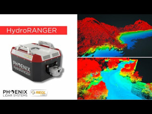
HydroRANGER
The Ultimate Shore-Monitoring System
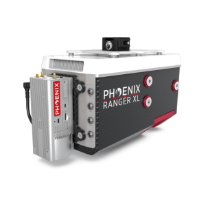
The HydroRANGER is an evolution of mapping technology. This airborne topo-bathymetric (ATB) system provides dual purpose topographic and bathymetric measurements for full scene mapping of shoreline systems. The HydroRANGER uses a green light laser (532 nm) with online waveform processing for topographic, water surface and subsurface target mapping.
Phoenix LiDAR Systems
Austin, US
Description
The HydroRANGER is an evolution of mapping technology. This Airborne Topo-Bathymetric (ATB) system provides dual purpose topographic and bathymetric measurements for full scene mapping of shoreline systems. Utilizing a visible green spectrum laser with an elliptical scan pattern and measurement rates up to 200 kHz, the HydroRANGER provides a combination of high spatial resolution and spatial accuracy. Capable of reaching beyond 2 Secchi depths, this is the ideal solution for mapping land-water interface environments along rivers, reservoirs, oceans and more!
Features:
-
Green light laser (532 nm) with online waveform processing for topographic, water surface and subsurface target mapping.
-
Elliptical scan pattern provides a +/- 20-degree horizontal FOV for low angle of incident measurements.
-
High quality 24 MP camera enables RGB colourization and orthophotography
-
Configurable beam divergence and receiver FOV for low AGL missions.
Quick Specs:
-
Water Depth Penetration = 20 mm
-
Intraswath Precision = 4 cm RMSDz @ 100m AGL
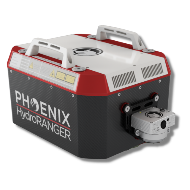
-
Weight = 13 kg / 28.7 lbs approx.
-
Dimensions = 432 x 337 x 202 mm
-
Pulse Rate = 200,000 shots/second, up to 15 returns
Applications:
-
Shoreline Digitization
-
Erosion Control
-
River System Mapping
-
Hydrographic Surveying
-
Engineering
-
Hazard Mitigation
Specifications
-
Application
-
Main applications
Shoreline Digitization, Erosion Control, River System Mapping, Hydrographic Surveying, Engineering, Hazard Mitigation
Training, maintanence and support
1 year warranty on defective hardware or software issues. Training and support can be included with purchase.
-
Measurement Characteristics
-
Range accuracy [mm]
20
Scanning Speed [measurements p second]
200000
Max. field of view [degrees]
40
Max. number of recorded echoes per pulse
15
Scanning method
rotating scan mirror
multiple pulses in air
N
Min. pulse frequency [Hz]
500
Max. pulse frequency [Hz]
200000
Recording of intensity of return signal [bits]
16
-
Physical Properties
-
Height [cm]
20.2
Length [cm]
43.4
Width [cm]
33.4
Weight [kg]
13
Water and dust proof
IP64
-
Laser Pulse Characteristics
-
Wavelength [nm]
532
Min. range of laser pulse [m]
20
Laser Class
Class 3B
-
Power Supply
-
Power consumption
110W
Power requirements
14-28
Type of battery
6S
Operation time on single battery [minutes]
30
-
Positioning System
-
Number of GNSS positioning sensors
1
Type of GNSS positioning sensors
GNSS unit that supports mutli-band signal tracking for all constelations, dual antenna functionality, and up to 100 Hz data rate.
Typical positioning accuracy [cm]
1
Heading, Pitch and Role internally captured
Y
Type of INS or IMU
MEMs IMU with 400 Hz data rate
Gyroscopes Bias In-Run stability [deg p hr]
0.001
-
Operation Characteristics
-
Mounting
The HydroRANGER is designed for mounting on a wide variety of rotorcraft. Combine the power of the HydroRANGER system with our industry leading MissionGuidance software to confidently and accurately execute manned data acquisition missions.
Camera included
Optional
Requirements for compatible UAVs
Phoenix Dovetail quick release
Camera specifications
Depends on camera
Control and user interface
PC software interface capable of displaying real time, georeferenced returns via 5.8 GHz WiFi connection, or a more simplified push-button interface.
-
Data and Software
-
Type of storage
flash card
Max. storage space [mb]
1000000
Included software
Includes software for point cloud creation and data acquisition - trajectory processing software can also be purchased.
-
General
-
Year of last update
2022
Year of introduction
2022
Documents
Other documents
-
HydroRANGER Spec Sheet314.66 KB
Videos


