OPSIA integrates the Ekinox INS in its MBES and MMS solution
The increasing demand for high-resolution 3D bathymetric surveys at ever-increasing depths requires constant innovation from industry stakeholders. With this arises one major challenge: the recalculation between the terrestrial and bathymetric 3D models. OPSIA, a French engineering office specialized in all kinds of surveys, decided to take on the challenge and to solve this problem with a unique solution: combining a multi-beam echo sounder and terrestrial laser scanner.
Combining a MBES with a Terrestrial Laser Scanner
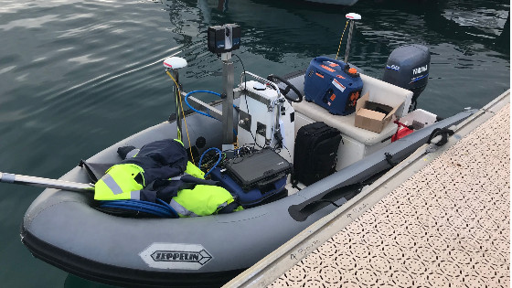
The project consists in combining two different systems which are the MBES (Multi-Beam Echo Sounder) and a terrestrial laser scanner, both used with an Inertial Navigation System (INS). The project was created with the idea of using different devices that the company already had (MBES, laser scanner, INS) and combine them to obtain a combined solution of MBES system and MMS (Mobile Mapping System).
The Solution:
- The Teledyne Reson T20-P full-option multibeam echo sounder
- The FOCUS S150, a terrestrial laser scanner from Faro used as a Mobile Mapping System (MMS)
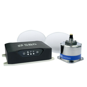
- The Ekinox-U INS from SBG Systems (IMU connected to a SplitBox GNSS now replaced by the Navsight Marine Solution) for both systems synchronization, motion compensation and data georeferencing.

MMS and MBES Synchronization
- The Multi-Beam Echo Sounder system
The Inertial Navigation System is used and integrated as recommended by Teledyne Reson, that is to say by inter-connecting the Portable Sonar Processor, the MBES, and the INS. All devices are synchronized by using a constant PPS signal.
- The Mobile Mapping System
The MMS is combined with the INS thanks to the use of a unique PPS signal, sent through one of the serial ports available on the Splitbox, to start recording laser scanner data and another one to stop recording data. Thanks to the record of the “Event Marker” corresponding to the first PPS signal, the synchronization in time is possible between INS data and laser scanner data.

The Ekinox INS is in the center of the whole system. The MBES is connected to the SplitBox, which allows communication with the IMU and GNSS. The laser scanner is connected to the Splitbox to retrieve the timestamp of each rotation of the laser scanner mirror. Thanks to this and the use of another little electrical component (Arduino NANO), both devices are synchronized in time.
Results and Insights
The results of the Mobile Mapping System are pretty good. While OPSIA did not have sufficient time to evaluate the precision of the system for now, the trajectory given by the INS system seems to be good, and the point cloud obtained by combining the laser scanner and the INS system seems to be good as well. The Ekinox-U matched with the use of the laser scanner.
A big part of the project is done! The next step is to try to combine the MMS with the MBES, which seems to be a formality.
The results should be like the following seawall:


All Photos credit: OPSIA
Do you have questions about this case study?
Get in touch with SBG Systems, and they would be happy to answer any questions you have about pricing, suitability, availability, specs, etc.
Related products


![Do-Giant-Tortoises-Make-Good-Neighbors-1[1].jpg](https://cdn.geo-matching.com/vRMO2Edp.jpg?w=320&s=a6108b2726133ff723670b57bc54c812)


