Next level underwater archeology with underwater tracking and navigation systems
The Underwater GPS (UGPS) G2 tracking system has allowed this customer to compete for commercial projects while supporting their passion for archaeology. Discovering affordable, lightweight, and compatible high-tech equipment for accurate positioning encouraged Bartek and Paweł to pursue making a living out of their passion for underwater archaeology.
Archaeological diving services using affordable and high-tech equipment
“There is no way we can become a viable company by only offering archaeological diving services”.
This is what ArchCom Services in Gdynia, Poland, thought to themselves when they first decided to launch their company. Supplementing their passion for archaeology with commercial diving seemed like the strategically right decision in the company's early days. One of the main challenges was making the business case to purchase additional equipment add up. This is something Bartek and Paweł, the founders of ArchCom, got to experience when they were acquiring their first underwater tracking and navigation system.
Marine technology-based products use state-of-the-art materials and, of course, typically a price tag to go with such advanced equipment. The typical non-commercial applications for these kinds of products have historically been as part of bigger, government or university-backed projects. Projects with vast scientific or monetary value, where investing in high-tech and high-value products has been considered a given. This is great for high-margin investments; but not so great for specialized, streamlined projects such as those ArchCom typically manage.
Hence, the feeling of relief and joy was big when Bartek and Paweł discovered a) our products, b) the price tag of our products and last but not least, c) the performance and capability of Water Linked's products. Finding Water Linked couldn’t have come at a better time during their search for ways to upgrade their approach to subsea operations.
The requirements
Being a company whose bread and butter is providing diving services, Paweł and Bartek had a clear list of requirements for the technology they needed:
- Budget levels were proportional to the company’s young age and, at that time, uncertain customer prospects in underwater archaeology. Hence, the underwater tracking system had to be reasonably priced.
- Accuracy and performance are crucial elements when tracking human divers. More so when the divers conduct archaeological research on invaluable objects on the seabed.
- Portability was an important aspect. Since projects were carried out from a variety of vessels, small and large, the system had to be fully portable.
- The product had to be user-friendly. ArchCom wanted the ability to integrate, maintain and operate its equipment without the need for third parties.
- Physical compatibility with the diver equipment; ensuring that the size of the locator component would not impair the diver’s manoeuvrability was crucial.
- Technical compatibility in terms of API compatibility was a must-have. All positioning data had to be transferable to ArchCom’s third-party map solution: QGIS.
The right underwater positioning system for archeology
Having weighed up all the possible solution providers against their requirements, the choice of underwater positioning system landed on the Water Linked Underwater GPS (UGPS) Explorer Kit, superseded now by the UGPS G2 system. The system’s reasonable price, tailorable and portable nature, and performance capability made it the best choice. To provide ArchCom with accurate positioning data, the D1 Locator was chosen due to its flexible mounting capabilities. And most importantly, it all had to fit in with the technical and mechanical setup of their operations:
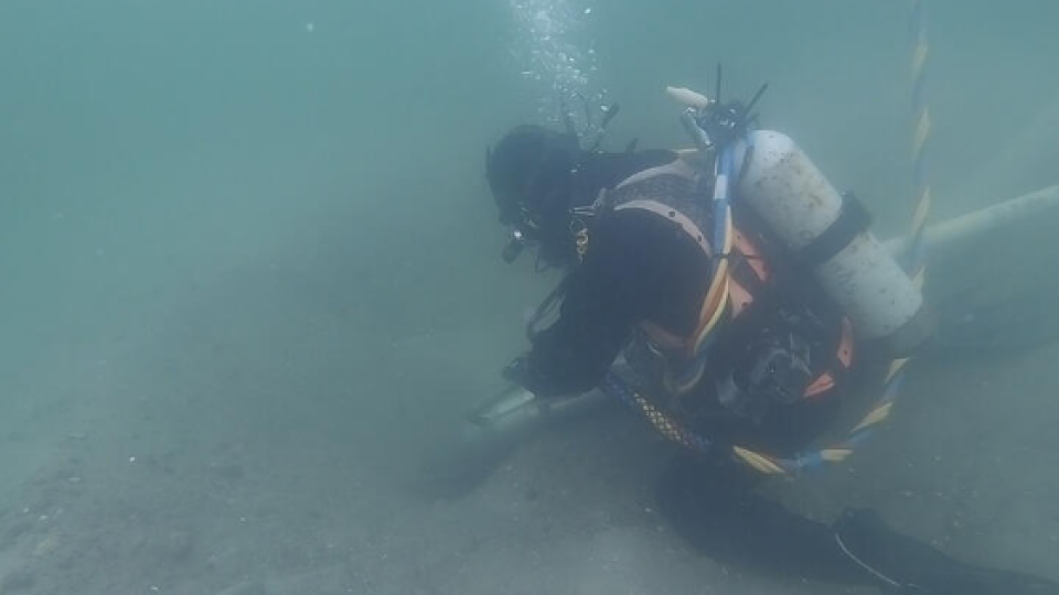
When out on projects, ArchCom’s diving crew consists of at least four people, excluding the vessel crew. The diver supervisor, who is responsible for tracking, depth as well as air and communication, has everything to do with the diver’s health and safety alongside the tracking and logging of the research. Secondly, you have the tender, whose job is to help the supervisor and monitor the umbilical tether. Then there are two divers., First and foremost, the main diver, whose job is to carry out the task underwater - identifying and documenting finds, extracting objects, replacing objects or anything in between. As a default safety measure, there is also a backup diver. This diver is always standing by, ready to dive in to support the main diver. The elaborate team structure is just one of the many things that separate ArchCom, a certified commercial diving company, from sports divers; their safety and quality processes.
The convenient size of the D1 locator allows it to be mounted on the top of the diver’s back. This keeps the locator centred on the diver’s body, making the positioning data as accurate as possible.
To supply the diver with light, breathing gas, a live camera connection as well as direct communication, ArchCom uses an umbilical tether. This makes for convenient integration of the signal and power cable for the Water Linked D1 locator. In ArchCom’s case, the cables for the D1 locator are the same length as the umbilical cord, meaning they have accurate tracking for as deep as the diver can go.
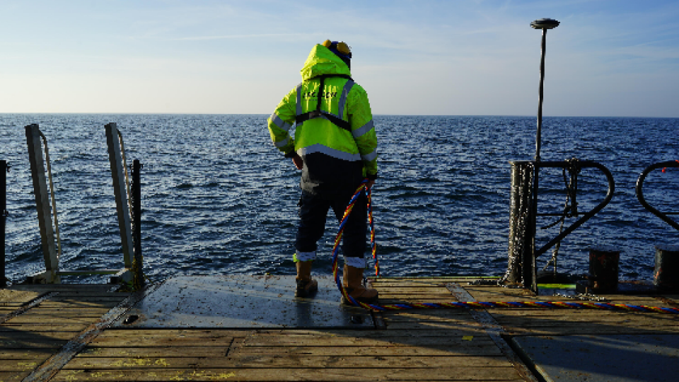
For triangulation, a 4-point custom baseline setup is used. “The custom baseline setup allows you to create a custom triangulation baseline; however, we might acquire an antenna setup, too. It is portability and easy calibration could come in handy,” Paweł said when asked whether they have considered adding the antenna to their setup.
The result
Adding advanced underwater positioning to their tech stack was a necessity for ArchCom to deliver their services:
“Being able to provide highly accurate positioning data from our research is crucial” Bartek replies when asked about the value of the increased availability of underwater technology
Historical accuracy or accurate history?
Since acquiring the system upon its release, the system has proven useful in a range of projects.
Not long ago, ArchCom were hired to support with a watching brief in relation to a commercial pipe laying project where their main task was to make sure cultural heritage was not affected throughout the construction process. It was during this project they identified an anomality on the seabed. The anomality, proving to be a large collection of timber from two shipwrecks, could not be avoided; the path of the pipe could not be diverted. Thus, ArchCom’s watching brief had turned into an active task: they had to temporarily remove the remainders of these shipwrecks from the seabed, supervise the installation of the pipes, and then dispose of the timber in predefined underwater trenches. Time was of course of the essence - the overhanging piping project was on a tight deadline.
Working with a team of highly experienced professionals, ArchCom found a solution on how to get it done. -A solution where the Water Linked Underwater GPS Explorer Kit was invaluable.
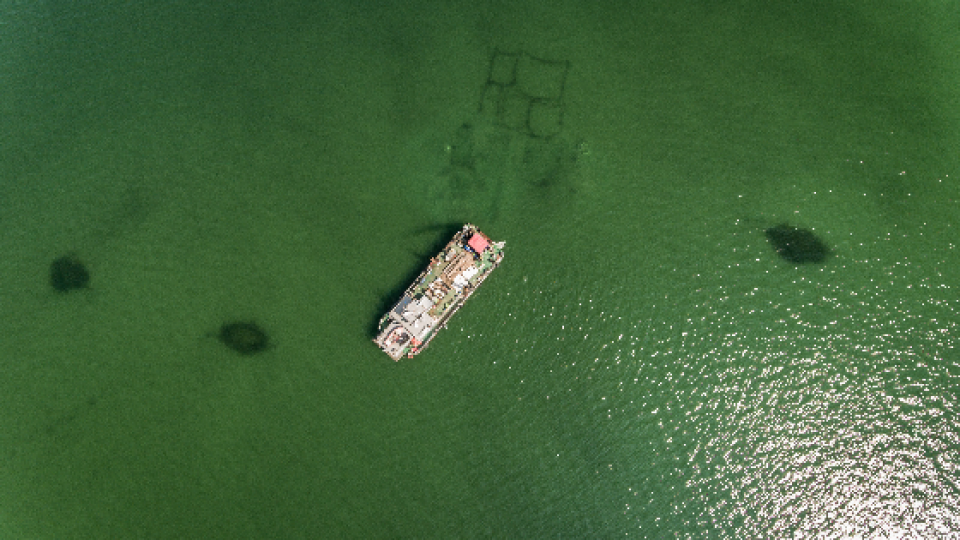
Before starting any kind of object extraction, mapping the location of every single object was required. The position mapping was done with a
combination of the Explorer Kit as well as traditional GPS receivers mounted on poles above water.
Using a special kind of rope, the shipwreck’s position was recreated visually as seen in the drone photo. What cannot be seen in the photo are all the positioning points which provide precise GPS instructions as to where each recovered object should be replaced at the end of the project.
For these kinds of projects where the main goal is to observe and identify anomalies on the seabed, the Water Linked UGPS system has proven invaluable to ArchCom. Using the Water Linked positioning system, they can guide the diver directly to the pre-mapped locations without time-consuming searches. This also works the other way around; when the diver is searching for anomalies and structures whose location is unknown. In these situations, the dive supervisor can not only mark the position of new discoveries but also track previous diver movement to exclude areas that have already been searched.
Creating photogrammetric, underwater hybrid maps
Another core service ArchCom offer is creating hybrid maps using underwater photogrammetry and advanced mapping technology. The Explorer Kit helps enable accurate mapping and tracking according to the photogrammetry models.
Paweł expresses his fondness for the API integration the UGPS offers, saying “Although we did not handle the API integration ourselves, its tailorability was one of the reasons we chose Water Linked.”. ArchCom don’t actually use the provided WL UGPS Graphical User Interface (GUI), but rather they map all the positioning data into their third party mapping solution, QGIS. “Integrating the UGPS with QGIS allows us to dynamically transfer the mapping data onto the photogrammetry models. This way we can also much more accurately navigate the diver around these fragile pieces of history, from above the surface”.
“We will always be archaeologists first...”
When asked whether the filled-up agenda, stretching far ahead in time, meant they will solely focus on archaeological diving, the response is mutual from both:
“We will always be archaeologists firsts, so obviously archaeological projects will be most attractive to us. But for now, we also consider projects that are not strictly archaeological!” Paweł says with a smile on his face.
With the help of affordable, innovative, and advanced underwater technology, ArchCom can keep honing its product offering within the archaeological sphere allowing them to use advanced technology in this area thanks to the needs of the commercial projects.
We at Water Linked are extremely pleased to see how ArchCom have managed to tailor our equipment to fit their needs exactly and look forward to following their journey ahead! And who knows, maybe we have some soon-to-come product launches that would make another great addition in the field of underwater archaeology?
About Water Linked
Water Linked is revolutionizing underwater acoustics with cutting-edge technology. Founded in Trondheim in 2013, the company aims to be at the forefront of high-end subsea communication and positioning systems. Using innovative R&D projects, Water Linked brings the latest underwater acoustic systems to global maritime markets, paving the way for the next generation of underwater exploration and discovery.
Do you have questions about this case study?
Get in touch with Water Linked, and they would be happy to answer any questions you have about pricing, suitability, availability, specs, etc.
Related products


![Do-Giant-Tortoises-Make-Good-Neighbors-1[1].jpg](https://cdn.geo-matching.com/vRMO2Edp.jpg?w=320&s=a6108b2726133ff723670b57bc54c812)


