Maximum Efficiency in Wartime Aerial Photograph Interpretation
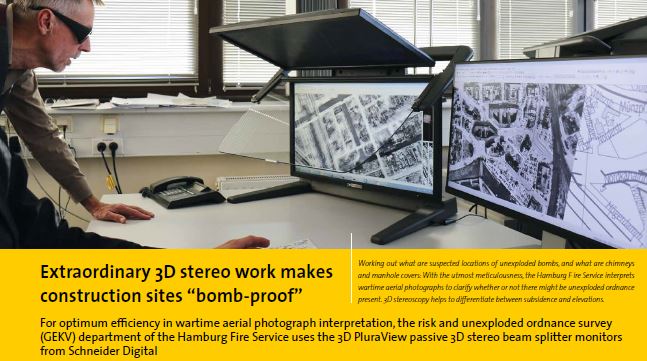
For optimum efficiency in wartime aerial photograph interpretation, the risk and unexploded ordnance survey (GEKV) department of the Hamburg Fire Service uses the 3D PluraView passive 3D stereo beam splitter monitors from Schneider Digital.
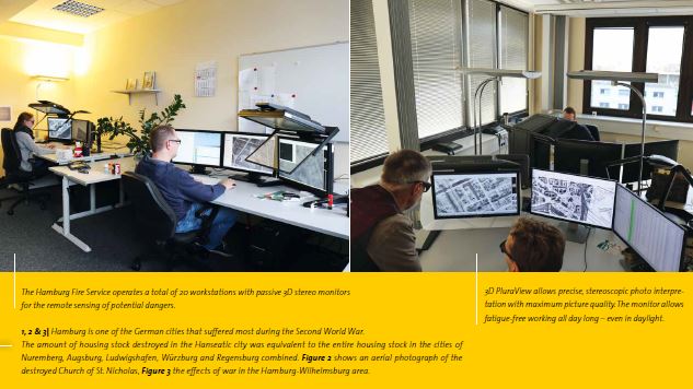
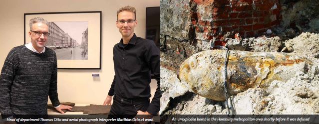
Hamburg is one of the German cities that suffered most during the Second World War. The volume of homes destroyed in the Hanseatic city was equivalent to the entire volume of homes in the cities of Nuremberg, Augsburg, Ludwigshafen, Würzburg and Regensburg combined. Between 18th May 1940 and 17th April 1945, a total of 213 air raids were flown against Hamburg and a total of some 107,000 high-explosive bombs, 3 million incendiary bombs and 300,000 phosphorous fire-bombs were dropped – resulting in significant “collateral damage” because approximately 70 per cent of the city’s buildings were destroyed. All the explosive ordnance of the time rained down from the skies. The largest bunker-busting bombs weighed 12,000 pounds, with the smallest incendiary bombs weighing 4 pounds. And it was all documented. Over no other city in the world were so many aerial photographs taken during the war. At the present time there are 30,000 known photographs of Hamburg. “Another advantage is that there was hardly any ground combat in Hamburg. Quite unlike in Cologne or Berlin. This means we can assume that the effects of war came solely from the air raids and not from artillery bombardment for example”, explains Thomas Otto, head of the Hamburg Fire Service’s risk and unexploded ordnance survey (GEKV) department.
The GEKV department is responsible for categorising construction sites within the municipal area in terms of their potential risk for the presence of ordnance. The categorisation is based on the evaluation of historical aerial photographs from both Allied and German armed forces sources from the period 1940 to 1946. Where available, secondary sources such as logbooks or other written records are used to further ensure a correct decision. Before any construction work begins in Hamburg, it is necessary to precisely review whether still, unrecovered unexploded bombs might still be lying dormant on the intended construction site.
“With stereoscopy we’re embarking on a “trip through time”. Stereo work with the 3D PluraView monitor gives us a vivid, spatial, 3D impression of the situation on site 70 years ago”
Precise stereoscopic aerial photograph interpretation
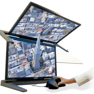
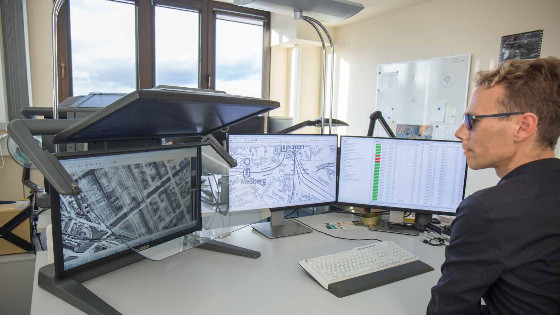
The wartime aerial photographs are stereoscopically interpreted at a total of 20 workstations that are equipped with high-end stereo displays of the type 3D PluraView from Schneider Digitale.K. (Miesbach). The 3D PluraView monitor works with the enhanced passive 3D stereo and display technology of the PLANAR beam splitter series that was retired years ago. Innovative, reliable technology forms the basis for the precise stereoscopic representation of the highest quality. For this, the 3D PluraView beam splitter technology delivers full monitor resolution of up to 4K in brilliant brightness thanks to two displays. “A very important element of this is a spatial 3D stereo representation because that lets
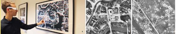
us see whether a black spot on the image is subsidence or an elevation: A subsidence can be an indication of an unexploded bomb that entered the ground but did not detonate”, explains aerial photograph interpreter Matthias Otto, citing another example in which the overlapping of two photos helps to decipher a suspected case: “Stereoscopy makes it easier to see whether or not the intermediate floors were present in damaged buildings. If they were still there, that part of the site is no longer under suspicion, but if none of the floors remained it most definitely is.” It is impressive to see the Sherlock Holmes-like meticulousness and sensitivity employed by the team on this “trip through time” and how the 3D PluraView Display technology from Schneider Digital at the same time helps to track down dangerous bombs and left-overs from the war. Matthias Otto sums it up by explaining that “stereoscopy with 3D PluraView monitor gives us a vivid, spatial, even quasi-virtual impression of the situation on-site 70 years ago”.
A prerequisite for an interpretation of this type is that two photographs of the same scene taken at different times are available. “A continuous series of images were taken in most cases, with the camera being triggered at fixed intervals. The aerial photograph interpreter goes on to explain that “the altitude at which the reconnaissance planes flew was not constant, resulting in distortions within the aerial photographs. Suitable measures enable these distortions to be almost eliminated, so that interpretation with very accurate positioning is nevertheless possible”. “When a dark spot can only be seen on one photo it’s obvious that this is an artefact, or conversely it may be the case that a black dot on the mono image reveals, for example, the presence of just an advertising column in the stereo image.” The main interpretation software used by the Hamburg Fire Service is ERDAS IMAGINE from Hexagon Geospatial and ArcGIS von Esri.
Technological progress in “seven-league boots”
“The only option in the past for those who needed professional, high-resolution 3D stereo visualisation in geoinformatics was the PLANAR beam splitter monitor series. The specialist company for 3D stereo, virtual reality (VR/AR), 4K and high-end hardware Schneider Digital based in the town of Miesbach in Upper Bavaria has invested a lot in the enhancement of beam splitter technology. This has resulted in an innovative, completely new generation of 3D monitors called
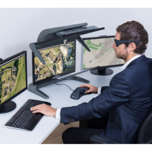
3D PluraView, which in its turn is now recognised as the technical benchmark in the passive 3D stereo field for the entire industry. Unlike active 3D monitors, 3D PluraView is completely flickering free, which makes it ideally suited to continuous professional use that’s gentle on the eyes throughout the working day - even under daylight conditions. Head of department Thomas Otto asserts that “working in darkened rooms like in the 1990s is a thing of the past since the arrival of 3D PluraViews”. The market is delighted with the razor-sharp picture quality of up to 4K/UHD per eye and the depiction of the finest details on the 27" or 28" screens that 3D PluraView Display provides.
The units are certified for all common 3D stereo software applications in GIS, photogrammetry and mapping, not just from the already mentioned system suppliers Hexagon (Geomedia) and Esri (ArcGIS) but also from Trimble (Match-AT/DTMaster/UASMaster), Erdas (IMAGINE Photogammetie), TerraSolid (TerraStereo), Rhino (SARL RhinoTerrain), PurView (PurVIEW) or Leica (LeicaGeosystems). The Hamburg Fire Service was the first (major) customer for the 3D PluraView generation of monitors. Schneider Digital unveiled it for the first time at the international GIS trade fair Intergeo in October 2016, and the first units were delivered to Hamburg just one month later.
Compared with the Planar beam splitter, there were a number of improvements besides display size, brightness and resolution. For example, the monitor is now of a much more sturdy design – top “Made in Germany” quality – with the result that there is practically no vibration when it is touched. Also consigned to the past are the tapered mirror edges of its predecessor, which could hinder the observer standing to the side in trying to evaluate certain sections of the image, as Matthias Otto explains. He also points to another very convincing argument: “The 3D PluraView monitor enables fatigue-free working all day long – even in daylight and without the need to darken the rooms.”
Unexploded bombs can sink into the ground and vanish
The Hamburg metropolitan area is 755 km2 in size. Every discovered impact point is precisely measured and allowance is made for the unexploded bomb’s drift. In the beginning, it was assumed that the maximum difference between the point of entry into the ground surface and the final location would be between 4 and 5 m. “But today we know that it could be as much as 9 m. Last year, three unexploded bombs were found in places where during the 1990s searches were made for them in a radius of 5 m around the impact point and nothing was found”, says the department’s head Thomas Otto. Around 11,000 reports of unexploded bombs are known to date back to the outbreak of the war, some of which were dealt with during the war. The use of wartime reports gives rise to particular challenges because there was no comprehensive documentation of bomb disposal operations before the GEKV department was established. As long
ago as 1990, Thomas Otto began to construct for the Hamburg Fire Service a systematic evaluation and databases of aerial photographs originating from both primary and secondary sources. He acquired the necessary extensive knowledge himself and later set up a staff training program because there simply isn’t any professional training for detecting hazards using wartime aerial photographs.
3D PluraView as a benchmark for 3D stereoscopy
Since 2004, all analysis of wartime aerial photographs by the Hamburg Fire Service has been done digitally. From this point onwards, the software was available for adding figurative marks for example, and for enabling work with approximate values for focal distances and altitudes. Even then, NewVision systems with tube monitors were being obtained from Schneider Digital. A system with shutter glasses had previously been used, “which put a great strain on the eyes”. The reflection from the monitors was so great that although you could see yourself very clearly, you could only recognise the aerial images moderately”, recalls Thomas Otto with a grin. The defining moment of the first passive 3D stereo PLANAR monitor systems with beam splitter technology came in 2009. They raised the system support in remote sensing to a new level.
These 20 stereo aerial photograph interpretation workstations are now gradually being equipped with 3D-PluraView technology to replace the PLANAR displays. How did the way of working change in the wake of digitisation? Thomas Otto makes it clear from the start: “Due to the number of applications to be dealt with, it was clear that we’d have to employ new staff. Whereas there were just over 200 applications prior to digitisation in 2004, today the number is around 11,000 per year – due also to the amended Munitions Ordinance.” But why so many applications for investigation by the risk and unexploded ordnance survey department? After all, the war has been history for over 70 years. In Hamburg, a survey must be conducted before and construction work. This requires the site owner or the party wishing to excavate the ground to submit an application to the GEKV department for the purpose of risk investigation / aerial photograph interpretation. Thanks to -among other things - 3D PluraView monitors, the applicant receives a map section of the planned construction site containing the most precise information possible about potential dangers so that these can be investigated at as low a cost as possible.
A private service provider uses this detailed information from the GEKV department to conduct an on-site search if it is suspected that unexploded ordnance might be present. As Thomas Otto affirms, to keep on top of the deluge of orders and to speed up procedures, intensive efforts were made to pull out all the process automation stops. For example, all areas of Hamburg were digitally recorded via a GIS system and the databases were made more professional. Every aerial photograph earmarked for interpretation availability was scanned in with high resolution. For this, it is of the utmost importance to use only raw data, because subsequent image processing or “optimisation using the software” – as was erroneously done in the past by one industrious service provider – can corrupt the information content.
Human intelligence surpasses artificial (AI)
In collaboration with the software provider Esri of Switzerland, the software was developed based on their ImageServer technology in order to achieve the fastest possible image retrieval. Matthias Otto adds that one major advantage of these efforts is that several staff members can now work simultaneously and in parallel on the same image, something that was previously not possible on physical photographs. “That was a big step towards speeding up our procedures.” Artificial intelligence with its possibilities for pattern recognition is currently doing the rounds not only among experts. Aerial photograph interpretation would appear to be a profitable area of application there after all. Thomas Otto waves dismissively: “We’ve tested and examined that very intensively. Pixel-based pattern recognition gets us nowhere because the number of hits in automated image analysis is much too low. Just think: Only a proportion of the bombs that are actually documented in a wartime aerial photograph have been verified! That’s way too uncertain! As supporters of systematic digitisation and automation, even we have to admit defeat here. We trust digitisation and automation only where it makes sense, or more specifically where it benefits obtaining the best and most reliable result. To us, that means Professional GIS software plus 3D PluraView monitors plus a human specialist for professional analysis and the most reliable interpretation.”
The project at a glance
The task
- Remote sensing of construction sites for unexploded ordnance from the Second World War using stereoscopy from primary sources (aerial photographs) and secondary literature
- Achieving the greatest possible level of safety against potential dangers on site
- Professional analysis using 3D GIS software
- Faster photo interpretation processes requests dealt with more quickly
The demands placed on 3D visualisation technology
- Highly detailed stereoscopic 3D representation of aerial photographs from the war
- Optimum ergonomics to allow use over the entire working day
- Aerial photograph interpretation on the screen in daylight conditions
- Small overall depth and projection, sturdy frame
- Plug & Play system without the need for special software or hardware
- The system must be fully compatible with GIS software applications
- Complete workplace solution with monitors provided by the client
The solution - Schneider Digital 3D PluraView
- Screen size / resolution: 27", 2,560 x 1,440 pixels per eye
- 3D display technology: 210 cd/m2 brightness with glasses
- Linear polarisation: 45°/135°
- Beam splitter: semi-transparent reflector
- PC and graphics card: Siemens PCs, NVIDIA Quadro
- Infrastructure: Up to 2 monitors provided by the client used for parallel database applications
Software use
- Analysis: ERDAS IMAGINE (erdas), geospatial (hexagon)
- GIS: ArcGIS (Esri)
- Communication: MS Office Tools
The result
• A shift to 100% remote sensing on the PC: Thanks to high-performance 3D stereoscopy, remote sensing is the only method now used to investigate the suspected presence of ordnance
• Sophisticated beam splitter technology enables GEKV staff to work all day without getting tired
• The entire photo interpretation and job processing workflow is accelerated
• Working in darkened rooms is a thing of the past
• Precise stereoscopic aerial photograph interpretation with 3D-capable GIS software
Portrait
Hamburg Fire Service GEKV department The Hamburg Fire Service risk / unexploded ordnance survey department (known by its German abbreviation GEKV) is responsible for categorising areas within the municipal area in terms of their potential risk for the presence of ordnance. On application, the potential risk in the various sites is determined by way of stereoscopic aerial photograph interpretation using 3D PluraView monitors from Schneider Digital on the basis of historical aerial photographs and is documented in the register of potentially hazardous sites kept by the risk and unexploded ordnance survey department. External companies survey the suspected sites. The basis for this is more than 30,000 digitised aerial photographs from the Second World War from the archives of the Royal Air Force and the U.S. Air Force. Once ordnance has been detected, the find is investigated and then made safe by bomb disposal teams.
Schneider Digital 3D PluraView Monitor - Passive 3D stereo display reference
The 3D PluraView from Schneider Digital is the enhanced successor to the beam splitter range from PLANAR. Innovative, reliable technology forms the basis for precise, accurate stereoscopic photo-interpretation of the highest quality, even in daylight. For this, the 3D PluraView beam splitter technology delivers full monitor resolution of up to 4K/UHD in brilliant brightness and completely fl icker-free thanks to a display for each eye. This enables the user to work comfortably and fatigue-free in all stereo 3D software applications in many different fields, such as GIS / mapping, photogrammetry or 3D city model visualisation.
3D PluraView highlights
• Flicker-free for continuous professional use
• Maximum brightness – suitable for daylight use
• Two housing designs: 22" or 27"/28"
• Full HD resolution, 2.5K or 4K per eye
• Certified for photogrammetry & GIS
• Wide viewing angle for multi-user operation
• Top quality, engineered & made in Germany
The 3D PluraView is the passive 3D stereo system that delivers the maximum level of user satisfaction and user acceptance among all the 3D systems currently on the market. The beam splitter technology has been well established on the market since 2005, and the 4K 10-bit version has established itself as the 3D stereo reference.
Do you have questions about this case study?
Get in touch with Schneider Digital, and they would be happy to answer any questions you have about pricing, suitability, availability, specs, etc.


![Do-Giant-Tortoises-Make-Good-Neighbors-1[1].jpg](https://cdn.geo-matching.com/vRMO2Edp.jpg?w=320&s=a6108b2726133ff723670b57bc54c812)


