


How WASSP Mutlbeam Echosounders are used to Survey Sites for Aquafarming
For this particular situation, Kelp Blue needed to map a number of assigned sites in coastal Namibia to determine suitability for kelp farming, all without experienced hydrographic experts or complex system configurations. Sites required a detailed analysis of bathymetry and seafloor material which could be used to pinpoint the most favourable locations for substrate structures and anchors.
Kelp Blue is a collection of divers, sculptors, sailors, explorers and nature lovers who have the aim to restore the planet to equilibrium, or even to abundance by nurturing the marine ecosystems that help reverse climate change. Inspired by Giant Kelp, we will look to rapidly grow and deliver transformative benefits across markets.
The team currently focuses on cost-effective, long term and environmentally sustainable solutions by growing and managing large-scale Giant Kelp forests. These underwater forests safely lock away vast amounts of Co2 in the ocean forever.
Kelp forests also help sustain healthy marine ecosystems, providing food and shelter for countless species.
Kelp Blue is currently conducting an Environmental Impact Assessment (EIA) and has applied for an operating licence in Namibia. If successful, a pilot scheme will be conducted off the coast of Luderitz, where it will benefit from the constant upwelling of the Benguela Current.
Namibia’s offshore waters offer the perfect conditions for growing kelp. Namibia has a government supportive of the blue economy as well as a strong and capable workforce. Kelp Blue will work with Namibia’s academic institutions to facilitate research and skills development in marine biotechnology, mechanical and marine engineering, research and innovation.
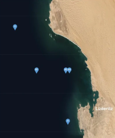
Image 1: Point swhere multibeam data were collected
Collecting Bathymetry and Seafloor Data with Multibeam Sonars
For this particular project, Kelp Blue needed to map a number of assigned sites in coastal Namibia to determine suitability for kelp farming, all without experienced hydrographic experts or complex system configurations. Sites required detailed analysis of bathymetry as well as seafloor material which could be used to pinpoint the most favourable locations for substrate structures and anchors.
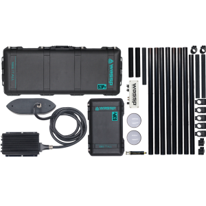
Equipment Requirements
Kelp Blue required a system that was simple enough to use without expert hydrographic survey knowledge, within a short time window. In addition, the system needed to be able to export to 3rd party software in order to do further post-processing and analysis.
The S3i is WASSP’s entry level Survey Multibeam system, and was chosen for this particular project due to its speed and ease of use, reducing setup and testing time. The Multibeam configuration from WASSP was also selected due to its integration capabilities and overall cost effectiveness – and for cost saving was paired with lower cost GPS satellite compass and motion sensor for this project (superior results can be attained with higher grade sensors).
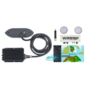
- The S3i setup kit included:
- IP66 DRX Processing Unit
- 90-190kHz Wideband Fairing Transducer
- Satellite Compass
- Motion Sensor
- CDX UI Software
- Survey Interface License
- Backscatter License
- Pelican Carry Cases
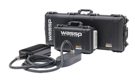
image 2: the WASSP Multibeam Sonar Set
Multibeam Survey Data
Overall scope was to survey 5 assigned sites were near the Namibian coast. Five days survey time was allocated to complete the survey. The sites were of differing depths and distance from the coast.
Pilot Plots
|
Sailing distance |
Water depth |
|
|
Plot A |
20 km |
65m – 85m |
|
Plot B1 |
30 km |
115m – 135m |
|
Plot B2 |
20 km |
50m – 70m |
|
Plot B3 |
20 km |
50m – 70m |
|
Plot C |
50 km |
140m – 160m |
Plot A
Plot B1

Plot B2

Plot B3

Plot C

The Backscatter/Intensity capability of the WASSP S3i was particularly important for collecting the level of data required in order to determine seafloor material composition and ensure the sites selected would allow sufficient anchoring of structures with longterm viability.
Plot B2

Plot B3

Plot C

Multibeam Survey Outcomes
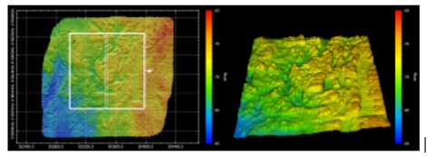
From the information gathered, Kelp Blue was able to successfully select and allocate 2 of the most suitable sites due to bottom bathymetry and material. With the data from the WASSP S3i multibeam it was clear these 2 sites had a flat, sandy bottom making them the best choice for anchoring and substate structures from the 5 allocated sites.
Plot B2 Cross-section
Small (± 35cm) height difference over 300m

Plot B3 Cross-section
Small (± 35cm) height difference over 300m

Other sites were shown to have unsuitable bathymetry or contained materials such as rock or too much gravel.
Kelp Blue were also able to completed the survey in a shorter period than initially planned. Utilising the WASSP Multibeam, the survey for all 5 allocated sites was completed in 1.5 days. This is much faster than the original planned 3-4 days survey time frame, saving the Kelp Blue team valuable time and money.
Note: These surveys were conducted with entry level cost effective sensors, as deemed appropriate for this project. As such, it should be noted that WASSP results could be considerably improved by utilising higher grade WASSP RTK GNSS INS, and incorporating a Sound Velocity Sensor.
Conclusion
The site surveys with the WASSP Multibeam has allowed Kelp Blue to perfectly individualize the right locations for their project and everything was done in a shorter time period than initially planned due to the benefits of Multibeam technology mapping wide areas and speed of WASSP operation. Survey operations were able to be successfully completed without the use of expert hydrographic surveyors, reducing time, expense and improving in-house knowledge of the proposed sites. Plot sites B2 and B3 were identified as the most suitable for installing substrate structures for the kelp growing operations with bottom bathymetry identified as having relatively low water depths, with flat and even sea bottom contours, and uniform sediments.
Do you have questions about this case study?
Get in touch with WASSP Multibeam, and they would be happy to answer any questions you have about pricing, suitability, availability, specs, etc.


![Do-Giant-Tortoises-Make-Good-Neighbors-1[1].jpg](https://cdn.geo-matching.com/vRMO2Edp.jpg?w=320&s=a6108b2726133ff723670b57bc54c812)


