


High Definition Eelgrass Mapping Survey in San Diego With CEESCOPE Singlebeam Echosounder
How the CEE ECHO and CEESCOPE Singlebeam echo sounders can accurately map sub-aquatic vegetation coverage and plant height, demonstrated by an Eelgrass survey conducted in San Diego Bay, a well-known Eelgrass habitat.
The data output of the CEESCOPE and CEE ECHO Singlebeam Echosounders includes digitized soundings and a full water column echo envelope at 20Hz in addition to the boat position obtained from a GPS receiver. The digitized sounding data accurately tracks the bottom along the survey track however when sub aquatic vegetation (SAV) is present, any Singlebeam Echosounder, including the CEE equipment, will not be able to differentiate between the “true” bottom and thick vegetation above. So, the digitized sounding data becomes unreliable. In these circumstances, the highly detailed echo envelope output allows the surveyor to understand exactly where the vegetation is present and adjust soundings accordingly, so the survey accuracy is preserved.
This feature, lacking in basic “black box” sonars, is crucially important in a high-grade Singlebeam Echosounder to maintain accuracy in difficult survey environments. However, the echogram output, coupled with high-quality editing software such as HYPACK not only allows the editing of spurious vegetation signals from the data but it facilitates the active determination of plant height and coverage where these factors are the survey goal and not just an inconvenience. The process of SAV mapping is described here.

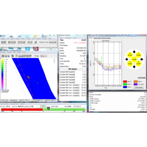
Figure 1: Moderate Eelgrass Density Echogram sample in HYPACK
The Echosounder is first set up with a low detection threshold; in this case, the builtin bottom tracking algorithm will be very sensitive in detecting the first sonar energy return, coincident with the top of any vegetation. Usually, the AUTO bottom tracking mode will work best for the CEESCOPE or CEE ECHO; this will ensure that there is enough available sonar energy to detect the top of the vegetation and penetrate through to the “real” bottom underneath. A test survey line may be run over the vegetation to ensure both the vegetation canopy and “real” bottom is visible on the echogram. Increasing the power output of the Echosounder in MANUAL mode can boost the signal intensity over the AUTO set point if required, usually only when very tall vegetation is present in quite shallow water.
The echogram is viewed in real-time during the survey to ensure that vegetation is being effectively mapped over all parts of the area of interest. Survey data may be recorded on the CEESCOPE or CEE ECHO and simultaneously in HYPACK as normal for a Singlebeam hydrographic survey. A 370m x 275m (1200ft x 900ft) area of San Diego bay was mapped in this manner to illustrate the process. After editing the data for minor surface water column noise, the first data output is simply the digitized soundings. These will represent the top of the vegetation and the “real” bottom where it is not obscured by the SAV above, shown in Figure 2.

Figure 2: TIN Model Output at 5m x 5m Grid Spacing, Upper Surface (with SAV)
Then, the HYPACK digitizer tool in the Singlebeam Editor (SBMax) is used to draw the “real” bottom surface for each survey line. Using Figure 1 as an example, the digitizer trace would simply follow the clearly defined “real” bottom profile at 2.83.6m depth. The data are exported exactly as for the un-modified soundings and the results are shown in Figure 3, below. The process is quite fast owing to the powerful editing functions available in HYPACK. Without SAV, it’s a much clearer picture!

Figure 3: TIN Model Output at 5m x 5m Grid Spacing, Lower Surface (“real” bottom)
These two datasets re-digitized “real” bottom and the original dataset including vegetation may now be overlaid on top of each other to compare the two sounding points. Where there is a difference there is vegetation present, and the size of the difference is the plant height. Easy! HYPACK has a built-in tool to manage this calculation as two TIN model surfaces can be loaded, and the difference may be exported as a separate file in several formats including XYZ. Even easier! The final output is shown in Figure 4, with an Eelgrass coloured scale added.
By using a 5m x 5m grid, the survey results may be converted to a quantitative measure of vegetation extents that may be cross-checked by physical inspection using underwater photographs or divers.

Figure 4: TIN Model Output at 5m x 5m Grid Spacing, Eelgrass height
As the technique uses a Singlebeam Echosounder making point measurements under the survey track, the TIN model calculation interpolates between sounding lines to fill in the entire survey area. It is up to the surveyor to determine the appropriate line spacing to obtain an adequate representation of the vegetation extents for each project. For the example presented here, a line spacing of about 15m was used.
By using HYPACK instead of proprietary vegetation-mapping packages the powerful traditional bathymetry survey capabilities of HYPACK and CEE HydroSystems echo sounders are available for other routine hydrographic surveys where habitat mapping is not a focus.


![Do-Giant-Tortoises-Make-Good-Neighbors-1[1].jpg](https://cdn.geo-matching.com/vRMO2Edp.jpg?w=320&s=a6108b2726133ff723670b57bc54c812)


