


Catching Fire – Aerial Fire Mapping / VarioCAM® HD head for Airborne Thermography in New Zealand
Wildfires are a permanent threat to several regions around the world, and global climate change is adding to the number and severity of these events. Fighting them is a huge challenge, strong winds, heat and inaccessibility make it even more difficult and dangerous for those who risk their lives to protect others. One approach to tackle wildfires is the usage of airborne fire mapping. Highland Helicopters is a service company that added this task to their portfolio, as wildfires on New Zealand´s South Island happened right at their front door. On board is the VarioCAM® HD head 800 from InfraTec.
The public perception of devastating wildfires in the Northern Hemisphere is typically allocated to disastrous events happening in California or the Mediterranean region and in the Southern Hemisphere in Australia. Some regions in neighbouring New Zealand, however, are suffering from burning forests, fields and bushes as well.
Fire mapping from a helicopter offers a unique elevated perspective on remote fires to those who have to direct firefighting ground activities. The (1,024 × 768) pixels LWIR thermal camera VarioCAM® HD can detect through smoke and dust that block video camera views in the visual spectral range – this is a great benefit for on-site situational awareness. When this camera is radiometrically calibrated it also creates the opportunity to indicate actual fire and ground temperatures. Additional support for active firefighting can be given to ground staff and waterbombing aircraft, as VarioCAM® HD capabilities clearly traces the water ground tracks to assist the involved pilots.
The sparse population of New Zealand´s South Island forces local firefighters to bridge large distances when a wildfire has started somewhere in the rural landscape of the Canterbury or Otago districts. When Paul Williams started his helicopter service business in Dunedin in 2016 his focus was set to agricultural and commercial flights. As bushfires lit up in 2018 and 2019, contacts to the local Fire Emergency and Service branch led to logistics and bucket support for the ground forces.
Airborne Fire Mapping – Adding the 3rd Dimension to Chase Fires
Highland Helicopter´s Bell 206-1 LongRanger was upgraded with a Trakka SWE-400 multisensor gimbal to allow the stabilised usage of three different high-resolution camera solutions simultaneously. InfraTec´s VarioCAM® HD head 800 enables the system to perform extensive real-time fire mapping. Next to this an HD video camera and a UV camera are integrated. All the incoming video data are fused into Trakka´s on-board user interface which also features augmented reality overlays, GPS-based real-time mapping and synchronised recording of all footages.
A case of emergency happened in August 2020 when a large fire showed up near Lake Pukaki. Paul Williams and his Bell had been requested as “Eye in the Sky” when flying to this remote part of the Canterbury district. Their imagery was vital for the effective deployment of firefighters and waterbombers. While 3,500 hectares of wilding pines had been destroyed, no casualties had been reported and there was only minor damage to the few buildings and settlements around.
The Lake Ohau fire in October 2020 had been more critical since 50 buildings had been destroyed there with another 5,360 hectares of bushes and woods burnt down – actually one of the fiercest wildfires ever recorded in New Zealand. Due to excellent emergency plans executed and strong airborne support once again no injuries nor casualties had been reported. Again, Highland Helicopters was on site to support!
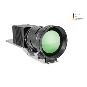
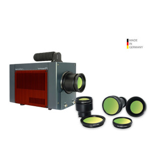
VarioCAM® HD head 800 as a Unique Airborne Multi-Purpose Sensor
Designed as a robust thermography tool, a VarioCAM® HD head 800 has more to offer than sheer measuring accuracy and HD thermal images. Its ruggedised aluminium housing can be provided with IP67 rating (lens included) right off the shelf. The camera´s (1,024 x 768) IR pixels microbolometer achieves NETD values of down to 20 mK, which is a big benefit to support accurate airborne temperature measurements. With 2.5x the pixel count of common VGA resolution cameras, a VarioCAM® offers much more data points for subsequent image analysis. Aerial sensor platforms are typically stabilised, nevertheless the resistant VarioCAM® design and its rugged LEMO connectors support an outstanding system availability and uninterrupted functionality.
The 60 mm f/1.0 infrared lens does not only come with antireflection coatings for improved signal throughput but also with a DLC coating making the lens surface especially hard-wearing. The camera system is fully athermalised also ensuring a best possible measuring accuracy of down to +/-1 K.
As a part of the total aerial thermography solution provided by Trakka there´s more to come for the VarioCAM® HD head 800 at Highland Helicopters: Soon they will be authorised to perform night-time flights supported by their infrared camera and civil defence support for human search activities can be conducted as well. Once tourists will be hiking to the remote places and the Southern Alps – those who might lose their way on the ground can be spotted from a multisensor helicopter with its powerful infrared eye!
Additional activities will be related to predictive maintenance of airborne powerline inspection – another good application of aerial thermography. New Zealand´s power lines are fed by remote hydro power stations, whose inspection is a vital support for the country´s infrastructure.
Do you have questions about this case study?
Get in touch with InfraTec GmbH Infrarotsensork und Messtechnik, and they would be happy to answer any questions you have about pricing, suitability, availability, specs, etc.


![Do-Giant-Tortoises-Make-Good-Neighbors-1[1].jpg](https://cdn.geo-matching.com/vRMO2Edp.jpg?w=320&s=a6108b2726133ff723670b57bc54c812)


