
Breaking New Ground in Waterway Digitization: A Case Study with the AlphaAir 10 LiDAR+RGB System on a DJI Drone
UNLOCKING WATERWAY POTENTIAL: LEVERAGING TECHNOLOGY FOR ENHANCED MANAGEMENT
The digitization of inland waterways brings forth a host of benefits by leveraging technology and data to optimize the management, safety, and sustainability of crucial navigation infrastructure. Precise data on waterway conditions enhances the monitoring of infrastructure structures, such as locks, dams, and bridges. By identifying potential issues early, digitization enables timely maintenance, ensuring the reliability and safety of waterways for transporting goods, passengers, and essential resources.
This article describes the real-world application of the AlphaAir 10 LiDAR+RGB system mounted on a DJI drone for a 3D digitization project focusing on the Yangtze River waterways.
DIGITALIZATION OF THE YANGTZE RIVER'S WATERWAYS: A NEW FRONTIER IN SURVEYING
This project takes on the daunting task of digitally mapping the intricate waterways of the Yangtze River. As the longest river in Eurasia and the third longest in the world, the Yangtze flows through major Chinese provinces, including Sichuan, Yunnan, Hubei, and Shanghai. The river's importance is immeasurable as it's a vital source of millions of people's water, irrigation, and transportation. Recent years have seen a surge in demand for waterway surveying due to ambitious development projects along the Yangtze and its tributaries.

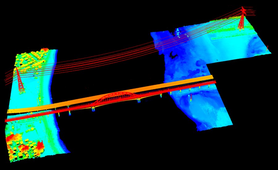
Traditional land-based surveying techniques are struggling to meet the increasing demands for timely and accurate data. The success of digitization initiatives depends on properly allocating resources for data collection and processing. To address this challenge, the local Hydrographic Survey Bureau, in collaboration with CHCNAV's technical experts, deployed the innovative AlphaAir 10 (AA10) LiDAR system for aerial survey operations around the Hanjiang Bridge section. This avant-garde methodology involved meticulous data collection and processing of terrain, buildings, bridges, and cross-river cables – an effort that is driving the digital transformation of the Yangtze River.
PRECISION MADE SIMPLE: 3D MAPPING WITH UAV + LIDAR TECHNOLOGY
Embarking on a journey of high-precision 3D mapping, our project utilized cutting-edge technology - the DJI M300 UAV paired with the AlphaAir 10 (AA10) LiDAR system. The AA10 flawlessly integrates the high-precision LiDAR, accurate GNSS positioning, IMU orientation, and an industrial-grade full-frame orthophoto camera; this dynamic combination delivers not only highly precise laser point clouds but also high-resolution digital imagery, laying the foundation for unparalleled data accuracy.

The data processing revolves around the CoPre and CoProcess software tools from CHCNAV. The CoPre, an advanced and easy-to-use 3D laser scanning pre-processing software, handles raw data, including POS trajectories, LiDAR data, and RGB images. The CoProcess, on the other hand, offers a wide range of post-processing capabilities. This software is a comprehensive solution, from DEM/DTM generation to semi-automatic feature extraction, automatic data classification, and dedicated power line and road inspection modules. Its intuitive interface and streamlined workflow not only increase the precision of 3D mapping projects but also significantly improve productivity, marking a transformative step in the field of aerial mapping.
STREAMLINED EXCELLENCE: EFFORTLESS OPERATION AND RAPID DATA PROCESSING
Efficiency takes center stage in the aerial survey operation, where the installation, collection, and processing of a 2 km² data area were seamlessly accomplished in less than a day. The chronology is as follows:
I. PREPARATION.
The AlphaAir 10 was installed on the DJI M300 UAV in just a few minutes, setting the stage for a quick and efficient operation.
II. FIELD DATA COLLECTION.
The airborne missions were conducted remarkably quickly, taking less than 1 hour for two flights. Information was collected from land areas along the Yangtze River, the Hanjiang Bridge, and cross-river cables.

The entire data collection process was completed in about 50 minutes.
III. DATA PROCESSING AND ANALYSIS.
The next stage involved detailed data processing and analysis. This phase is broken down as follows:
1) COLORED POINT CLOUD PROCESSING.
It took just 19 minutes to process the color point cloud data for two survey areas totaling 1.8 km² using the CoPre software.


This step included a comprehensive scan of steel frames, piers, electrical towers, and cross-river cables, generating point cloud results and facilitating the creation of profiles with direct height measurements for the bridge.


2) AERIAL TRIANGULATION AND 3D MODEL GENERATION.
It then took 12 minutes to complete the aerial triangulation and another 240 minutes to generate the digital orthophoto model (DOM) and real-world 3D model using CoProcess software.


3) DATA REFINEMENT AND DEM GENERATION.
The CoProcess software used to denoise and filter the point clouds demonstrated its efficiency. It took only 30 minutes to generate a highly accurate Digital Elevation Model (DEM) and contours for each 1 km² area with a resolution finer than 1 meter. This accurate DEM is critical for bridge maintenance, environmental impact assessment, flood risk assessment, and infrastructure design.


Leveraging advanced multi-target capabilities, the AlphaAir 10 excelled in penetrating dense vegetation with up to 8 target echoes. This capability enabled effective ground surface acquisition, resulting in accurate Digital Elevation Models (DEMs) and Digital Surface Models (DSMs), even in challenging environments.

The average thickness of the AA10's point cloud, measured at 5 cm, coupled with an elevation error of 3.5 cm, highlights the system's exceptional precision and confirms its position as a technological enabler in aerial surveying applications.

TRANSFORMING WATERWAY SURVEYING: THE POWER OF LIDAR UAV TECHNOLOGY
The impact of the AlphaAir 10 on waterway surveying along the Yangtze River has simply been transformative. This advanced airborne LiDAR system has not only provided highly precise data but has also captured intricate 3D data points that challenge traditional methods. This technological leap has provided surveying professionals with a level of precision that significantly improves decision-making and project planning.
ELEVATING SURVEYING: LIDAR INNOVATION SOARS ALONG THE YANGTZE RIVER
The introduction of LiDAR UAV surveying technology has fundamentally changed the landscape of waterway surveying along the Yangtze River. The efficiency gained over traditional total station surveying methods is significant. Equipped with the AA10 LiDAR + RGB system, the UAVs collected data quickly, reducing the need for extended site access. This minimizes disruption to traffic and surrounding areas and eliminates the risk of human error in data collection, fostering an environment of increased safety for survey professionals.
In essence, the combination of AlphaAir 10's LiDAR and UAV technology has enabled a new era of precision and efficiency in waterway surveying. Its ability to collect data quickly, coupled with unparalleled accuracy, makes it an indispensable tool for surveying professionals along the Yangtze River, setting a new standard for safety and efficiency in the field.
About CHC Navigation
CHC Navigation (CHCNAV) creates innovative mapping, navigation, and positioning solutions to make customers' work more efficient. CHCNAV products and solutions cover multiple industries such as geospatial, construction, agriculture, and marine. With a presence across the globe, distributors in more than 120 countries, and more than 1,700 employees, today, CHC Navigation is recognized as one of the fastest-growing companies in geomatics technologies.
For more information about CHC Navigation [Huace:300627.SZ], please visit: https://www.chcnav.com/about-us/overview
Do you have questions about this case study?
Get in touch with CHC Navigation | CHCNAV, and they would be happy to answer any questions you have about pricing, suitability, availability, specs, etc.

Related products


![Do-Giant-Tortoises-Make-Good-Neighbors-1[1].jpg](https://cdn.geo-matching.com/vRMO2Edp.jpg?w=320&s=a6108b2726133ff723670b57bc54c812)


