
Apglos Survey Wizard
The easiest land survey software in the field
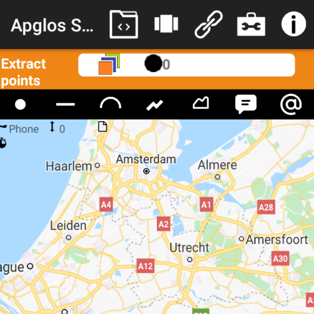
Apglos Survey Wizard is an easy to use land survey app for Android. With this GPS app anyone can start GPS land surveying. It is that simple.
Apglos
Netherlands
Description
Apglos Survey Wizard is a full functional survey app. There are lots of functions within this Android app. But still it is kept very simple. You can try it for free for 30 days. Check it out.
Land surveying
With Apglos Survey Wizard you can survey:
- points
- lines
- arcs
- polylines
- polygons
Besides that you can add comments, symbols and photos. Apglos Survey Wizard works with AutoCAD layers. So it is easy and fast to use.
Staking out
Staking out is another functionality in Apglos Survey Wizard. Just select an item on the integrated Google Maps and this GPS app will tell you the distance and direction to the selected item. There is no need to move and no need to know where North is, just follow the arrow and you will find your item.
Drafting
When you are in the field sometimes you want to add some lines and elements. With Apglos Survey Wizard this is possible. You can with a simple selection form and 1 button draw lines, points, arcs, polylines and polygons. Also you can extend and shorten elements. Besides that there is the possibility to offset elements.
Calculation on-the-go
You can do calculation on-the-go with Apglos Survey Wizard. This is very usefull when you want to know the exact information at the moment. There is no need for an office. In Apglos Survey Wizard you can calculate:
- height differences
- distances
- lengths
- areas
- volumes
GIS functionality
Besides all this Apglos Survey Wizard has GIS functionality. It reads and saves SHP-files. It also can read, change and create attributes to elements like points, lines and areas.
Try it
The best thing of Apglos Survey Wizard is that you don't have to buy it, but that you can try it. Everyone can try this amazing land surveying app for Android for 30 days. Check it out.
Specifications
-
Laser scanning
-
Laser scan data collection
N
Compute unregistered point cloud
N
Point cloud registration to targets in cloud
N
Cloud to cloud registration
N
Scan data output formats supported
-
-
Photogrammetric data processing
-
Photo planning
N
Processing in cloud / on-premise
N
Airborne photography
N
Handheld terrestrial photography
Y
Can more than one camera be used?
Y
Camera calibration computed for all cameras used
N
Accepts input camera calibration data
N
Data from more than one camera supported
N
Accepts GNSS RTK photo exposure positions
N
Supports registration to ground control
N
Output data formats supported
-
-
GNSS data and processing
-
GNSS static / RTK data collection
Y
GNSS setting out
Y
Input data formats supported
NMEA-0183
Static baseline post-processing
N
Output data for least squares adjustment with data from other sources
N
Base and rover RTK
Y
Network RTK
Any
Post processed kinematic
N
-
GNSS + dead reckoning data (mobile mapping)
-
IMU data used trajectory computation
N
SLAM data used in trajectory computation
N
Wheel odometer data used in trajectory computation
N
SfM (photogrammetry) used in trajectory computation
N
Adjust trajectory to fit overlapping point cloud data
N
Adjust trajectory to fit ground control points
N
Adjust point clouds (not trajectory) to fit ground control points
N
Trajectory provided with precision data
N
-
Levelling and Orientation
-
Import of instrument data
-
Rise and fall level book format output
Y
Height of collimation level book format output
Y
Unadjusted levels, adjustment and adjusted level shown
Y
Output data for least squares adjustment with data from other sources
N
-
Total Station (TS) data processing
-
Traverse computation
N
Output data for least squares adjustment with data from other sources
N
Compute 3D radial observations
N
TS setting out
N
Feature attribute coding
N
Feature geometry coding
N
Data input formats supported
-
Data output formats supported
-
-
CAD functions
-
CAD functions for Internal measured building surveys
Y
CAD functions for open drainage modelling
N
CAD functions for Rail applications
Y
CAD functions for Road applications
Y
CAD functions for Pipeline applications
Y
CAD functions for Overhead Power Line applications
Y
CAD functions for Site development applications
Y
CAD functions for Industrial plant applications
Y
Output formats supported
DXF, AGL, TXT, CSV, AGP, SHP, KML, XML
-
General
-
Software version
1.12
Mobile (real time connected to instrument)
Y
Laptop / Office computer (post processing)
N
-
Integrated environment for
-
GNSS data
Y
GNSS + dead reckoning data (Mobile Mapping)
Y
TPS data
Y
Point cloud data
N
Level data
Y
Integrated least squares computation of control
Y
Transformation between map projections
Y
Compute grid DTM
Y
Compute TIN
Y
Computation of sections through surfaces
N
Volume computation from sections
Y
Volume computation by substracting surfaces
Y

