


i83 IMU-RTK GNSS
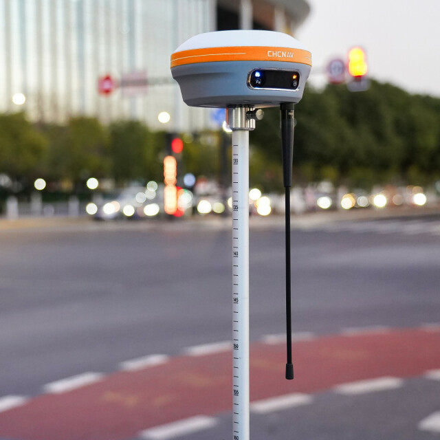
Smart and Versatile IMU-RTK GNSS Receiver
The i83 GNSS receiver is more than a universal 1408-channel multi-band IMU-RTK GNSS receiver, it is the perfect GNSS RTK survey tool that any surveying, construction, or mapping professional has come to expect. Built-in connectivity modules such as Wi-Fi, Bluetooth, NFC, UHF, and 4G modem can be used reliably, efficiently, and conveniently in a variety of application scenarios to meet any job site configuration.

CHC Navigation | CHCNAV
Shanghai, CN
Description
-
BEYOND GNSS RTK SURVEY
Powered by 1408-channel GNSS and iStar technology
The i83 GNSS smart antenna delivers centimetre precision in seconds and maintains reliable fixed RTK accuracy even in typically challenging environments. Its quick-start feature gets you up and running within 30 seconds of powering up the receiver, making point collection faster than ever as you move from place to place. The third-generation high-gain antenna increases GNSS satellite signals tracking efficiency by up to 30% and provides accurate, survey-grade positioning using GPS, Glonass, BeiDou, Galileo, and QZSS constellations. The integrated iStar technology ensures optimal GNSS RTK surveying in all GNSS survey applications.
-
ENGINEERED FOR FIELD USE
18 hours on a single charge to ensure operation when you need it
The i83 GNSS ultra-low-power SoC (System-on-Chip) electronic design and smart power management dramatically improve GNSS survey time span and eliminate the need for spare or external batteries. Up to 18 hours of autonomous work are achieved when operated as a GNSS RTK network rover and up to 9 hours as an RTK base station. i83 GNSS charges from a power bank or a standard USB-C charger. No matter where or when the GNSS surveys are carried out, the i83 GNSS' magnesium alloy body is shock-, dust- and waterproof to ensure uninterrupted performance, even in the most demanding job site conditions.
-
SMARTER CONNECTIVITY THAN EVER
Unrivalled universal GNSS receiver
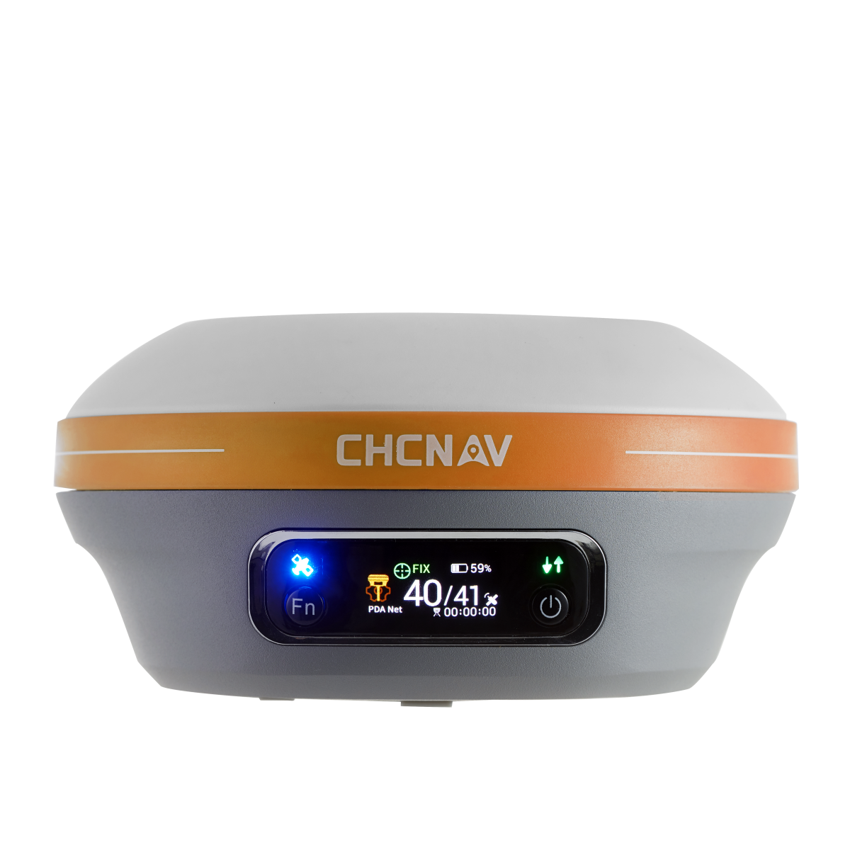
i83 GNSS has all the connectivity features a surveyor needs to complete any GNSS surveying project scenario. Built-in Wi-Fi, Bluetooth, and NFC technologies provide a seamless connection to field data controllers and tablets. Integrated 4G and UHF modems enable any GNSS surveying mode, from RTK Networks NTRIP connections to UHF base-rover configuration. GNSS RTK corrections are accessed or broadcasted continuously for accurate positioning in all circumstances. The high-resolution colour display provides a clear view of the i83 GNSS status. Whether it is set up as a UHF RTK base station, recording raw data for further GNSS post-processing, or simply being used as a UHF or 4G network rover, it provides full control of survey operations.
-
GNSS SURVEY TOOL FOR EVERYONE
An efficient IMU-RTK survey made it easy.
The i83 GNSS built-in IMU for automatic pole tilt compensation boosts surveying, engineering, and mapping speed and efficiency by up to 30%. Real-time, interference-free initialization of the 200 Hz inertial module is achieved in just 5 seconds and ensures 3-centimetre accuracy over a pole tilt range of up to 30 degrees. Measuring and staking out with the i83 GNSS is fast, easy, and highly productive, whether you are an engineer, site foreman, or surveyor.
The i83 GNSS receiver is more than a universal 1408-channel multi-band IMU-RTK GNSS receiver. It is the perfect GNSS RTK survey tool that any surveying, construction, or mapping professional has come to expect. Built-in connectivity modules such as Wi-Fi, Bluetooth, NFC, UHF, and 4G modem can be used reliably, efficiently, and conveniently in various application scenarios to meet any job site configuration.
The i83 GNSS features CHCNAV's third-generation GNSS antenna and the latest iStar algorithm to increase all GNSS signal tracking efficiency by 30%. It also integrates a premium calibration-free IMU sensor, which greatly improves the usability and reliability of RTK GNSS surveys. Designed for extended field use and robust performance, the i83 GNSS smart power management technology allows for up to 18 hours of continuous RTKrover operation. The i83 GNSS provides unparalleled productivity for GNSS measurements, stakeout surveys, and other typical construction tasks.
Do you have questions about this product?
- Questions about price, availability, and/or retailers
- Questions about technical specifications and usage
- Questions about suitability for your project or application
Specifications
-
General
-
Type
Land
Year of initial introduction
2022
Height [m]
0.078
Depth [m]
0.152
Width [m]
0.152
Total Weight [kg]
1.15
-
Performance
-
No. channels
1408
Tracked satellite signals
GPS: L1 C/A, L2C, L2P, L5. GLONASS: L1, L2. Galileo: E1, E5a, E5b, E6*. BeiDou: B1I, B2I, B3I, B1C, B2a, B2b*. SBAS: L1. QZSS: L1, L2, L5, L6*.
SBAS differential signals
L1
-
Environment
-
Operating temperature: min. [°C]
-40
Operating temperature: max. [°C]
65
Humidity resistance
100% condensation
Water sand and dust proof
IP67 waterproof and dustproof. Prevent water vapor from entering the device under harsh environments such as sun exposure and sudden heavy rain
Shock and vibration proof
Protected from temporary immersion to depth of 1 m. Survive a 2-meter pole drop
-
Power
-
Typical consumption [W]
4.5
Internal power supply
Built-in non-removable battery 9,600 mAh, 7.4 V
Operating time with internal power supply [hr]
18
Certifications
CE/FCC
-
Recording
-
Type of data (on board recording)
RTCM 2.x, RTCM 3.x, CMR input / output HCN, HRC, RINEX 2.11, 3.02 NMEA 0183 output NTRIP Client, NTRIP Caster
Documents
Brochure
i83_DS_EN (2).pdf
752.77 KB


