
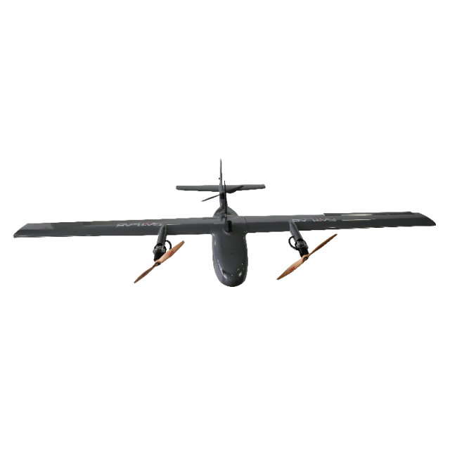
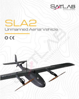
SLA-2 VTOL Drone Mapping
A photogrammetry UAS delivering high accuracy point cloud and orthophoto
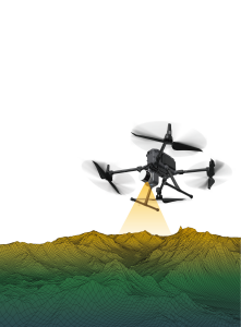
The Satlab SLA-2 drone mapping is a photogrammetry UAS delivering high accuracy point cloud and orthophoto. With a highly optimized airframe, it features detachable pieces for easy transportation and operation. This model also has an advanced autopilot system that ensures safe operation at ease.

SatLab
Vastra Frolunda, SE
Description
SLA-2 VTOL Drone Mapping
 |
|
Vertical Take-off and Landing (VTOL)
Drone Mapping is Designed and developed for vertical take-off and landing, the drone mapping SLA-2 is a fully autonomous UAV capable of up to 75 minutes of flight time. This industrial quality UAV allows a maximum payload of 1kg with a cruise speed of 80km/h.
Easy and Safe System
The Satlab SLA-2 drone mapping is a photogrammetry UAS delivering high accuracy point cloud and orthophoto. With a highly optimized airframe, it features detachable pieces for easy transportation and operation. This model also has an advanced autopilot system that ensures safe operation at ease.
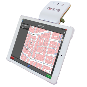
Mission Planning Software
Plan and upload your mission route to the drone mapping SLA-2 autopilot using the Mission Planning Software.
Integrated Dual Frequency
The SLA-2 has an integrated dual frequency RTK (GPS/GLONASS/BEIDOU) receiver which reduces the number of Ground Control Points (GCPs) required. There is a safety feature with a motor placed in the pusher configuration AFT of airframe, that significantly reduces the risk of an accident.
Do you have questions about this product?
- Questions about price, availability, and/or retailers
- Questions about technical specifications and usage
- Questions about suitability for your project or application
Specifications
-
Environment
-
Min. operation temperature [°C]
-10
Max. operation temperature [°C]
45
-
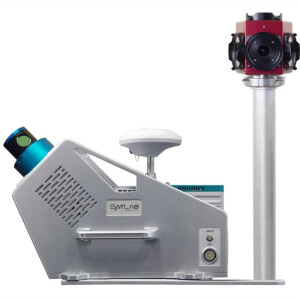
Imaging/scanning devices
-
Type of Camera
Sony RX1RM2 42.4M Pixel 35mm F2.0 Carl Zeiss Lens
Build-in Stablilsation
Y
Sensor tilting to allow oblique views
N
Onboard imaging/scanning devices
-
Platform
-
Brand
SatLab
Max. stay in the air [min]
75
Max. speed [km/h]
80
Propulsion
elecric
Platform
Aircraft
Max. payload [kg]
1
-
Operation Characteristics and Safety
-
Launching method
Hand
Automatic launch and landing
Y
Collision avoidance systems (CAS)
N
-
Dimensions
-
ø / wingspan [cm]
240
Weight [kg]
6.8
Transport on human back
Y
Length [cm]
150
-
Base Station
-
Ground computer included
Y
Type of Ground computer
Controls + Tranceiver for RTK Corrections
Sensor control
Y
Real time image and video download link
Y
-
Navigation Sensors
-
Type of GNSS receiver and captured signals
SatLab ”Sponge” Dual frequency RTK GPS/GLONASS/BD
Type of IMU
Industry standard Microprocessor AP with IMU
Other sensors and additional information
900Mhz Operating Frequency
-
General
-
Typical applications
Mapping, 3D modelling, Surveying
-
Included software and automatically generated
-
Type of software included
Flight planning
Flight planning software
Yes, included
Automatically Generated Products
3D Landscape Models, DEMs, Orthomosaics
Documents
Brochure
sla-2-drone-mapping
