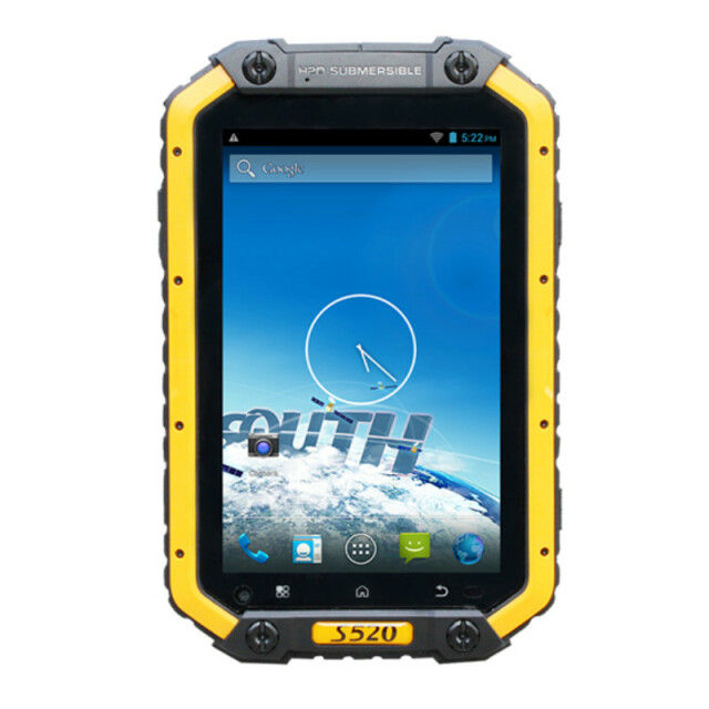
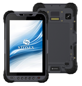
S520
Ultra-rugged Tablet Computer
With industrial standard and high performance, SOUTH S520 is designed for ease of use GNSS receiving terminal, integrated with professional 1.2GHz quad-core processor, 1GB RAM and 16GB ROM, ensure that the software runs unobstructed and your demand of data storage.
SOUTH Surveying & Mapping
Guangzhou, CN
Description
With industrial standard and high performance, SOUTH S520 is
designed for ease of use GNSS receiving terminal, integrated
with professional 1.2GHz quad-core processor, 1GB RAM and
16GB ROM, ensure that the software runs unobstructed and
your demand of data storage.
For data collection, inspection and maintenance, based on the
most advanced and compatible Android 4.2.2 operating system,
equipped with electric compass, Barometer and G-sensor, yet
fully integrated with all the features you need in the field. South
S520 tablet meets the challenge in GIS applications, provides a
good platform of hardware and software, allows you to run the
third-party software and customize GIS data collecting software.
What's more, with featuring the professional OS, you can bring
your office to the field, collecting information, capturing photos
and communicating with your team wherever you are, the office
can get up to date from the field operations in real time.
With the rapid development of GIS industry, tablet has become
a trend, it is widely used in utility companies, environmental
management agencies, municipal administration, agriculture
and forestry, Public Safety, transportations, Telecommunications,
Natural Resources and other industries.
Meanwhile, the ultra-rugged frame with IP68 industrial level
protection, the tablet offers everything you expect, it works well
in extremely tough conditions like humidity extremes, vibration
and shock. The more computing power and large size screen
device, makes it easier to view and use detailed maps, which is a
solution of GIS users have been looking for.
Specifications
-
General
-
Main design elements
hardware
Total Weight [kg]
0.61
Width [m]
0.2125
Height [m]
0.0191
Depth [m]
0.135
Resolution: horizontal pixels
1280
Resolution: vertical pixels
800
Touchscreen
Y
-
More information
-
Distinguishable features
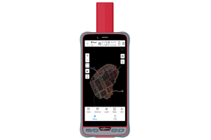
IP68 Rated, designed to survive 1.5 meter drop on concrete, 10 hours or more battery life, G-Sensor, Digital Compass, Barometer, Ambient light sensor, 8MP rear and 2MP front facing camera, Voice call, MMS, SMS
Main applications
Utility companies, environmental management agencies, municipal administration, agriculture and forestry, Public Safety, transportations, Telecommunications, Natural Resources and other industries.
-
Software
-
Name of GIS package
Giscuit
Zooming
Y
Panning
Y
Editing of points
Y
Editing of lines
Y
Editing of polygons
Y
Editing of attributes
Y
Query
Y
Sketching of notes on map
Y
Display of external data and photos
Y
Measurements: length
Y
Measurements: area
Y
-
Connectivity
-
User Interfaces
Android
Wireless Data Transfer
WCDMA 2100/1900/850; GSM 1900/1800/900/850 MHz
Bluetooth
Y
Ports
Micro USB 2.0 high speed
WiFi
Y
-
GNSS Receiver
-
GNSS Systems Supported
GPS
Compatible GNSS correction signals
DGPS
-
Computer
-
Processor
1.2 GHz quad-core
RAM [MB]
1024
Hard Disk [MB]
16384
Types of Replaceable Memory
T-Flash storage, extendable 32GB
Audio: speaker
Y
Range measurement
N
Operating System
Android
Built-in Camera: megapixels
8
Hard Disk
Flash
Audio: microphone
Y
-
Operation Characteristics
-
Integrated sensors


