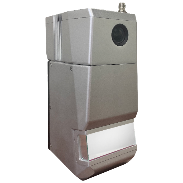
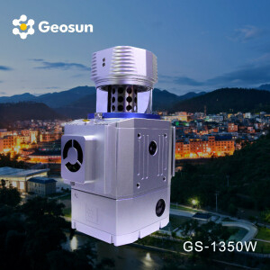
Geosun LiDAR GS-1500N
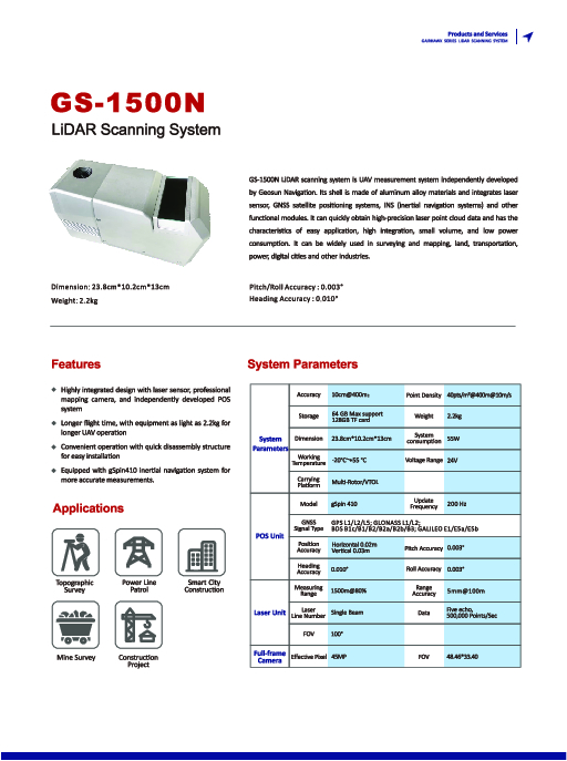
The Professional LiDAR system stands out for its distinctive benefits, including cost-effectiveness, long-range detection capability of up to 1500 meters, a high-end POS (Position and Orientation System), and an integrated 45MP full-frame camera.
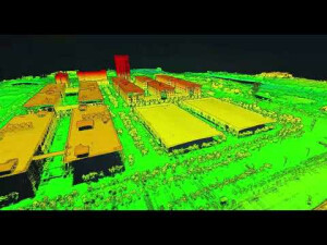
The GS-1500N Lidar scanning system is designed for UAVs. This system is comprised of an aluminium alloy shell and incorporates various functional modules such as a laser scanner, GNSS satellite positioning systems, and INS inertial navigation system. It enables the fast acquisition of precise laser point cloud data and possesses features like user-friendly application, high integration, compact size, and low power consumption.

Geosun Navigation
Wuhan, CN
Description
The GS-1500N Lidar scanning system is a UAV measurement system. This system is comprised of an aluminium alloy shell and incorporates various functional modules such as laser scanners, GNSS satellite positioning systems, and INS inertial navigation systems. It enables the fast acquisition of precise laser point cloud data and possesses features like user-friendly application, high integration, compact size, and low power consumption. It finds extensive applications in industries such as surveying and mapping, land management, transportation, power, and digital cities.
|
LiDAR scanning system gAirHawk GS-1500N |
||
|
Item Name |
System Parameters |
|
|
GS-1350N Parameters |
Weight |
2.5kg |
|
Working temperature |
-20℃~+60℃ |
|
|
Power range |
12 V- 24 V |
|
|
Consumption |
65 W |
|
|
Carrying Platform |
6 Aixs Multi Rotor Drone,VTOL |
|
|
Storage |
64 GB storage, maximum support 128GB TF card |
|
|
Laser Unit |
Measuring Range |
1500m@80% |
|
Laser class |
1535 nm Class1 (IEC 60825-1:2014) |
|
|
Laser line number |
FT-800 Single-Beam |
|
|
Measuring accuracy |
5mm@100m |
|
|
Max. range |
1500m |
|
|
Return |
5 echos |
|
|
Scanning frequency |
50HZ-2000HZ |
|
|
Beam Divergence |
0.3mrad |
|
|
FOV |
100°, adjustable |
|
|
POS Unit |
Update frequency |
200HZ |
|
Heading accuracy |
0.010° |
|
|
Pitch accuracy |
0.003° |
|
|
Rolling accuracy |
0.003° |
|
|
Position accuracy |
Horizontal: 0.01m, Vertical: 0.02m |
|
|
GNSS signal type |
GPSL1/L2/L5 GLONASSL1/L2 BDS B1/B2/B3 GAL E1/E5a/5b |
|
|
IMU |
gSpin 410 |
|
|
Pre-processing software |
POS software |
Output information: position, speed, attitude |
|
Point cloud software |
Output point cloud data format: LAS format, custom TXT format |
|
|
Camera (built-in) |
FOV |
48*33 Degree |
|
Effective Pixel |
45 MP (Full Frame Camera) |
|
|
focal Length(mm) |
16 |
|
Do you have questions about this product?
- Questions about price, availability, and/or retailers
- Questions about technical specifications and usage
- Questions about suitability for your project or application
Specifications
-
General
-
Year of introduction
2022
Year of last update
2022
Total Weight [kg]
2.5kg
Power requirements
24V
Type of GNSS/INS positioning system
GPSL1/L2/L5 GLONASSL1/L2 BDS B1/B2/B3 GAL E1/E5a/5b
Camera
Full frame
Data storage facilities
64 GB storage, maximum support 128GB TF card
Mission planning software
WPS
-
Operation Characteristics
-
Platform
-
Laser Pulse Characteristics
-
Wavelength [nm]
1535
Beam divergence [mrad]
0.5
Type/class laser
Class 1
-
Uncertainty and resolution
-
Pitch and roll pointing precision [deg]
0.003
Heading pointing precision [deg]
0.01
-
Application areas
-
Select an application area:
Documents
Brochure
1500n.pdf
1.63 MB
Videos

